You are here: Home > Network List > TA - USArray Transportable Network (new EarthScope stations) Stations List
> Station H09A Durkee, OR, USA > Earthquake Result Viewer
H09A Durkee, OR, USA - Earthquake Result Viewer
| Earthquake location: |
San Juan Province, Argentina |
| Earthquake latitude/longitude: |
-31.7/-67.2 |
| Earthquake time(UTC): |
2006/09/17 (260) 09:34:14 GMT |
| Earthquake Depth: |
142 km |
| Earthquake Magnitude: |
5.7 MB, 6.2 MW, 6.2 MW |
| Earthquake Catalog/Contributor: |
WHDF/NEIC |
|
| Network: |
TA USArray Transportable Network (new EarthScope stations) |
| Station: |
H09A Durkee, OR, USA |
| Lat/Lon: |
44.67 N/117.66 W |
| Elevation: |
1263 m |
|
| Distance: |
88.9 deg |
| Az: |
326.589 deg |
| Baz: |
138.896 deg |
| Ray Param: |
0.04197175 |
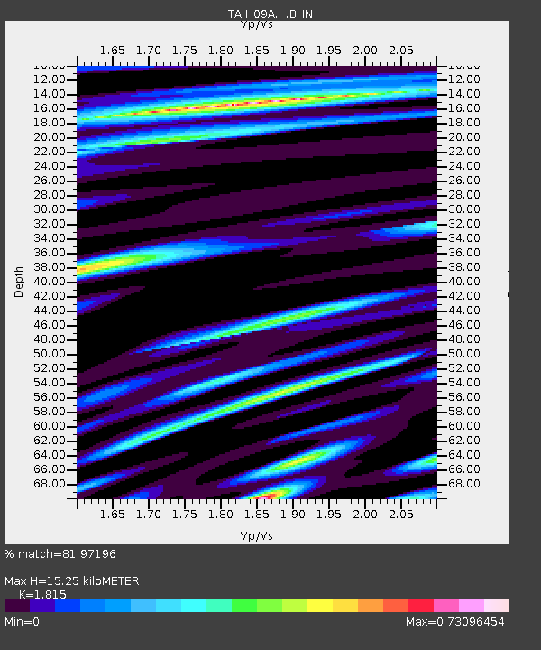
| Estimated Moho Depth: |
15.25 km |
| Estimated Crust Vp/Vs: |
1.82 |
| Assumed Crust Vp: |
6.571 km/s |
| Estimated Crust Vs: |
3.62 km/s |
| Estimated Crust Poisson's Ratio: |
0.28 |
|
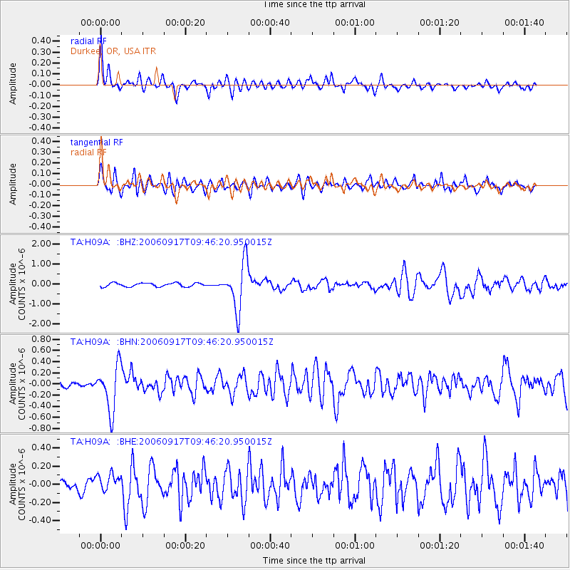
| Radial Match: |
81.97196 % |
| Radial Bump: |
400 |
| Transverse Match: |
79.112114 % |
| Transverse Bump: |
400 |
| SOD ConfigId: |
2665 |
| Insert Time: |
2010-03-07 01:35:56.647 +0000 |
| GWidth: |
2.5 |
| Max Bumps: |
400 |
| Tol: |
0.001 |
|
Signal To Noise
| Channel | StoN | STA | LTA |
| TA:H09A: :BHN:20060917T09:46:20.950015Z | 5.5669537 | 4.192424E-7 | 7.5309124E-8 |
| TA:H09A: :BHE:20060917T09:46:20.950015Z | 1.0452635 | 9.3378254E-8 | 8.933466E-8 |
| TA:H09A: :BHZ:20060917T09:46:20.950015Z | 13.635384 | 1.2281453E-6 | 9.0070465E-8 |
| Arrivals |
| Ps | 1.9 SECOND |
| PpPs | 6.4 SECOND |
| PsPs/PpSs | 8.3 SECOND |


