You are here: Home > Network List > TA - USArray Transportable Network (new EarthScope stations) Stations List
> Station H09A Durkee, OR, USA > Earthquake Result Viewer
H09A Durkee, OR, USA - Earthquake Result Viewer
| Earthquake location: |
Solomon Islands |
| Earthquake latitude/longitude: |
-6.8/155.5 |
| Earthquake time(UTC): |
2006/09/01 (244) 10:18:51 GMT |
| Earthquake Depth: |
38 km |
| Earthquake Magnitude: |
6.3 MB, 6.7 MS, 6.8 MW, 6.7 MW |
| Earthquake Catalog/Contributor: |
WHDF/NEIC |
|
| Network: |
TA USArray Transportable Network (new EarthScope stations) |
| Station: |
H09A Durkee, OR, USA |
| Lat/Lon: |
44.67 N/117.66 W |
| Elevation: |
1263 m |
|
| Distance: |
92.4 deg |
| Az: |
45.491 deg |
| Baz: |
262.987 deg |
| Ray Param: |
0.04144345 |
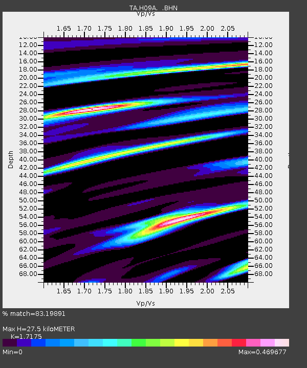
| Estimated Moho Depth: |
27.5 km |
| Estimated Crust Vp/Vs: |
1.72 |
| Assumed Crust Vp: |
6.571 km/s |
| Estimated Crust Vs: |
3.826 km/s |
| Estimated Crust Poisson's Ratio: |
0.24 |
|
| Radial Match: |
83.19891 % |
| Radial Bump: |
400 |
| Transverse Match: |
77.809074 % |
| Transverse Bump: |
400 |
| SOD ConfigId: |
2665 |
| Insert Time: |
2010-03-07 01:35:58.317 +0000 |
| GWidth: |
2.5 |
| Max Bumps: |
400 |
| Tol: |
0.001 |
|

Signal To Noise
| Channel | StoN | STA | LTA |
| TA:H09A: :BHN:20060901T10:31:27.175012Z | 1.3749058 | 1.2961607E-7 | 9.4272686E-8 |
| TA:H09A: :BHE:20060901T10:31:27.175012Z | 2.8878956 | 2.781313E-7 | 9.6309336E-8 |
| TA:H09A: :BHZ:20060901T10:31:27.175012Z | 7.818644 | 9.930793E-7 | 1.2701426E-7 |
| Arrivals |
| Ps | 3.1 SECOND |
| PpPs | 11 SECOND |
| PsPs/PpSs | 14 SECOND |


