You are here: Home > Network List > TA - USArray Transportable Network (new EarthScope stations) Stations List
> Station H09A Durkee, OR, USA > Earthquake Result Viewer
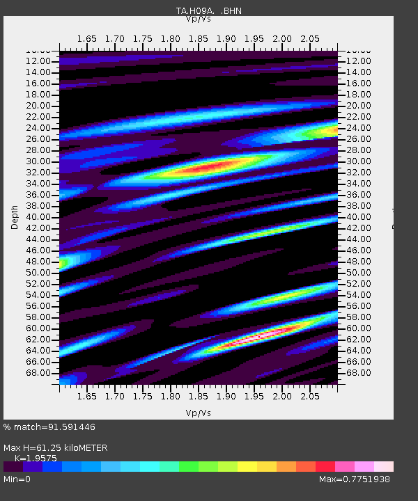
H09A Durkee, OR, USA - Earthquake Result Viewer
| Earthquake location: |
Near East Coast Of Kamchatka |
| Earthquake latitude/longitude: |
51.1/157.5 |
| Earthquake time(UTC): |
2006/08/24 (236) 21:50:36 GMT |
| Earthquake Depth: |
43 km |
| Earthquake Magnitude: |
5.9 MB, 6.2 MS, 6.5 MW, 6.5 MW |
| Earthquake Catalog/Contributor: |
WHDF/NEIC |
|
| Network: |
TA USArray Transportable Network (new EarthScope stations) |
| Station: |
H09A Durkee, OR, USA |
| Lat/Lon: |
44.67 N/117.66 W |
| Elevation: |
1263 m |
|
| Distance: |
54.2 deg |
| Az: |
61.171 deg |
| Baz: |
309.351 deg |
| Ray Param: |
0.065496676 |
| Estimated Moho Depth: |
61.25 km |
| Estimated Crust Vp/Vs: |
1.96 |
| Assumed Crust Vp: |
6.571 km/s |
| Estimated Crust Vs: |
3.357 km/s |
| Estimated Crust Poisson's Ratio: |
0.32 |
|
| Radial Match: |
91.591446 % |
| Radial Bump: |
400 |
| Transverse Match: |
86.89706 % |
| Transverse Bump: |
400 |
| SOD ConfigId: |
2665 |
| Insert Time: |
2010-03-07 01:36:02.192 +0000 |
| GWidth: |
2.5 |
| Max Bumps: |
400 |
| Tol: |
0.001 |
|

Signal To Noise
| Channel | StoN | STA | LTA |
| TA:H09A: :BHN:20060824T21:59:27.350012Z | 22.794048 | 1.3922333E-6 | 6.107881E-8 |
| TA:H09A: :BHE:20060824T21:59:27.350012Z | 17.4923 | 8.012481E-7 | 4.5805763E-8 |
| TA:H09A: :BHZ:20060824T21:59:27.350012Z | 38.29973 | 2.9658281E-6 | 7.7437306E-8 |
| Arrivals |
| Ps | 9.4 SECOND |
| PpPs | 26 SECOND |
| PsPs/PpSs | 36 SECOND |


