You are here: Home > Network List > TA - USArray Transportable Network (new EarthScope stations) Stations List
> Station L04A Klamath Falls, OR, USA > Earthquake Result Viewer
L04A Klamath Falls, OR, USA - Earthquake Result Viewer

| Earthquake location: |
Near Coast Of Peru |
| Earthquake latitude/longitude: |
-13.4/-76.6 |
| Earthquake time(UTC): |
2007/08/15 (227) 23:40:57 GMT |
| Earthquake Depth: |
39 km |
| Earthquake Magnitude: |
6.7 MB, 7.9 MS, 8.0 MW, 7.5 ME |
| Earthquake Catalog/Contributor: |
WHDF/NEIC |
|
| Network: |
TA USArray Transportable Network (new EarthScope stations) |
| Station: |
L04A Klamath Falls, OR, USA |
| Lat/Lon: |
42.17 N/121.89 W |
| Elevation: |
1336 m |
|
| Distance: |
69.2 deg |
| Az: |
325.593 deg |
| Baz: |
132.286 deg |
| Ray Param: |
0.055735894 |
| Estimated Moho Depth: |
38.0 km |
| Estimated Crust Vp/Vs: |
1.75 |
| Assumed Crust Vp: |
6.597 km/s |
| Estimated Crust Vs: |
3.759 km/s |
| Estimated Crust Poisson's Ratio: |
0.26 |
|
| Radial Match: |
95.34359 % |
| Radial Bump: |
394 |
| Transverse Match: |
88.09606 % |
| Transverse Bump: |
400 |
| SOD ConfigId: |
2564 |
| Insert Time: |
2010-03-07 01:44:27.723 +0000 |
| GWidth: |
2.5 |
| Max Bumps: |
400 |
| Tol: |
0.001 |
|
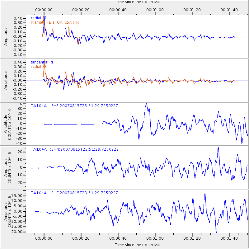
Signal To Noise
| Channel | StoN | STA | LTA |
| TA:L04A: :BHN:20070815T23:51:29.725022Z | 13.4421215 | 9.102261E-7 | 6.771447E-8 |
| TA:L04A: :BHE:20070815T23:51:29.725022Z | 4.8936834 | 8.610599E-7 | 1.7595333E-7 |
| TA:L04A: :BHZ:20070815T23:51:29.725022Z | 27.191303 | 2.7743336E-6 | 1.0203018E-7 |
| Arrivals |
| Ps | 4.5 SECOND |
| PpPs | 15 SECOND |
| PsPs/PpSs | 20 SECOND |


