
Station TA L04A - Klamath Falls, OR, USA
Network: TA - USArray Transportable Network (new EarthScope stations)
Nearby stations (2 deg radius)
| Station | Name | (Lat, Lon) | Start / End | Elevation |
| L04A | Klamath Falls, OR, USA | (42.17, -121.89) | 2006-05-24 / 2499-01-01 | 1.3 km |
| Crust2 Type: | L3,continental arc, Southern Andes, 0.2 km seds. |
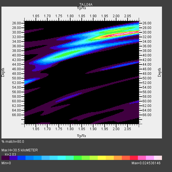
| Thickness Estimate: | 30 km |
| Thickness StdDev: | 1.5 km |
| Vp/Vs Estimate: | 2.03 |
| Vp/Vs StdDev: | 0.04 |
| Vs Estimate: | 3.25 km/s |
| Poisson's Ratio: | 0.34 |
| Peak Value: | 0.02 |
| Assumed Vp: | 6.597 km/s |
| Ps Weight: | 0.33333334 |
| PpPs Weight: | 0.33333334 |
| PsPs Weight: | 0.33333328 |
| Residual Complexity: | 0.489 |
| Nearby stations H: | +- |
| (2.0 deg) Vp/Vs: | +- |
12 with match > 90% ( 33.333332 %) and 36 with match > 80% ( 100.0 %) out of 36.
Download stack as xyz text file.
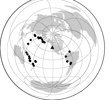
Azimuth Distribution of Events:
Prior Results for this Station
| Study | Thickness | Vp/Vs | Vp | Vs | Poissons Ratio | Extra |
| EARS | 30 km | 2.03 | 6.597 km/s | 3.25 km/s | 0.34 | |
| Crust2.0 | 40 km | 1.77 | 6.597 km/s | 3.723 km/s | 0.27 | L3,continental arc, Southern Andes, 0.2 km seds. |
| Global Maxima | 30 km | 2.03 | 6.597 km/s | 3.25 km/s | 0.34 | amp=0.024536146 |
| Local Maxima 1 | 29 km | 1.97 | 6.597 km/s | 3.345 km/s | 0.33 | amp=0.011269903 |
| Local Maxima 2 | 41 km | 1.74 | 6.597 km/s | 3.803 km/s | 0.25 | amp=0.009371197 |
| Local Maxima 3 | 38 km | 1.80 | 6.597 km/s | 3.67 km/s | 0.28 | amp=0.0059619145 |
| Local Maxima 4 | 44 km | 2.04 | 6.597 km/s | 3.238 km/s | 0.34 | amp=0.0032472499 |
| Predicted Arrivals for vertical incidence (zero ray parameter) | |
| Ps | 4.76 SECOND |
| PpPs | 14.01 SECOND |
| PsPs/PpSs | 18.77 SECOND |
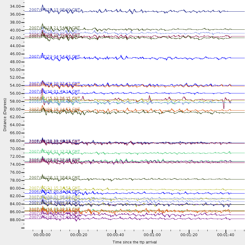
Events Processed for this Station
Download zip of receiver functions as SAC
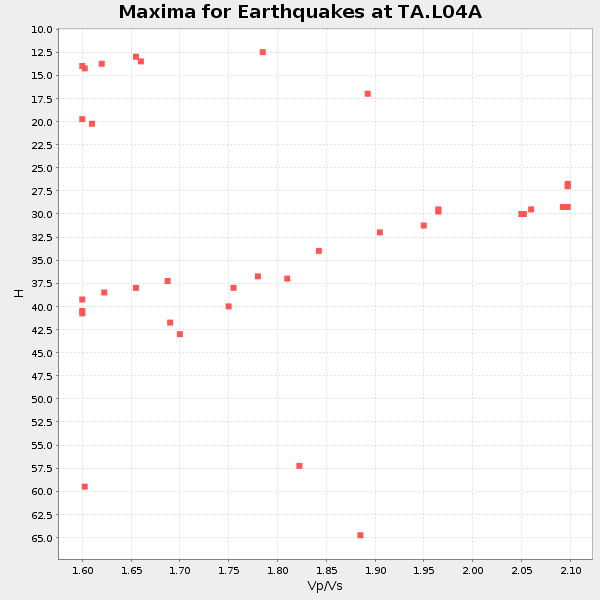
Plot maxima for each earthquake.
Events Used in the Stack
(36 events)| Radial Match | Distance | Baz | FERegion | Time | Lat/Lon | Depth | Magnitude |
| 96.036446 | 86.5 deg | 245.462 deg | Vanuatu Islands | 2007/08/01 17:08:51 GMT | (-15.6, 167.7) | 120 km | 6.2 MB, 7.2 MW, 7.2 MW |
| 96.03377 | 58.0 deg | 305.881 deg | Kuril Islands | 2006/11/15 11:14:13 GMT | (46.6, 153.3) | 10 km | 6.5 MB, 7.8 MS, 8.3 MW, 7.9 MW |
| 95.36726 | 85.0 deg | 249.591 deg | Santa Cruz Islands | 2007/09/02 01:05:18 GMT | (-11.6, 165.8) | 35 km | 5.9 MB, 7.3 MS, 7.2 MW, 6.9 ME |
| 95.34359 | 69.2 deg | 132.286 deg | Near Coast Of Peru | 2007/08/15 23:40:57 GMT | (-13.4, -76.6) | 39 km | 6.7 MB, 7.9 MS, 8.0 MW, 7.5 ME |
| 93.07552 | 57.4 deg | 305.021 deg | East Of Kuril Islands | 2007/01/13 04:23:21 GMT | (46.2, 154.5) | 10 km | 7.3 MB, 8.2 MS, 8.1 MW, 7.9 MW |
| 92.28437 | 74.5 deg | 229.8 deg | Samoa Islands Region | 2006/09/28 06:22:09 GMT | (-16.6, -172.0) | 28 km | 6.5 MB, 6.6 MS, 6.9 MW, 6.7 MW |
| 91.18237 | 79.4 deg | 289.984 deg | Volcano Islands, Japan Region | 2007/09/28 13:38:59 GMT | (22.0, 142.7) | 276 km | 6.7 MB, 7.4 MW, 7.4 MW |
| 91.1491 | 74.4 deg | 231.895 deg | Tonga Islands | 2006/07/07 07:26:12 GMT | (-15.2, -173.6) | 35 km | 5.7 MB, 5.9 MS, 6.0 MW, 6.0 MW |
| 90.99092 | 53.1 deg | 310.494 deg | Kamchatka Peninsula, Russia | 2007/05/30 20:22:12 GMT | (52.1, 157.3) | 116 km | 6.4 MB, 6.4 MW, 6.4 MW |
| 90.4817 | 86.5 deg | 245.253 deg | Vanuatu Islands | 2006/08/07 22:18:54 GMT | (-15.8, 167.8) | 141 km | 6.0 MB, 6.8 MW, 6.8 MW |
| 90.20161 | 72.1 deg | 304.58 deg | Near West Coast Of Honshu, Japan | 2007/07/16 01:13:22 GMT | (37.5, 138.4) | 12 km | 6.5 MB, 6.4 MS, 6.6 MW, 6.5 MW |
| 90.18903 | 85.7 deg | 244.977 deg | Vanuatu Islands | 2007/07/15 09:27:34 GMT | (-15.4, 168.6) | 8.0 km | 6.0 MB, 5.8 MS, 6.1 MW, 6.0 MW |
| 89.89158 | 88.2 deg | 255.165 deg | Solomon Islands | 2007/08/16 08:39:27 GMT | (-9.8, 159.5) | 10 km | 6.1 MB, 6.7 MS, 6.4 MW |
| 89.514915 | 38.5 deg | 301.837 deg | Andreanof Islands, Aleutian Is. | 2007/08/15 20:22:11 GMT | (50.3, -177.5) | 9.0 km | 6.3 MB, 6.2 MS, 6.4 MW, 5.9 ML |
| 88.52884 | 57.2 deg | 306.51 deg | Kuril Islands | 2006/11/15 12:26:15 GMT | (47.4, 153.9) | 10 km | 5.7 MB |
| 88.02752 | 37.5 deg | 304.083 deg | Andreanof Islands, Aleutian Is. | 2007/07/13 21:54:43 GMT | (51.8, -176.3) | 35 km | 5.7 MB, 5.6 MS, 6.0 MW, 5.9 MW |
| 87.505585 | 32.4 deg | 304.633 deg | Fox Islands, Aleutian Islands | 2007/07/15 13:08:00 GMT | (52.5, -168.0) | 10 km | 5.8 MB, 5.9 MS, 6.1 MW, 6.0 MW |
| 87.18937 | 90.5 deg | 259.768 deg | Solomon Islands | 2007/06/28 02:52:09 GMT | (-8.0, 154.6) | 10 km | 6.3 MB, 6.7 MS, 6.7 MW, 6.7 MW |
| 87.09524 | 39.5 deg | 303.541 deg | Andreanof Islands, Aleutian Is. | 2006/07/08 20:40:00 GMT | (51.2, -179.3) | 22 km | 6.2 MB, 6.4 MS, 6.6 MW, 6.6 MW |
| 86.867836 | 39.9 deg | 303.798 deg | Andreanof Islands, Aleutian Is. | 2007/08/02 03:21:42 GMT | (51.3, -180.0) | 21 km | 6.3 MB, 6.6 MS, 6.7 MW, 6.6 MW |
| 86.72479 | 55.3 deg | 122.582 deg | Near West Coast Of Colombia | 2007/09/10 01:49:14 GMT | (3.0, -78.0) | 31 km | 6.1 MB, 6.7 MS, 6.8 MW |
| 86.0047 | 53.4 deg | 309.292 deg | Near East Coast Of Kamchatka | 2006/08/24 21:50:36 GMT | (51.1, 157.5) | 43 km | 5.9 MB, 6.2 MS, 6.5 MW, 6.5 MW |
| 85.96627 | 88.5 deg | 239.184 deg | Southeast Of Loyalty Islands | 2007/07/27 14:46:26 GMT | (-21.5, 170.9) | 10 km | 6.0 MB, 6.0 MS, 6.1 MW, 6.1 MW |
| 85.79859 | 74.8 deg | 305.953 deg | Sea Of Japan | 2007/07/16 14:17:37 GMT | (36.8, 134.9) | 350 km | 6.2 MB, 6.8 MW, 6.8 MW |
| 85.34607 | 58.0 deg | 305.766 deg | Kuril Islands | 2006/10/01 09:06:02 GMT | (46.5, 153.2) | 19 km | 6.1 MB, 6.4 MS, 6.6 MW, 6.5 MW |
| 85.216385 | 84.8 deg | 279.329 deg | South Of Mariana Islands | 2007/09/30 02:08:30 GMT | (10.5, 145.7) | 14 km | 6.4 MB, 7.1 MS, 6.9 MW, 6.9 MW |
| 83.85484 | 69.4 deg | 132.442 deg | Near Coast Of Peru | 2007/08/19 01:22:40 GMT | (-13.6, -76.6) | 26 km | 5.9 MB, 5.4 MS, 5.8 MW, 5.5 ML |
| 82.480606 | 86.6 deg | 230.428 deg | South Of Fiji Islands | 2007/10/16 21:05:43 GMT | (-25.8, 179.5) | 509 km | 6.2 MB, 6.6 MW, 6.5 MW |
| 82.37281 | 88.3 deg | 226.222 deg | Kermadec Islands, New Zealand | 2007/01/31 03:15:52 GMT | (-29.8, -178.0) | 34 km | 6.1 MB, 6.3 MS, 6.5 MW, 6.4 MW |
| 82.11028 | 60.7 deg | 102.435 deg | Trinidad | 2006/09/29 13:08:26 GMT | (10.9, -61.8) | 53 km | 5.9 MB, 5.4 MS, 6.1 MW, 6.0 MW |
| 82.02651 | 82.3 deg | 129.054 deg | Jujuy Province, Argentina | 2007/07/21 15:34:52 GMT | (-22.2, -65.8) | 290 km | 5.8 MB, 6.4 MW, 6.3 MW |
| 81.57499 | 89.4 deg | 240.424 deg | Southeast Of Loyalty Islands | 2007/09/28 01:01:48 GMT | (-21.2, 169.4) | 10 km | 5.8 MB, 6.4 MS, 6.3 MW, 6.2 MW |
| 81.552734 | 60.3 deg | 306.423 deg | Kuril Islands | 2007/09/03 16:14:53 GMT | (45.8, 150.1) | 94 km | 6.3 MB, 6.2 MW, 6.2 ME |
| 81.28416 | 69.2 deg | 132.392 deg | Near Coast Of Peru | 2006/10/20 10:48:56 GMT | (-13.5, -76.7) | 23 km | 5.9 MB, 6.6 MS, 6.7 MW, 6.6 MW |
| 81.25778 | 83.4 deg | 131.362 deg | Chile-Argentina Border Region | 2006/08/25 00:44:46 GMT | (-24.4, -67.0) | 184 km | 5.9 MB, 6.6 MW, 6.6 MW |
| 80.165215 | 45.5 deg | 309.144 deg | Komandorskiye Ostrova Region | 2007/07/29 04:54:36 GMT | (53.6, 169.7) | 26 km | 6.0 MB, 5.5 MS, 5.9 MW, 5.8 MW |
Losers
(0 events)| Radial Match | Distance | Baz | FERegion | Time | Lat/Lon | Depth | Magnitude | Reason |
