You are here: Home > Network List > TA - USArray Transportable Network (new EarthScope stations) Stations List
> Station L04A Klamath Falls, OR, USA > Earthquake Result Viewer
L04A Klamath Falls, OR, USA - Earthquake Result Viewer

| Earthquake location: |
Vanuatu Islands |
| Earthquake latitude/longitude: |
-15.6/167.7 |
| Earthquake time(UTC): |
2007/08/01 (213) 17:08:51 GMT |
| Earthquake Depth: |
120 km |
| Earthquake Magnitude: |
6.2 MB, 7.2 MW, 7.2 MW |
| Earthquake Catalog/Contributor: |
WHDF/NEIC |
|
| Network: |
TA USArray Transportable Network (new EarthScope stations) |
| Station: |
L04A Klamath Falls, OR, USA |
| Lat/Lon: |
42.17 N/121.89 W |
| Elevation: |
1336 m |
|
| Distance: |
86.5 deg |
| Az: |
44.564 deg |
| Baz: |
245.462 deg |
| Ray Param: |
0.04375239 |
| Estimated Moho Depth: |
30.0 km |
| Estimated Crust Vp/Vs: |
2.05 |
| Assumed Crust Vp: |
6.597 km/s |
| Estimated Crust Vs: |
3.218 km/s |
| Estimated Crust Poisson's Ratio: |
0.34 |
|
| Radial Match: |
96.036446 % |
| Radial Bump: |
377 |
| Transverse Match: |
89.29811 % |
| Transverse Bump: |
400 |
| SOD ConfigId: |
2564 |
| Insert Time: |
2010-03-07 01:44:34.420 +0000 |
| GWidth: |
2.5 |
| Max Bumps: |
400 |
| Tol: |
0.001 |
|
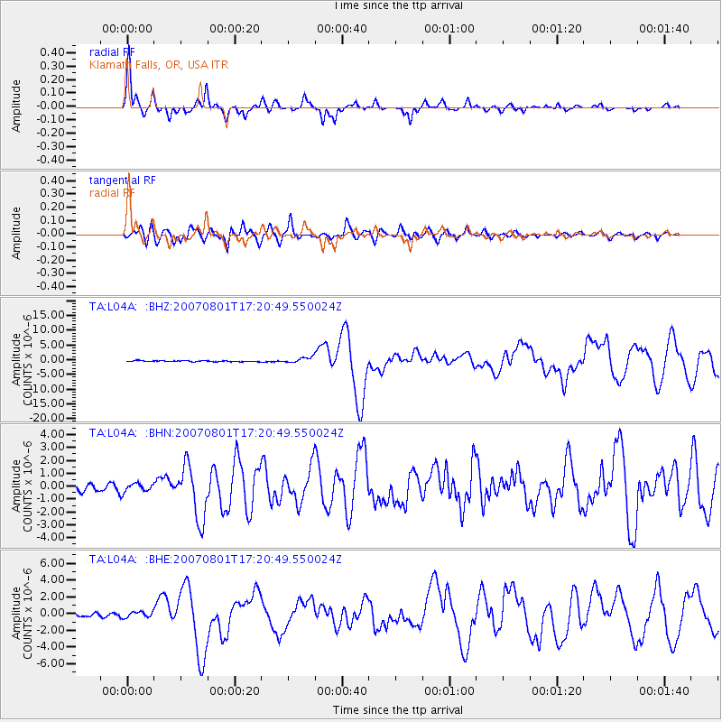
Signal To Noise
| Channel | StoN | STA | LTA |
| TA:L04A: :BHN:20070801T17:20:49.550024Z | 1.0990479 | 3.1026096E-7 | 2.8229977E-7 |
| TA:L04A: :BHE:20070801T17:20:49.550024Z | 1.7183335 | 3.391189E-7 | 1.9735339E-7 |
| TA:L04A: :BHZ:20070801T17:20:49.550024Z | 5.8986273 | 9.675275E-7 | 1.6402588E-7 |
| Arrivals |
| Ps | 4.9 SECOND |
| PpPs | 14 SECOND |
| PsPs/PpSs | 18 SECOND |


