You are here: Home > Network List > TA - USArray Transportable Network (new EarthScope stations) Stations List
> Station L04A Klamath Falls, OR, USA > Earthquake Result Viewer
L04A Klamath Falls, OR, USA - Earthquake Result Viewer
| Earthquake location: |
Southeast Of Loyalty Islands |
| Earthquake latitude/longitude: |
-21.5/170.9 |
| Earthquake time(UTC): |
2007/07/27 (208) 14:46:26 GMT |
| Earthquake Depth: |
10 km |
| Earthquake Magnitude: |
6.0 MB, 6.0 MS, 6.1 MW, 6.1 MW |
| Earthquake Catalog/Contributor: |
WHDF/NEIC |
|
| Network: |
TA USArray Transportable Network (new EarthScope stations) |
| Station: |
L04A Klamath Falls, OR, USA |
| Lat/Lon: |
42.17 N/121.89 W |
| Elevation: |
1336 m |
|
| Distance: |
88.5 deg |
| Az: |
43.261 deg |
| Baz: |
239.184 deg |
| Ray Param: |
0.04250603 |
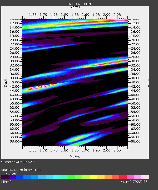
| Estimated Moho Depth: |
41.75 km |
| Estimated Crust Vp/Vs: |
1.69 |
| Assumed Crust Vp: |
6.597 km/s |
| Estimated Crust Vs: |
3.904 km/s |
| Estimated Crust Poisson's Ratio: |
0.23 |
|
| Radial Match: |
85.96627 % |
| Radial Bump: |
400 |
| Transverse Match: |
83.622284 % |
| Transverse Bump: |
400 |
| SOD ConfigId: |
2564 |
| Insert Time: |
2010-03-07 01:44:38.052 +0000 |
| GWidth: |
2.5 |
| Max Bumps: |
400 |
| Tol: |
0.001 |
|

Signal To Noise
| Channel | StoN | STA | LTA |
| TA:L04A: :BHN:20070727T14:58:48.098018Z | 0.7530349 | 7.868942E-8 | 1.0449638E-7 |
| TA:L04A: :BHE:20070727T14:58:48.098018Z | 1.1810875 | 1.4030658E-7 | 1.18794404E-7 |
| TA:L04A: :BHZ:20070727T14:58:48.098018Z | 3.2472806 | 3.3678253E-7 | 1.0371218E-7 |
| Arrivals |
| Ps | 4.5 SECOND |
| PpPs | 17 SECOND |
| PsPs/PpSs | 21 SECOND |


