You are here: Home > Network List > TA - USArray Transportable Network (new EarthScope stations) Stations List
> Station L04A Klamath Falls, OR, USA > Earthquake Result Viewer
L04A Klamath Falls, OR, USA - Earthquake Result Viewer
| Earthquake location: |
Sea Of Japan |
| Earthquake latitude/longitude: |
36.8/134.9 |
| Earthquake time(UTC): |
2007/07/16 (197) 14:17:37 GMT |
| Earthquake Depth: |
350 km |
| Earthquake Magnitude: |
6.2 MB, 6.8 MW, 6.8 MW |
| Earthquake Catalog/Contributor: |
WHDF/NEIC |
|
| Network: |
TA USArray Transportable Network (new EarthScope stations) |
| Station: |
L04A Klamath Falls, OR, USA |
| Lat/Lon: |
42.17 N/121.89 W |
| Elevation: |
1336 m |
|
| Distance: |
74.8 deg |
| Az: |
48.569 deg |
| Baz: |
305.953 deg |
| Ray Param: |
0.05108549 |
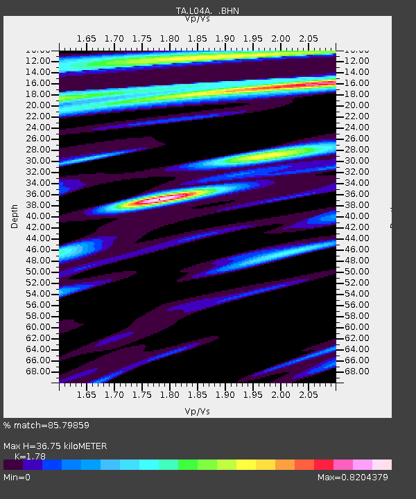
| Estimated Moho Depth: |
36.75 km |
| Estimated Crust Vp/Vs: |
1.78 |
| Assumed Crust Vp: |
6.597 km/s |
| Estimated Crust Vs: |
3.706 km/s |
| Estimated Crust Poisson's Ratio: |
0.27 |
|
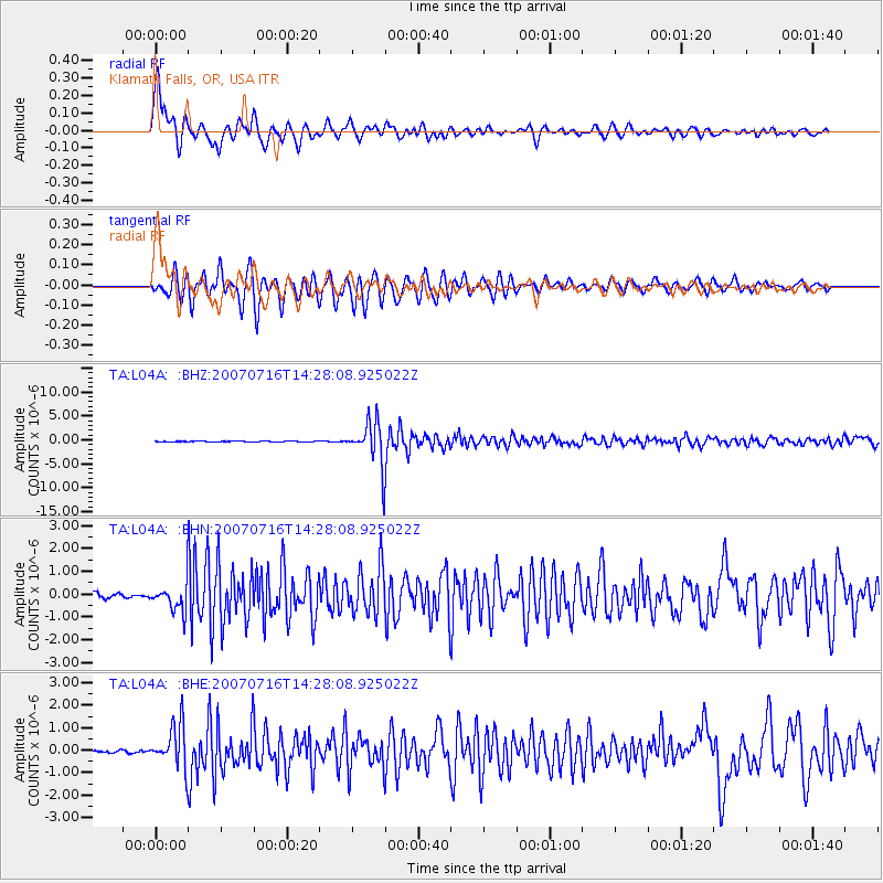
| Radial Match: |
85.79859 % |
| Radial Bump: |
400 |
| Transverse Match: |
77.718475 % |
| Transverse Bump: |
400 |
| SOD ConfigId: |
2564 |
| Insert Time: |
2010-03-07 01:44:41.305 +0000 |
| GWidth: |
2.5 |
| Max Bumps: |
400 |
| Tol: |
0.001 |
|
Signal To Noise
| Channel | StoN | STA | LTA |
| TA:L04A: :BHN:20070716T14:28:08.925022Z | 3.6509833 | 5.968497E-7 | 1.6347643E-7 |
| TA:L04A: :BHE:20070716T14:28:08.925022Z | 9.37867 | 9.566295E-7 | 1.02000556E-7 |
| TA:L04A: :BHZ:20070716T14:28:08.925022Z | 63.01132 | 4.58247E-6 | 7.272455E-8 |
| Arrivals |
| Ps | 4.5 SECOND |
| PpPs | 15 SECOND |
| PsPs/PpSs | 19 SECOND |


