You are here: Home > Network List > TA - USArray Transportable Network (new EarthScope stations) Stations List
> Station L04A Klamath Falls, OR, USA > Earthquake Result Viewer
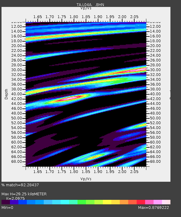
L04A Klamath Falls, OR, USA - Earthquake Result Viewer
| Earthquake location: |
Samoa Islands Region |
| Earthquake latitude/longitude: |
-16.6/-172.0 |
| Earthquake time(UTC): |
2006/09/28 (271) 06:22:09 GMT |
| Earthquake Depth: |
28 km |
| Earthquake Magnitude: |
6.5 MB, 6.6 MS, 6.9 MW, 6.7 MW |
| Earthquake Catalog/Contributor: |
WHDF/NEIC |
|
| Network: |
TA USArray Transportable Network (new EarthScope stations) |
| Station: |
L04A Klamath Falls, OR, USA |
| Lat/Lon: |
42.17 N/121.89 W |
| Elevation: |
1336 m |
|
| Distance: |
74.5 deg |
| Az: |
36.306 deg |
| Baz: |
229.8 deg |
| Ray Param: |
0.052244183 |
| Estimated Moho Depth: |
29.25 km |
| Estimated Crust Vp/Vs: |
2.10 |
| Assumed Crust Vp: |
6.597 km/s |
| Estimated Crust Vs: |
3.145 km/s |
| Estimated Crust Poisson's Ratio: |
0.35 |
|
| Radial Match: |
92.28437 % |
| Radial Bump: |
400 |
| Transverse Match: |
84.404434 % |
| Transverse Bump: |
400 |
| SOD ConfigId: |
2665 |
| Insert Time: |
2010-03-07 01:45:09.727 +0000 |
| GWidth: |
2.5 |
| Max Bumps: |
400 |
| Tol: |
0.001 |
|

Signal To Noise
| Channel | StoN | STA | LTA |
| TA:L04A: :BHN:20060928T06:33:14.573018Z | 9.24487 | 1.1659264E-6 | 1.2611603E-7 |
| TA:L04A: :BHE:20060928T06:33:14.573018Z | 8.802027 | 1.3713374E-6 | 1.557979E-7 |
| TA:L04A: :BHZ:20060928T06:33:14.573018Z | 49.951965 | 5.5234864E-6 | 1.1057596E-7 |
| Arrivals |
| Ps | 5.0 SECOND |
| PpPs | 13 SECOND |
| PsPs/PpSs | 18 SECOND |


