You are here: Home > Network List > KR - Kyrgyz Digital Network Stations List
> Station MNAS Manas, Kyrgyzstan > Earthquake Result Viewer
MNAS Manas, Kyrgyzstan - Earthquake Result Viewer
| Earthquake location: |
Halmahera, Indonesia |
| Earthquake latitude/longitude: |
-0.5/128.1 |
| Earthquake time(UTC): |
2019/07/14 (195) 09:10:50 GMT |
| Earthquake Depth: |
10 km |
| Earthquake Magnitude: |
7.3 Mww |
| Earthquake Catalog/Contributor: |
NEIC PDE/us |
|
| Network: |
KR Kyrgyz Digital Network |
| Station: |
MNAS Manas, Kyrgyzstan |
| Lat/Lon: |
42.49 N/72.50 E |
| Elevation: |
1465 m |
|
| Distance: |
65.7 deg |
| Az: |
317.96 deg |
| Baz: |
115.134 deg |
| Ray Param: |
0.05811003 |
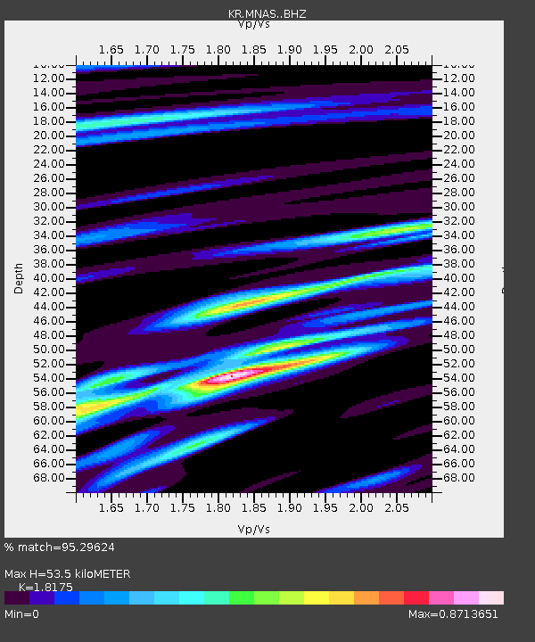
| Estimated Moho Depth: |
53.5 km |
| Estimated Crust Vp/Vs: |
1.82 |
| Assumed Crust Vp: |
6.316 km/s |
| Estimated Crust Vs: |
3.475 km/s |
| Estimated Crust Poisson's Ratio: |
0.28 |
|
| Radial Match: |
95.29624 % |
| Radial Bump: |
310 |
| Transverse Match: |
89.35429 % |
| Transverse Bump: |
400 |
| SOD ConfigId: |
19053131 |
| Insert Time: |
2019-07-28 09:13:26.922 +0000 |
| GWidth: |
2.5 |
| Max Bumps: |
400 |
| Tol: |
0.001 |
|

Signal To Noise
| Channel | StoN | STA | LTA |
| KR:MNAS: :BHZ:20190714T09:21:03.840007Z | 21.42219 | 1.2358631E-6 | 5.7690794E-8 |
| KR:MNAS: :BHN:20190714T09:21:03.840007Z | 4.323585 | 1.2834347E-7 | 2.9684506E-8 |
| KR:MNAS: :BHE:20190714T09:21:03.840007Z | 9.520998 | 5.2743457E-7 | 5.5396985E-8 |
| Arrivals |
| Ps | 7.2 SECOND |
| PpPs | 23 SECOND |
| PsPs/PpSs | 30 SECOND |


