You are here: Home > Network List > TA - USArray Transportable Network (new EarthScope stations) Stations List
> Station H03A Soap Creek Ranch, Albany, OR, USA > Earthquake Result Viewer
H03A Soap Creek Ranch, Albany, OR, USA - Earthquake Result Viewer

| Earthquake location: |
Southeast Of Loyalty Islands |
| Earthquake latitude/longitude: |
-21.1/169.3 |
| Earthquake time(UTC): |
2007/09/27 (270) 19:57:44 GMT |
| Earthquake Depth: |
9.0 km |
| Earthquake Magnitude: |
6.2 MB, 6.3 MS, 6.1 MW, 6.1 MW |
| Earthquake Catalog/Contributor: |
WHDF/NEIC |
|
| Network: |
TA USArray Transportable Network (new EarthScope stations) |
| Station: |
H03A Soap Creek Ranch, Albany, OR, USA |
| Lat/Lon: |
44.68 N/123.29 W |
| Elevation: |
214 m |
|
| Distance: |
89.7 deg |
| Az: |
41.207 deg |
| Baz: |
239.565 deg |
| Ray Param: |
0.041724905 |
| Estimated Moho Depth: |
44.0 km |
| Estimated Crust Vp/Vs: |
1.75 |
| Assumed Crust Vp: |
6.566 km/s |
| Estimated Crust Vs: |
3.741 km/s |
| Estimated Crust Poisson's Ratio: |
0.26 |
|
| Radial Match: |
89.90477 % |
| Radial Bump: |
380 |
| Transverse Match: |
77.844315 % |
| Transverse Bump: |
400 |
| SOD ConfigId: |
2564 |
| Insert Time: |
2010-03-07 02:02:05.354 +0000 |
| GWidth: |
2.5 |
| Max Bumps: |
400 |
| Tol: |
0.001 |
|
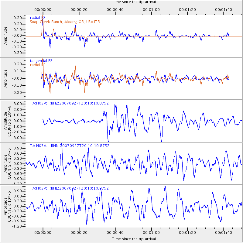
Signal To Noise
| Channel | StoN | STA | LTA |
| TA:H03A: :BHN:20070927T20:10:10.875Z | 1.4472182 | 2.0645521E-7 | 1.426566E-7 |
| TA:H03A: :BHE:20070927T20:10:10.875Z | 1.4338199 | 2.1769884E-7 | 1.5183137E-7 |
| TA:H03A: :BHZ:20070927T20:10:10.875Z | 2.916691 | 7.20396E-7 | 2.4699082E-7 |
| Arrivals |
| Ps | 5.2 SECOND |
| PpPs | 18 SECOND |
| PsPs/PpSs | 23 SECOND |


