
Station TA H03A - Soap Creek Ranch, Albany, OR, USA
Network: TA - USArray Transportable Network (new EarthScope stations)
Nearby stations (2 deg radius)
| Station | Name | (Lat, Lon) | Start / End | Elevation |
| H03A | Soap Creek Ranch, Albany, OR, USA | (44.68, -123.29) | 2005-11-10 / 2499-01-01 | 0.2 km |
| Crust2 Type: | L8,thin continental arc, Cordilleras, 0.5 km seds. |
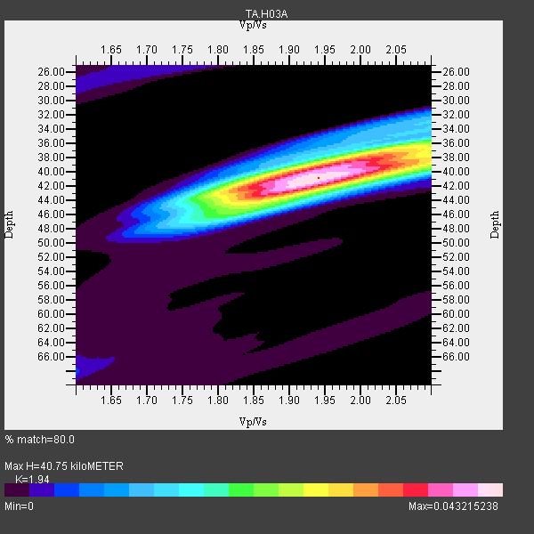
| Thickness Estimate: | 41 km |
| Thickness StdDev: | 0.9 km |
| Vp/Vs Estimate: | 1.94 |
| Vp/Vs StdDev: | 0.03 |
| Vs Estimate: | 3.385 km/s |
| Poisson's Ratio: | 0.32 |
| Peak Value: | 0.04 |
| Assumed Vp: | 6.566 km/s |
| Ps Weight: | 0.33333334 |
| PpPs Weight: | 0.33333334 |
| PsPs Weight: | 0.33333328 |
| Residual Complexity: | 0.616 |
| Nearby stations H: | +- |
| (2.0 deg) Vp/Vs: | +- |
22 with match > 90% ( 48.88889 %) and 45 with match > 80% ( 100.0 %) out of 45.
Download stack as xyz text file.
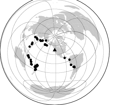
Azimuth Distribution of Events:
Prior Results for this Station
| Study | Thickness | Vp/Vs | Vp | Vs | Poissons Ratio | Extra |
| EARS | 41 km | 1.94 | 6.566 km/s | 3.385 km/s | 0.32 | |
| Crust2.0 | 34 km | 1.77 | 6.566 km/s | 3.707 km/s | 0.27 | L8,thin continental arc, Cordilleras, 0.5 km seds. |
| Global Maxima | 41 km | 1.94 | 6.566 km/s | 3.385 km/s | 0.32 | amp=0.043215238 |
| Local Maxima 1 | 38 km | 2.00 | 6.566 km/s | 3.291 km/s | 0.33 | amp=0.028166845 |
| Local Maxima 2 | 44 km | 1.84 | 6.566 km/s | 3.569 km/s | 0.29 | amp=0.022558711 |
| Local Maxima 3 | 36 km | 2.09 | 6.566 km/s | 3.138 km/s | 0.35 | amp=0.014844721 |
| Local Maxima 4 | 40 km | 2.08 | 6.566 km/s | 3.161 km/s | 0.35 | amp=0.013203629 |
| Predicted Arrivals for vertical incidence (zero ray parameter) | |
| Ps | 5.83 SECOND |
| PpPs | 18.25 SECOND |
| PsPs/PpSs | 24.08 SECOND |
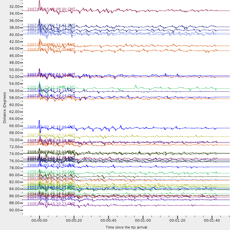
Events Processed for this Station
Download zip of receiver functions as SAC
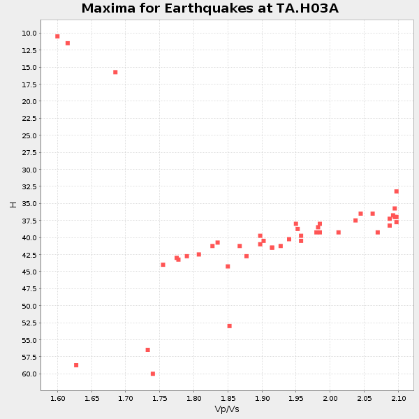
Plot maxima for each earthquake.
Events Used in the Stack
(45 events)| Radial Match | Distance | Baz | FERegion | Time | Lat/Lon | Depth | Magnitude |
| 98.780556 | 79.5 deg | 227.794 deg | Tonga Islands | 2006/05/03 15:26:40 GMT | (-20.2, -174.1) | 55 km | 7.2 MB, 7.8 MS, 7.9 MW, 7.9 MW |
| 98.54774 | 88.6 deg | 256.778 deg | Solomon Islands | 2007/04/01 20:39:56 GMT | (-8.5, 157.0) | 10 km | 6.8 MB, 7.9 MS, 8.1 MW, 7.7 ME |
| 97.58386 | 55.7 deg | 303.963 deg | Kuril Islands | 2006/11/15 11:14:13 GMT | (46.6, 153.3) | 10 km | 6.5 MB, 7.8 MS, 8.3 MW, 7.9 MW |
| 97.54999 | 82.5 deg | 131.394 deg | Northern Chile | 2007/11/14 15:40:50 GMT | (-22.2, -69.9) | 40 km | 6.7 MB, 7.4 MS, 7.7 MW, 7.4 ME |
| 97.52328 | 84.9 deg | 248.394 deg | Santa Cruz Islands | 2007/09/02 01:05:18 GMT | (-11.6, 165.8) | 35 km | 5.9 MB, 7.3 MS, 7.2 MW, 6.9 ME |
| 96.24071 | 77.6 deg | 288.613 deg | Volcano Islands, Japan Region | 2007/09/28 13:38:59 GMT | (22.0, 142.7) | 276 km | 6.7 MB, 7.4 MW, 7.4 MW |
| 96.18845 | 71.6 deg | 131.744 deg | Near Coast Of Peru | 2007/08/15 23:40:57 GMT | (-13.4, -76.6) | 39 km | 6.7 MB, 7.9 MS, 8.0 MW, 7.5 ME |
| 96.14027 | 86.6 deg | 244.339 deg | Vanuatu Islands | 2007/08/01 17:08:51 GMT | (-15.6, 167.7) | 120 km | 6.2 MB, 7.2 MW, 7.2 MW |
| 95.32066 | 91.6 deg | 224.951 deg | Kermadec Islands Region | 2006/05/16 10:39:23 GMT | (-31.8, -179.3) | 152 km | 6.8 MB, 7.4 MW, 7.4 MW |
| 95.10198 | 72.5 deg | 304.567 deg | Sea Of Japan | 2007/07/16 14:17:37 GMT | (36.8, 134.9) | 350 km | 6.2 MB, 6.8 MW, 6.8 MW |
| 94.58378 | 50.8 deg | 308.533 deg | Kamchatka Peninsula, Russia | 2007/05/30 20:22:12 GMT | (52.1, 157.3) | 116 km | 6.4 MB, 6.4 MW, 6.4 MW |
| 94.492 | 69.9 deg | 303.101 deg | Near West Coast Of Honshu, Japan | 2007/07/16 01:13:22 GMT | (37.5, 138.4) | 12 km | 6.5 MB, 6.4 MS, 6.6 MW, 6.5 MW |
| 94.29602 | 83.7 deg | 129.919 deg | Chile-Bolivia Border Region | 2005/11/17 19:26:56 GMT | (-22.3, -67.9) | 163 km | 6.0 MB, 6.9 MW, 6.8 MW |
| 93.705284 | 87.9 deg | 254.115 deg | Solomon Islands | 2007/08/16 08:39:27 GMT | (-9.8, 159.5) | 10 km | 6.1 MB, 6.7 MS, 6.4 MW |
| 93.62658 | 57.5 deg | 122.655 deg | Near West Coast Of Colombia | 2007/09/10 01:49:14 GMT | (3.0, -78.0) | 31 km | 6.1 MB, 6.7 MS, 6.8 MW |
| 93.50959 | 51.1 deg | 307.301 deg | Near East Coast Of Kamchatka | 2006/08/24 21:50:36 GMT | (51.1, 157.5) | 43 km | 5.9 MB, 6.2 MS, 6.5 MW, 6.5 MW |
| 93.49051 | 86.7 deg | 244.133 deg | Vanuatu Islands | 2006/08/07 22:18:54 GMT | (-15.8, 167.8) | 141 km | 6.0 MB, 6.8 MW, 6.8 MW |
| 93.36787 | 89.9 deg | 258.818 deg | Solomon Islands | 2007/06/28 02:52:09 GMT | (-8.0, 154.6) | 10 km | 6.3 MB, 6.7 MS, 6.7 MW, 6.7 MW |
| 92.55041 | 75.4 deg | 228.152 deg | Samoa Islands Region | 2006/09/28 06:22:09 GMT | (-16.6, -172.0) | 28 km | 6.5 MB, 6.6 MS, 6.9 MW, 6.7 MW |
| 91.78245 | 88.5 deg | 259.047 deg | Solomon Islands | 2006/09/01 10:18:51 GMT | (-6.8, 155.5) | 38 km | 6.3 MB, 6.7 MS, 6.8 MW, 6.7 MW |
| 91.69114 | 85.9 deg | 243.819 deg | Vanuatu Islands | 2007/07/15 09:27:34 GMT | (-15.4, 168.6) | 8.0 km | 6.0 MB, 5.8 MS, 6.1 MW, 6.0 MW |
| 90.772835 | 85.8 deg | 130.517 deg | Chile-Argentina Border Region | 2006/08/25 00:44:46 GMT | (-24.4, -67.0) | 184 km | 5.9 MB, 6.6 MW, 6.6 MW |
| 89.90477 | 89.7 deg | 239.565 deg | Southeast Of Loyalty Islands | 2007/09/27 19:57:44 GMT | (-21.1, 169.3) | 9.0 km | 6.2 MB, 6.3 MS, 6.1 MW, 6.1 MW |
| 89.570885 | 86.3 deg | 227.039 deg | South Of Fiji Islands | 2007/07/18 00:07:35 GMT | (-26.3, -177.7) | 10 km | 5.8 MB, 5.9 MS, 6.1 MW, 6.0 MW |
| 88.48515 | 36.4 deg | 298.731 deg | Andreanof Islands, Aleutian Is. | 2007/08/15 20:22:11 GMT | (50.3, -177.5) | 9.0 km | 6.3 MB, 6.2 MS, 6.4 MW, 5.9 ML |
| 88.218834 | 42.9 deg | 317.744 deg | Eastern Siberia, Russia | 2006/04/20 23:25:02 GMT | (60.9, 167.1) | 22 km | 6.8 MB, 7.6 MS, 7.6 MW, 7.3 MW |
| 87.90798 | 71.7 deg | 131.848 deg | Near Coast Of Peru | 2006/10/20 10:48:56 GMT | (-13.5, -76.7) | 23 km | 5.9 MB, 6.6 MS, 6.7 MW, 6.6 MW |
| 87.73695 | 77.3 deg | 304.031 deg | Kyushu, Japan | 2006/06/11 20:01:26 GMT | (33.1, 131.1) | 140 km | 5.9 MB, 6.3 MW, 6.3 MW |
| 87.18962 | 77.9 deg | 284.525 deg | Mariana Islands | 2007/10/31 03:30:17 GMT | (18.9, 145.4) | 223 km | 6.2 MB, 7.2 MW, 7.2 MW |
| 86.66968 | 54.7 deg | 304.02 deg | Kuril Islands | 2006/11/15 12:16:05 GMT | (47.1, 154.4) | 10 km | 5.7 MB |
| 85.760155 | 75.1 deg | 230.229 deg | Tonga Islands | 2006/07/07 07:26:12 GMT | (-15.2, -173.6) | 35 km | 5.7 MB, 5.9 MS, 6.0 MW, 6.0 MW |
| 84.55516 | 83.4 deg | 278.131 deg | South Of Mariana Islands | 2007/09/30 02:08:30 GMT | (10.5, 145.7) | 14 km | 6.4 MB, 7.1 MS, 6.9 MW, 6.9 MW |
| 83.52401 | 88.6 deg | 224.47 deg | Kermadec Islands Region | 2006/03/31 13:21:00 GMT | (-29.6, -176.8) | 17 km | 5.9 MB, 6.7 MS, 6.5 MW, 6.5 MW |
| 82.97109 | 76.9 deg | 286.52 deg | Mariana Islands | 2007/01/30 21:37:45 GMT | (21.0, 144.7) | 30 km | 6.3 MB, 6.5 MS, 6.6 MW, 6.5 MW |
| 82.34452 | 89.0 deg | 238.166 deg | Southeast Of Loyalty Islands | 2007/07/27 14:46:26 GMT | (-21.5, 170.9) | 10 km | 6.0 MB, 6.0 MS, 6.1 MW, 6.1 MW |
| 82.3056 | 71.8 deg | 131.893 deg | Near Coast Of Peru | 2007/08/19 01:22:40 GMT | (-13.6, -76.6) | 26 km | 5.9 MB, 5.4 MS, 5.8 MW, 5.5 ML |
| 82.235176 | 37.7 deg | 300.888 deg | Andreanof Islands, Aleutian Is. | 2007/08/02 03:21:42 GMT | (51.3, -180.0) | 21 km | 6.3 MB, 6.6 MS, 6.7 MW, 6.6 MW |
| 82.06806 | 30.2 deg | 301.132 deg | Fox Islands, Aleutian Islands | 2007/07/15 13:08:00 GMT | (52.5, -168.0) | 10 km | 5.8 MB, 5.9 MS, 6.1 MW, 6.0 MW |
| 81.35288 | 81.4 deg | 231.104 deg | Fiji Islands Region | 2006/01/02 22:13:40 GMT | (-19.9, -178.2) | 583 km | 6.5 MB, 7.2 MW, 7.1 MW |
| 81.299736 | 58.0 deg | 304.6 deg | Kuril Islands | 2007/09/03 16:14:53 GMT | (45.8, 150.1) | 94 km | 6.3 MB, 6.2 MW, 6.2 ME |
| 81.276115 | 37.3 deg | 300.59 deg | Andreanof Islands, Aleutian Is. | 2006/07/08 20:40:00 GMT | (51.2, -179.3) | 22 km | 6.2 MB, 6.4 MS, 6.6 MW, 6.6 MW |
| 81.13458 | 35.3 deg | 301.009 deg | Andreanof Islands, Aleutian Is. | 2007/07/13 21:54:43 GMT | (51.8, -176.3) | 35 km | 5.7 MB, 5.6 MS, 6.0 MW, 5.9 MW |
| 80.58225 | 85.4 deg | 230.277 deg | South Of Fiji Islands | 2006/02/26 03:08:27 GMT | (-23.6, -180.0) | 535 km | 5.9 MB, 6.4 MW, 6.4 MW |
| 80.41118 | 67.3 deg | 301.526 deg | Near East Coast Of Honshu, Japan | 2005/12/02 13:13:09 GMT | (38.1, 142.1) | 29 km | 6.1 MB, 6.3 MS, 6.5 MW, 6.4 MW |
| 80.047264 | 41.3 deg | 127.747 deg | Near Coast Of Guatemala | 2007/06/08 13:32:00 GMT | (13.8, -90.8) | 48 km | 5.5 MB, 5.4 MS, 5.8 MW, 5.8 MW |
Losers
(0 events)| Radial Match | Distance | Baz | FERegion | Time | Lat/Lon | Depth | Magnitude | Reason |
