You are here: Home > Network List > TA - USArray Transportable Network (new EarthScope stations) Stations List
> Station H03A Soap Creek Ranch, Albany, OR, USA > Earthquake Result Viewer
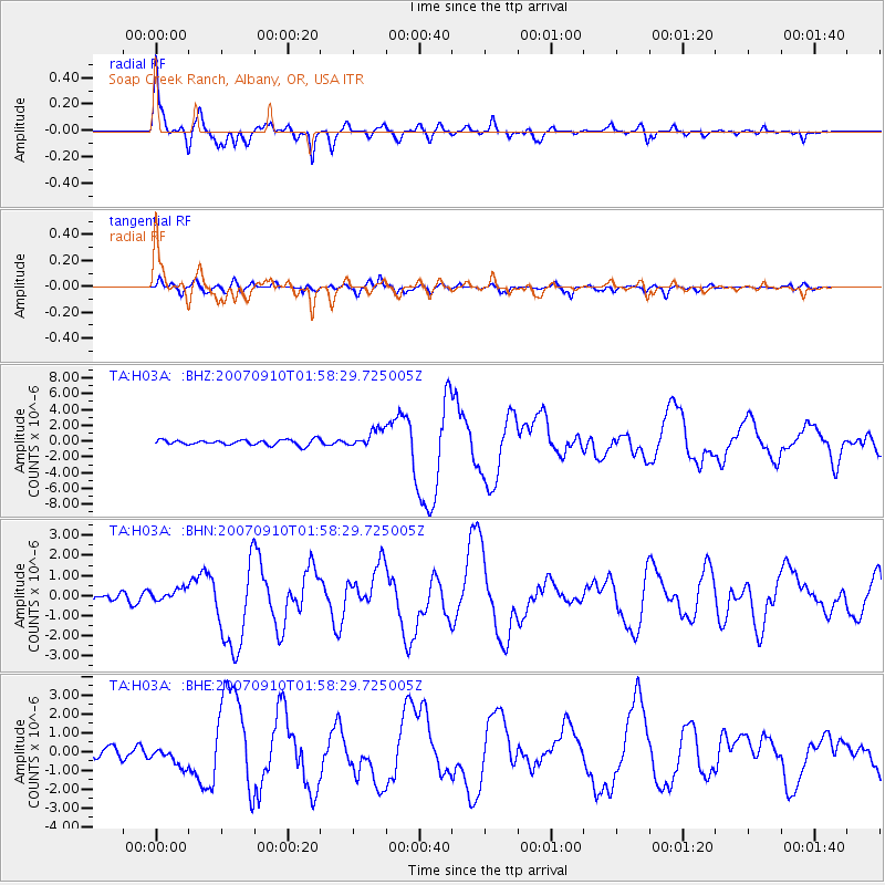
H03A Soap Creek Ranch, Albany, OR, USA - Earthquake Result Viewer

| Earthquake location: |
Near West Coast Of Colombia |
| Earthquake latitude/longitude: |
3.0/-78.0 |
| Earthquake time(UTC): |
2007/09/10 (253) 01:49:14 GMT |
| Earthquake Depth: |
31 km |
| Earthquake Magnitude: |
6.1 MB, 6.7 MS, 6.8 MW |
| Earthquake Catalog/Contributor: |
WHDF/NEIC |
|
| Network: |
TA USArray Transportable Network (new EarthScope stations) |
| Station: |
H03A Soap Creek Ranch, Albany, OR, USA |
| Lat/Lon: |
44.68 N/123.29 W |
| Elevation: |
214 m |
|
| Distance: |
57.5 deg |
| Az: |
323.024 deg |
| Baz: |
122.655 deg |
| Ray Param: |
0.06339317 |
| Estimated Moho Depth: |
38.25 km |
| Estimated Crust Vp/Vs: |
2.09 |
| Assumed Crust Vp: |
6.566 km/s |
| Estimated Crust Vs: |
3.145 km/s |
| Estimated Crust Poisson's Ratio: |
0.35 |
|
| Radial Match: |
93.62658 % |
| Radial Bump: |
372 |
| Transverse Match: |
79.438866 % |
| Transverse Bump: |
400 |
| SOD ConfigId: |
2564 |
| Insert Time: |
2010-03-07 02:02:07.339 +0000 |
| GWidth: |
2.5 |
| Max Bumps: |
400 |
| Tol: |
0.001 |
|
Signal To Noise
| Channel | StoN | STA | LTA |
| TA:H03A: :BHN:20070910T01:58:29.725005Z | 1.4540699 | 3.1776784E-7 | 2.1853684E-7 |
| TA:H03A: :BHE:20070910T01:58:29.725005Z | 2.647344 | 5.167263E-7 | 1.9518667E-7 |
| TA:H03A: :BHZ:20070910T01:58:29.725005Z | 3.2881582 | 1.1131955E-6 | 3.385468E-7 |
| Arrivals |
| Ps | 6.6 SECOND |
| PpPs | 17 SECOND |
| PsPs/PpSs | 24 SECOND |


