You are here: Home > Network List > TA - USArray Transportable Network (new EarthScope stations) Stations List
> Station F07A Phinny Hill Vineyards, Prosser, WA, USA > Earthquake Result Viewer
F07A Phinny Hill Vineyards, Prosser, WA, USA - Earthquake Result Viewer
| Earthquake location: |
Windward Islands |
| Earthquake latitude/longitude: |
15.0/-61.3 |
| Earthquake time(UTC): |
2007/11/29 (333) 19:00:19 GMT |
| Earthquake Depth: |
148 km |
| Earthquake Magnitude: |
6.9 MB, 7.4 MW, 7.4 MW |
| Earthquake Catalog/Contributor: |
WHDF/NEIC |
|
| Network: |
TA USArray Transportable Network (new EarthScope stations) |
| Station: |
F07A Phinny Hill Vineyards, Prosser, WA, USA |
| Lat/Lon: |
45.90 N/119.93 W |
| Elevation: |
227 m |
|
| Distance: |
57.7 deg |
| Az: |
315.094 deg |
| Baz: |
102.329 deg |
| Ray Param: |
0.06288049 |
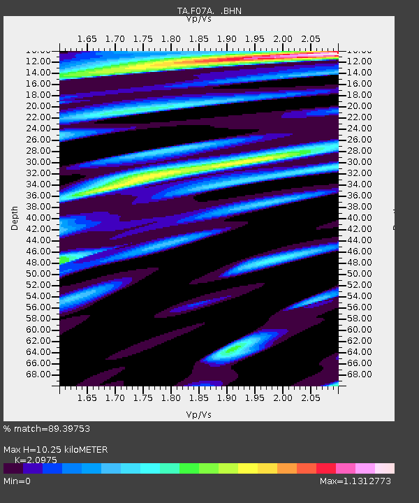
| Estimated Moho Depth: |
10.25 km |
| Estimated Crust Vp/Vs: |
2.10 |
| Assumed Crust Vp: |
6.571 km/s |
| Estimated Crust Vs: |
3.133 km/s |
| Estimated Crust Poisson's Ratio: |
0.35 |
|
| Radial Match: |
89.39753 % |
| Radial Bump: |
400 |
| Transverse Match: |
69.42299 % |
| Transverse Bump: |
400 |
| SOD ConfigId: |
2564 |
| Insert Time: |
2010-03-07 02:03:35.647 +0000 |
| GWidth: |
2.5 |
| Max Bumps: |
400 |
| Tol: |
0.001 |
|

Signal To Noise
| Channel | StoN | STA | LTA |
| TA:F07A: :BHN:20071129T19:09:23.925024Z | 3.1024804 | 1.002446E-6 | 3.2311112E-7 |
| TA:F07A: :BHE:20071129T19:09:23.925024Z | 9.026152 | 3.0977446E-6 | 3.4319658E-7 |
| TA:F07A: :BHZ:20071129T19:09:23.925024Z | 16.650866 | 7.1534623E-6 | 4.2961503E-7 |
| Arrivals |
| Ps | 1.8 SECOND |
| PpPs | 4.6 SECOND |
| PsPs/PpSs | 6.4 SECOND |


