
Station TA F07A - Phinny Hill Vineyards, Prosser, WA, USA
Network: TA - USArray Transportable Network (new EarthScope stations)
Nearby stations (2 deg radius)
| Station | Name | (Lat, Lon) | Start / End | Elevation |
| F07A | Phinny Hill Vineyards, Prosser, WA, USA | (45.90, -119.93) | 2006-08-27 / 2499-01-01 | 0.2 km |
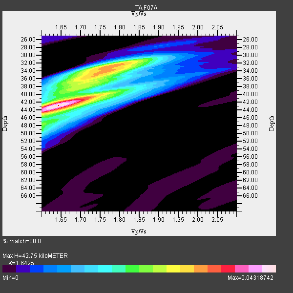
| Crust2 Type: | Q9,orogen/41km no ice, cordilleras, 0.25 km seds. |
| Thickness Estimate: | 43 km |
| Thickness StdDev: | 2.2 km |
| Vp/Vs Estimate: | 1.64 |
| Vp/Vs StdDev: | 0.03 |
| Vs Estimate: | 4.0 km/s |
| Poisson's Ratio: | 0.21 |
| Peak Value: | 0.04 |
| Assumed Vp: | 6.571 km/s |
| Ps Weight: | 0.33333334 |
| PpPs Weight: | 0.33333334 |
| PsPs Weight: | 0.33333328 |
| Residual Complexity: | 0.765 |
| Nearby stations H: | 43 km +- 0.0 km |
| (2.0 deg) Vp/Vs: | 1.65 +- 0.02 |
11 with match > 90% ( 33.333332 %) and 33 with match > 80% ( 100.0 %) out of 33.
Download stack as xyz text file.
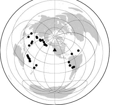
Azimuth Distribution of Events:
Prior Results for this Station
| Study | Thickness | Vp/Vs | Vp | Vs | Poissons Ratio | Extra |
| EARS | 43 km | 1.64 | 6.571 km/s | 4.0 km/s | 0.21 | |
| Crust2.0 | 41 km | 1.76 | 6.571 km/s | 3.735 km/s | 0.26 | Q9,orogen/41km no ice, cordilleras, 0.25 km seds. |
| Global Maxima | 43 km | 1.64 | 6.571 km/s | 4.0 km/s | 0.21 | amp=0.04318742 |
| Local Maxima 1 | 32 km | 1.78 | 6.571 km/s | 3.691 km/s | 0.27 | amp=0.031164477 |
| Local Maxima 2 | 36 km | 1.72 | 6.571 km/s | 3.826 km/s | 0.24 | amp=0.022798961 |
| Local Maxima 3 | 40 km | 1.76 | 6.571 km/s | 3.728 km/s | 0.26 | amp=0.017448105 |
| Local Maxima 4 | 45 km | 1.61 | 6.571 km/s | 4.075 km/s | 0.19 | amp=0.014512741 |
| Predicted Arrivals for vertical incidence (zero ray parameter) | |
| Ps | 4.18 SECOND |
| PpPs | 17.19 SECOND |
| PsPs/PpSs | 21.37 SECOND |
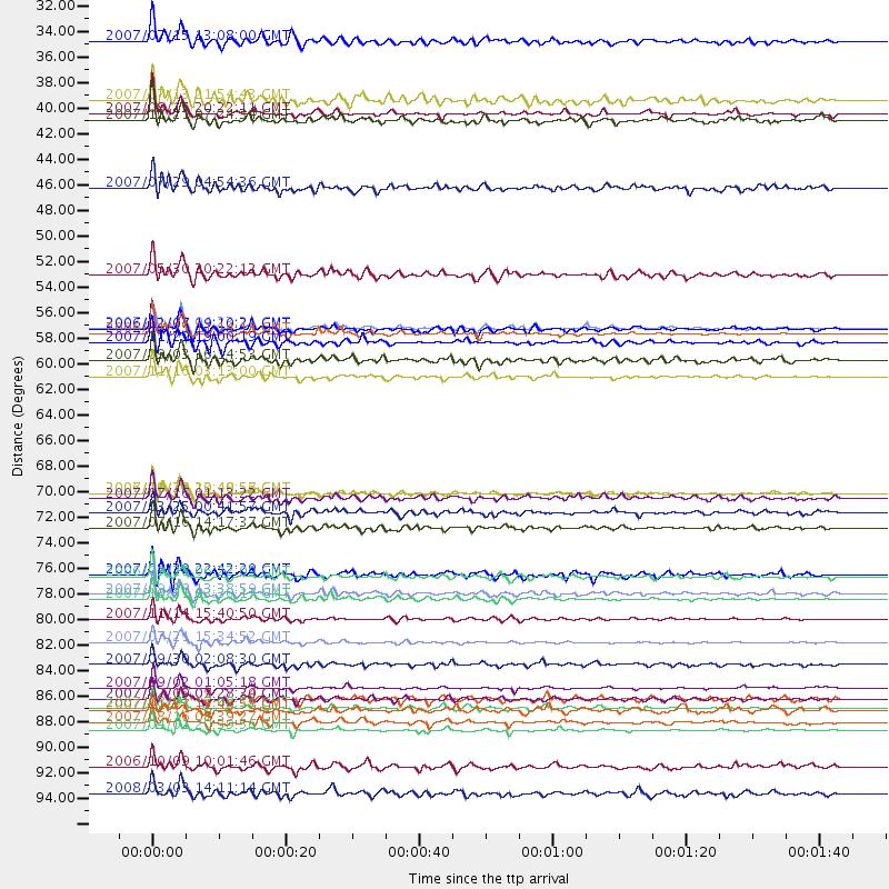
Events Processed for this Station
Download zip of receiver functions as SAC
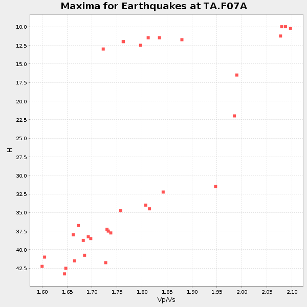
Plot maxima for each earthquake.
Events Used in the Stack
(33 events)| Radial Match | Distance | Baz | FERegion | Time | Lat/Lon | Depth | Magnitude |
| 99.21324 | 57.0 deg | 304.783 deg | Kuril Islands | 2006/11/15 11:14:13 GMT | (46.6, 153.3) | 10 km | 6.5 MB, 7.8 MS, 8.3 MW, 7.9 MW |
| 98.17988 | 70.7 deg | 134.984 deg | Near Coast Of Peru | 2007/08/15 23:40:57 GMT | (-13.4, -76.6) | 39 km | 6.7 MB, 7.9 MS, 8.0 MW, 7.5 ME |
| 97.87428 | 87.6 deg | 250.757 deg | Santa Cruz Islands | 2007/09/02 01:05:18 GMT | (-11.6, 165.8) | 35 km | 5.9 MB, 7.3 MS, 7.2 MW, 6.9 ME |
| 97.34462 | 91.2 deg | 259.161 deg | Solomon Islands | 2007/04/01 20:39:56 GMT | (-8.5, 157.0) | 10 km | 6.8 MB, 7.9 MS, 8.1 MW, 7.7 ME |
| 96.697266 | 81.6 deg | 134.127 deg | Northern Chile | 2007/11/14 15:40:50 GMT | (-22.2, -69.9) | 40 km | 6.7 MB, 7.4 MS, 7.7 MW, 7.4 ME |
| 96.45697 | 89.3 deg | 246.718 deg | Vanuatu Islands | 2007/08/01 17:08:51 GMT | (-15.6, 167.7) | 120 km | 6.2 MB, 7.2 MW, 7.2 MW |
| 96.19019 | 56.4 deg | 303.859 deg | East Of Kuril Islands | 2007/01/13 04:23:21 GMT | (46.2, 154.5) | 10 km | 7.3 MB, 8.2 MS, 8.1 MW, 7.9 MW |
| 95.02196 | 88.6 deg | 229.464 deg | South Of Fiji Islands | 2007/12/09 07:28:20 GMT | (-26.0, -177.5) | 152 km | 7.0 MB, 7.8 MW, 7.7 MW |
| 91.436356 | 51.9 deg | 308.964 deg | Kamchatka Peninsula, Russia | 2007/05/30 20:22:12 GMT | (52.1, 157.3) | 116 km | 6.4 MB, 6.4 MW, 6.4 MW |
| 91.261635 | 79.9 deg | 286.553 deg | Mariana Islands | 2007/10/31 03:30:17 GMT | (18.9, 145.4) | 223 km | 6.2 MB, 7.2 MW, 7.2 MW |
| 90.14834 | 31.6 deg | 299.751 deg | Fox Islands, Aleutian Islands | 2007/07/15 13:08:00 GMT | (52.5, -168.0) | 10 km | 5.8 MB, 5.9 MS, 6.1 MW, 6.0 MW |
| 89.99487 | 60.7 deg | 129.834 deg | Peru-Ecuador Border Region | 2007/11/16 03:13:00 GMT | (-2.3, -77.8) | 123 km | 6.3 MB, 6.8 MW, 6.7 MW |
| 89.83952 | 77.8 deg | 91.042 deg | Central Mid-Atlantic Ridge | 2007/08/20 22:42:29 GMT | (8.0, -39.2) | 10 km | 6.3 MB, 6.4 MS, 6.5 MW |
| 89.66022 | 37.9 deg | 298.206 deg | Andreanof Islands, Aleutian Is. | 2007/08/15 20:22:11 GMT | (50.3, -177.5) | 9.0 km | 6.3 MB, 6.2 MS, 6.4 MW, 5.9 ML |
| 89.58585 | 90.5 deg | 256.491 deg | Solomon Islands | 2007/08/16 08:39:27 GMT | (-9.8, 159.5) | 10 km | 6.1 MB, 6.7 MS, 6.4 MW |
| 89.39753 | 57.7 deg | 102.329 deg | Windward Islands | 2007/11/29 19:00:19 GMT | (15.0, -61.3) | 148 km | 6.9 MB, 7.4 MW, 7.4 MW |
| 89.194374 | 79.5 deg | 290.603 deg | Volcano Islands, Japan Region | 2007/09/28 13:38:59 GMT | (22.0, 142.7) | 276 km | 6.7 MB, 7.4 MW, 7.4 MW |
| 89.009476 | 70.8 deg | 135.088 deg | Near Coast Of Peru | 2006/10/20 10:48:56 GMT | (-13.5, -76.7) | 23 km | 5.9 MB, 6.6 MS, 6.7 MW, 6.6 MW |
| 88.99952 | 56.6 deg | 303.833 deg | East Of Kuril Islands | 2006/12/07 19:10:21 GMT | (46.2, 154.4) | 16 km | 6.3 MB, 6.1 MS, 6.3 MW, 6.3 MW |
| 88.93672 | 88.5 deg | 246.197 deg | Vanuatu Islands | 2007/07/15 09:27:34 GMT | (-15.4, 168.6) | 8.0 km | 6.0 MB, 5.8 MS, 6.1 MW, 6.0 MW |
| 88.40082 | 78.0 deg | 230.683 deg | Samoa Islands Region | 2006/09/28 06:22:09 GMT | (-16.6, -172.0) | 28 km | 6.5 MB, 6.6 MS, 6.9 MW, 6.7 MW |
| 88.16884 | 59.2 deg | 305.542 deg | Kuril Islands | 2007/09/03 16:14:53 GMT | (45.8, 150.1) | 94 km | 6.3 MB, 6.2 MW, 6.2 ME |
| 87.97051 | 71.2 deg | 304.66 deg | Near West Coast Of Honshu, Japan | 2007/07/16 01:13:22 GMT | (37.5, 138.4) | 12 km | 6.5 MB, 6.4 MS, 6.6 MW, 6.5 MW |
| 87.875175 | 36.7 deg | 300.286 deg | Andreanof Islands, Aleutian Is. | 2007/07/13 21:54:43 GMT | (51.8, -176.3) | 35 km | 5.7 MB, 5.6 MS, 6.0 MW, 5.9 MW |
| 87.4229 | 73.8 deg | 306.232 deg | Sea Of Japan | 2007/07/16 14:17:37 GMT | (36.8, 134.9) | 350 km | 6.2 MB, 6.8 MW, 6.8 MW |
| 86.10583 | 83.6 deg | 130.877 deg | Jujuy Province, Argentina | 2007/07/21 15:34:52 GMT | (-22.2, -65.8) | 290 km | 5.8 MB, 6.4 MW, 6.3 MW |
| 85.52843 | 44.4 deg | 306.693 deg | Komandorskiye Ostrova Region | 2007/07/29 04:54:36 GMT | (53.6, 169.7) | 26 km | 6.0 MB, 5.5 MS, 5.9 MW, 5.8 MW |
| 84.43117 | 85.6 deg | 280.363 deg | South Of Mariana Islands | 2007/09/30 02:08:30 GMT | (10.5, 145.7) | 14 km | 6.4 MB, 7.1 MS, 6.9 MW, 6.9 MW |
| 83.71512 | 96.7 deg | 296.846 deg | Philippine Islands Region | 2008/03/03 14:11:14 GMT | (13.4, 125.6) | 24 km | 6.4 MB, 6.9 MW, 6.8 MW |
| 82.85622 | 94.4 deg | 305.612 deg | Philippine Islands Region | 2006/10/09 10:01:46 GMT | (20.7, 120.0) | 10 km | 6.0 MB, 5.9 MS, 6.3 MW, 6.1 MW |
| 80.99607 | 72.4 deg | 305.594 deg | Near West Coast Of Honshu, Japan | 2007/03/25 00:41:57 GMT | (37.3, 136.6) | 8.0 km | 6.1 MB, 6.8 MS, 6.7 MW, 6.6 MW |
| 80.93217 | 38.5 deg | 300.223 deg | Andreanof Islands, Aleutian Is. | 2007/12/21 07:24:34 GMT | (51.4, -179.0) | 30 km | 6.1 MB, 6.2 MW, 6.3 ML |
| 80.823784 | 89.5 deg | 253.807 deg | Solomon Islands | 2007/11/27 11:49:58 GMT | (-10.9, 162.1) | 16 km | 5.9 MB, 6.7 MS, 6.6 MW, 6.4 MW |
Losers
(0 events)| Radial Match | Distance | Baz | FERegion | Time | Lat/Lon | Depth | Magnitude | Reason |
