You are here: Home > Network List > TA - USArray Transportable Network (new EarthScope stations) Stations List
> Station F07A Phinny Hill Vineyards, Prosser, WA, USA > Earthquake Result Viewer
F07A Phinny Hill Vineyards, Prosser, WA, USA - Earthquake Result Viewer
| Earthquake location: |
Peru-Ecuador Border Region |
| Earthquake latitude/longitude: |
-2.3/-77.8 |
| Earthquake time(UTC): |
2007/11/16 (320) 03:13:00 GMT |
| Earthquake Depth: |
123 km |
| Earthquake Magnitude: |
6.3 MB, 6.8 MW, 6.7 MW |
| Earthquake Catalog/Contributor: |
WHDF/NEIC |
|
| Network: |
TA USArray Transportable Network (new EarthScope stations) |
| Station: |
F07A Phinny Hill Vineyards, Prosser, WA, USA |
| Lat/Lon: |
45.90 N/119.93 W |
| Elevation: |
227 m |
|
| Distance: |
60.7 deg |
| Az: |
327.539 deg |
| Baz: |
129.834 deg |
| Ray Param: |
0.060985446 |
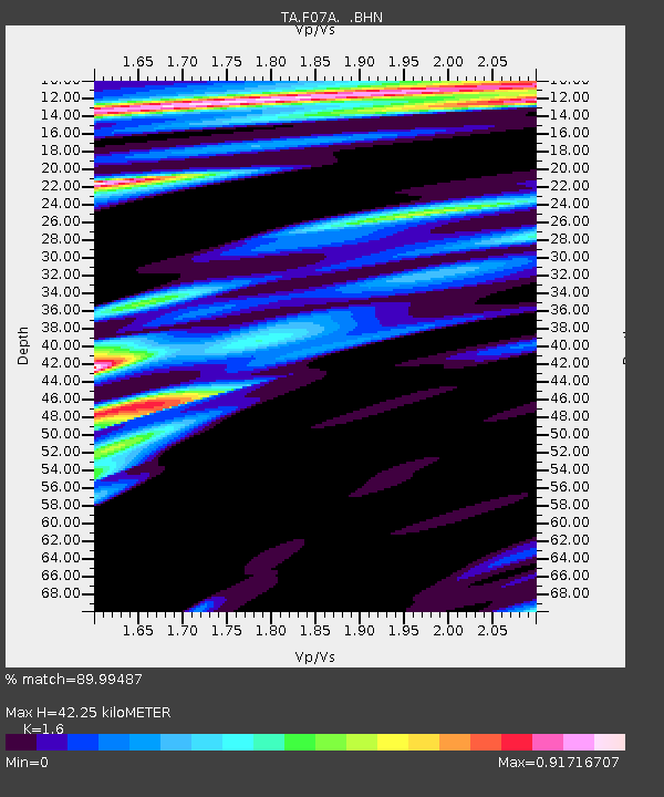
| Estimated Moho Depth: |
42.25 km |
| Estimated Crust Vp/Vs: |
1.60 |
| Assumed Crust Vp: |
6.571 km/s |
| Estimated Crust Vs: |
4.107 km/s |
| Estimated Crust Poisson's Ratio: |
0.18 |
|
| Radial Match: |
89.99487 % |
| Radial Bump: |
400 |
| Transverse Match: |
64.82985 % |
| Transverse Bump: |
400 |
| SOD ConfigId: |
2564 |
| Insert Time: |
2010-03-07 02:03:41.961 +0000 |
| GWidth: |
2.5 |
| Max Bumps: |
400 |
| Tol: |
0.001 |
|
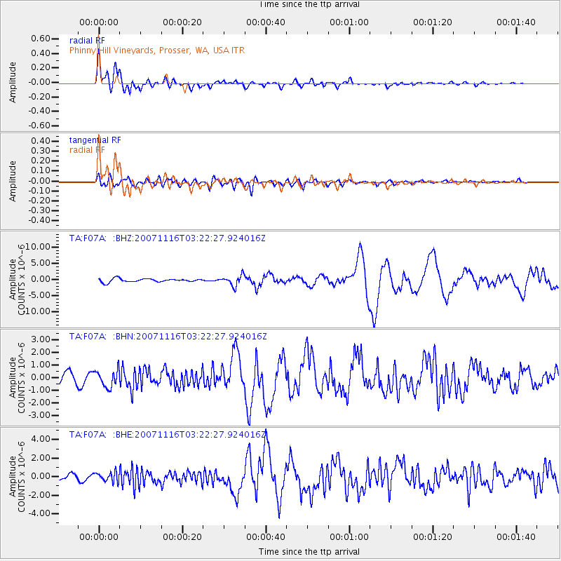
Signal To Noise
| Channel | StoN | STA | LTA |
| TA:F07A: :BHN:20071116T03:22:27.924016Z | 1.8330909 | 6.7350663E-7 | 3.6741585E-7 |
| TA:F07A: :BHE:20071116T03:22:27.924016Z | 1.0436468 | 5.033354E-7 | 4.822852E-7 |
| TA:F07A: :BHZ:20071116T03:22:27.924016Z | 3.1127424 | 1.626776E-6 | 5.226182E-7 |
| Arrivals |
| Ps | 4.1 SECOND |
| PpPs | 16 SECOND |
| PsPs/PpSs | 20 SECOND |


