You are here: Home > Network List > TA - USArray Transportable Network (new EarthScope stations) Stations List
> Station F07A Phinny Hill Vineyards, Prosser, WA, USA > Earthquake Result Viewer
F07A Phinny Hill Vineyards, Prosser, WA, USA - Earthquake Result Viewer
| Earthquake location: |
South Of Mariana Islands |
| Earthquake latitude/longitude: |
10.5/145.7 |
| Earthquake time(UTC): |
2007/09/30 (273) 02:08:30 GMT |
| Earthquake Depth: |
14 km |
| Earthquake Magnitude: |
6.4 MB, 7.1 MS, 6.9 MW, 6.9 MW |
| Earthquake Catalog/Contributor: |
WHDF/NEIC |
|
| Network: |
TA USArray Transportable Network (new EarthScope stations) |
| Station: |
F07A Phinny Hill Vineyards, Prosser, WA, USA |
| Lat/Lon: |
45.90 N/119.93 W |
| Elevation: |
227 m |
|
| Distance: |
85.6 deg |
| Az: |
44.301 deg |
| Baz: |
280.363 deg |
| Ray Param: |
0.04464745 |
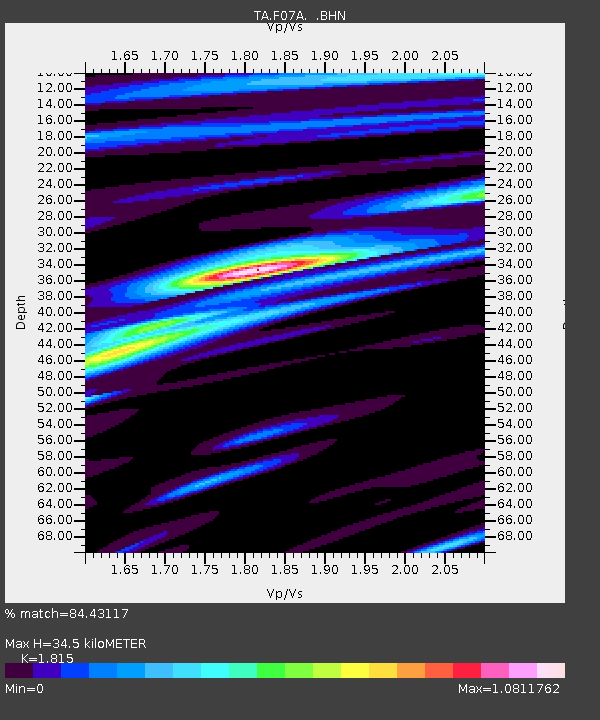
| Estimated Moho Depth: |
34.5 km |
| Estimated Crust Vp/Vs: |
1.82 |
| Assumed Crust Vp: |
6.571 km/s |
| Estimated Crust Vs: |
3.62 km/s |
| Estimated Crust Poisson's Ratio: |
0.28 |
|
| Radial Match: |
84.43117 % |
| Radial Bump: |
400 |
| Transverse Match: |
75.597885 % |
| Transverse Bump: |
400 |
| SOD ConfigId: |
2564 |
| Insert Time: |
2010-03-07 02:03:50.256 +0000 |
| GWidth: |
2.5 |
| Max Bumps: |
400 |
| Tol: |
0.001 |
|

Signal To Noise
| Channel | StoN | STA | LTA |
| TA:F07A: :BHN:20070930T02:20:36.425005Z | 0.9255538 | 1.8189591E-7 | 1.9652657E-7 |
| TA:F07A: :BHE:20070930T02:20:36.425005Z | 1.2148376 | 1.9045062E-7 | 1.5677044E-7 |
| TA:F07A: :BHZ:20070930T02:20:36.425005Z | 3.0586536 | 5.5612503E-7 | 1.8182021E-7 |
| Arrivals |
| Ps | 4.4 SECOND |
| PpPs | 14 SECOND |
| PsPs/PpSs | 19 SECOND |


