You are here: Home > Network List > TA - USArray Transportable Network (new EarthScope stations) Stations List
> Station F07A Phinny Hill Vineyards, Prosser, WA, USA > Earthquake Result Viewer
F07A Phinny Hill Vineyards, Prosser, WA, USA - Earthquake Result Viewer
| Earthquake location: |
Philippine Islands Region |
| Earthquake latitude/longitude: |
20.7/120.0 |
| Earthquake time(UTC): |
2006/10/09 (282) 10:01:46 GMT |
| Earthquake Depth: |
10 km |
| Earthquake Magnitude: |
6.0 MB, 5.9 MS, 6.3 MW, 6.1 MW |
| Earthquake Catalog/Contributor: |
WHDF/NEIC |
|
| Network: |
TA USArray Transportable Network (new EarthScope stations) |
| Station: |
F07A Phinny Hill Vineyards, Prosser, WA, USA |
| Lat/Lon: |
45.90 N/119.93 W |
| Elevation: |
227 m |
|
| Distance: |
94.4 deg |
| Az: |
37.319 deg |
| Baz: |
305.612 deg |
| Ray Param: |
0.041053597 |
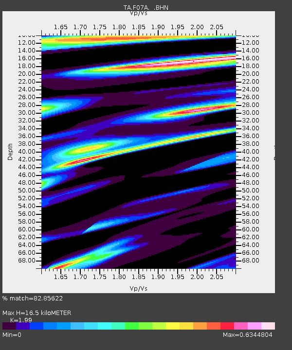
| Estimated Moho Depth: |
16.5 km |
| Estimated Crust Vp/Vs: |
1.99 |
| Assumed Crust Vp: |
6.571 km/s |
| Estimated Crust Vs: |
3.302 km/s |
| Estimated Crust Poisson's Ratio: |
0.33 |
|
| Radial Match: |
82.85622 % |
| Radial Bump: |
400 |
| Transverse Match: |
67.84915 % |
| Transverse Bump: |
400 |
| SOD ConfigId: |
2665 |
| Insert Time: |
2010-03-07 02:04:15.443 +0000 |
| GWidth: |
2.5 |
| Max Bumps: |
400 |
| Tol: |
0.001 |
|

Signal To Noise
| Channel | StoN | STA | LTA |
| TA:F07A: :BHN:20061009T10:14:34.975005Z | 1.1366144 | 1.4947695E-7 | 1.3151067E-7 |
| TA:F07A: :BHE:20061009T10:14:34.975005Z | 2.7402804 | 2.6885166E-7 | 9.811101E-8 |
| TA:F07A: :BHZ:20061009T10:14:34.975005Z | 2.2506268 | 4.899291E-7 | 2.1768561E-7 |
| Arrivals |
| Ps | 2.5 SECOND |
| PpPs | 7.4 SECOND |
| PsPs/PpSs | 9.9 SECOND |


