You are here: Home > Network List > TA - USArray Transportable Network (new EarthScope stations) Stations List
> Station F07A Phinny Hill Vineyards, Prosser, WA, USA > Earthquake Result Viewer
F07A Phinny Hill Vineyards, Prosser, WA, USA - Earthquake Result Viewer

| Earthquake location: |
Jujuy Province, Argentina |
| Earthquake latitude/longitude: |
-22.2/-65.8 |
| Earthquake time(UTC): |
2007/07/21 (202) 15:34:52 GMT |
| Earthquake Depth: |
290 km |
| Earthquake Magnitude: |
5.8 MB, 6.4 MW, 6.3 MW |
| Earthquake Catalog/Contributor: |
WHDF/NEIC |
|
| Network: |
TA USArray Transportable Network (new EarthScope stations) |
| Station: |
F07A Phinny Hill Vineyards, Prosser, WA, USA |
| Lat/Lon: |
45.90 N/119.93 W |
| Elevation: |
227 m |
|
| Distance: |
83.6 deg |
| Az: |
325.278 deg |
| Baz: |
130.877 deg |
| Ray Param: |
0.045313995 |
| Estimated Moho Depth: |
11.25 km |
| Estimated Crust Vp/Vs: |
2.08 |
| Assumed Crust Vp: |
6.571 km/s |
| Estimated Crust Vs: |
3.163 km/s |
| Estimated Crust Poisson's Ratio: |
0.35 |
|
| Radial Match: |
86.10583 % |
| Radial Bump: |
400 |
| Transverse Match: |
77.17586 % |
| Transverse Bump: |
400 |
| SOD ConfigId: |
2564 |
| Insert Time: |
2010-03-07 02:04:21.223 +0000 |
| GWidth: |
2.5 |
| Max Bumps: |
400 |
| Tol: |
0.001 |
|
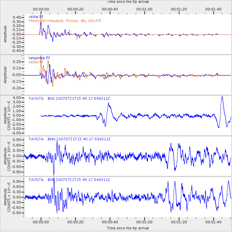
Signal To Noise
| Channel | StoN | STA | LTA |
| TA:F07A: :BHN:20070721T15:46:17.649011Z | 1.7625674 | 1.1348185E-7 | 6.43844E-8 |
| TA:F07A: :BHE:20070721T15:46:17.649011Z | 1.4568185 | 9.875203E-8 | 6.778609E-8 |
| TA:F07A: :BHZ:20070721T15:46:17.649011Z | 3.3351293 | 3.3116123E-7 | 9.9294866E-8 |
| Arrivals |
| Ps | 1.9 SECOND |
| PpPs | 5.2 SECOND |
| PsPs/PpSs | 7.0 SECOND |


