You are here: Home > Network List > TA - USArray Transportable Network (new EarthScope stations) Stations List
> Station L22K Petersville, AK, USA > Earthquake Result Viewer
L22K Petersville, AK, USA - Earthquake Result Viewer
| Earthquake location: |
Philippine Islands Region |
| Earthquake latitude/longitude: |
20.8/122.0 |
| Earthquake time(UTC): |
2019/07/26 (207) 23:37:58 GMT |
| Earthquake Depth: |
10 km |
| Earthquake Magnitude: |
5.9 Mww |
| Earthquake Catalog/Contributor: |
NEIC PDE/us |
|
| Network: |
TA USArray Transportable Network (new EarthScope stations) |
| Station: |
L22K Petersville, AK, USA |
| Lat/Lon: |
62.53 N/150.77 W |
| Elevation: |
817 m |
|
| Distance: |
70.5 deg |
| Az: |
29.435 deg |
| Baz: |
277.56 deg |
| Ray Param: |
0.05493925 |
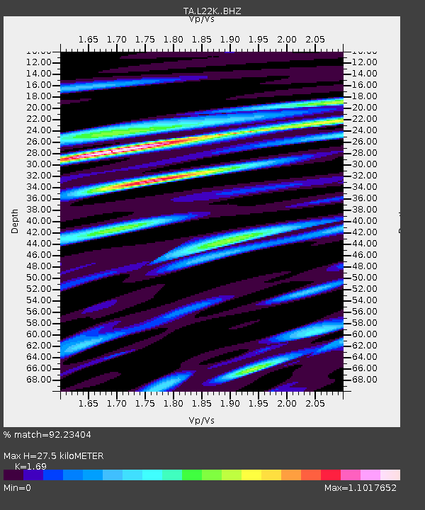
| Estimated Moho Depth: |
27.5 km |
| Estimated Crust Vp/Vs: |
1.69 |
| Assumed Crust Vp: |
6.438 km/s |
| Estimated Crust Vs: |
3.81 km/s |
| Estimated Crust Poisson's Ratio: |
0.23 |
|
| Radial Match: |
92.23404 % |
| Radial Bump: |
400 |
| Transverse Match: |
90.93072 % |
| Transverse Bump: |
400 |
| SOD ConfigId: |
19053131 |
| Insert Time: |
2019-08-09 23:43:51.085 +0000 |
| GWidth: |
2.5 |
| Max Bumps: |
400 |
| Tol: |
0.001 |
|

Signal To Noise
| Channel | StoN | STA | LTA |
| TA:L22K: :BHZ:20190726T23:48:42.049996Z | 6.227898 | 3.5279768E-7 | 5.6647952E-8 |
| TA:L22K: :BHN:20190726T23:48:42.049996Z | 2.4833863 | 1.6740482E-7 | 6.74099E-8 |
| TA:L22K: :BHE:20190726T23:48:42.049996Z | 2.0828974 | 1.595414E-7 | 7.6595896E-8 |
| Arrivals |
| Ps | 3.1 SECOND |
| PpPs | 11 SECOND |
| PsPs/PpSs | 14 SECOND |


