
Station TA L22K - Petersville, AK, USA
Network: TA - USArray Transportable Network (new EarthScope stations)
Nearby stations (2 deg radius)
| Station | Name | (Lat, Lon) | Start / End | Elevation |
| L22K | Petersville, AK, USA | (62.53, -150.77) | 2019-07-18 / 2599-12-31 | 817 m |
| Crust2 Type: | L2,thin continental arc, Mexico, 2 km seds. |
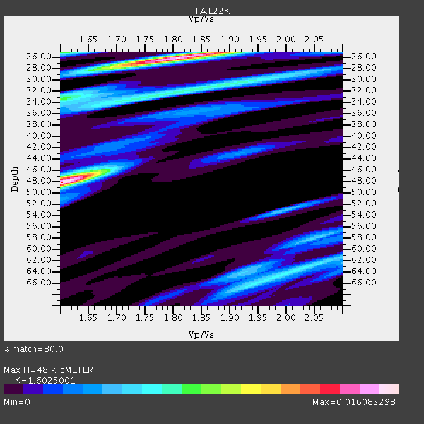
| Thickness Estimate: | 48 km |
| Thickness StdDev: | 11 km |
| Vp/Vs Estimate: | 1.60 |
| Vp/Vs StdDev: | 0.11 |
| Vs Estimate: | 4.018 km/s |
| Poisson's Ratio: | 0.18 |
| Peak Value: | 0.02 |
| Assumed Vp: | 6.438 km/s |
| Ps Weight: | 0.33333334 |
| PpPs Weight: | 0.33333334 |
| PsPs Weight: | 0.33333328 |
| Residual Complexity: | 0.851 |
| Nearby stations H: | 40 km +- 11 km |
| (2.0 deg) Vp/Vs: | 1.64 +- 0.05 |
5 with match > 90% ( 10.869565 %) and 13 with match > 80% ( 28.26087 %) out of 46.
Download stack as xyz text file.
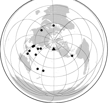
Azimuth Distribution of Events:
Prior Results for this Station
| Study | Thickness | Vp/Vs | Vp | Vs | Poissons Ratio | Extra |
| EARS | 48 km | 1.60 | 6.438 km/s | 4.018 km/s | 0.18 | |
| Crust2.0 | 34 km | 1.78 | 6.438 km/s | 3.624 km/s | 0.27 | L2,thin continental arc, Mexico, 2 km seds. |
| Global Maxima | 48 km | 1.60 | 6.438 km/s | 4.018 km/s | 0.18 | amp=0.016083298 |
| Local Maxima 1 | 26 km | 1.81 | 6.438 km/s | 3.557 km/s | 0.28 | amp=0.0153557435 |
| Local Maxima 2 | 25 km | 1.60 | 6.438 km/s | 4.018 km/s | 0.18 | amp=0.0075356364 |
| Local Maxima 3 | 32 km | 1.79 | 6.438 km/s | 3.592 km/s | 0.27 | amp=0.0065744636 |
| Local Maxima 4 | 64 km | 2.01 | 6.438 km/s | 3.203 km/s | 0.34 | amp=0.0059556034 |
| Predicted Arrivals for vertical incidence (zero ray parameter) | |
| Ps | 4.49 SECOND |
| PpPs | 19.40 SECOND |
| PsPs/PpSs | 23.89 SECOND |
Events Processed for this Station
Download zip of receiver functions as SAC
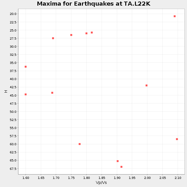
Plot maxima for each earthquake.
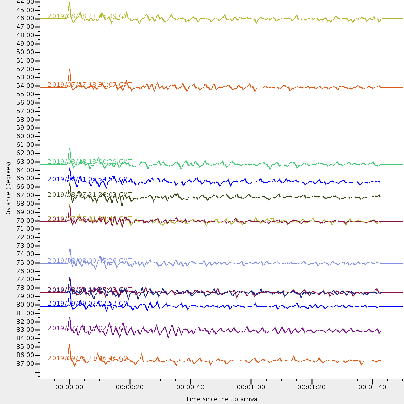
Events Used in the Stack
(13 events)| Radial Match | Distance | Baz | FERegion | Time | Lat/Lon | Depth | Magnitude |
| 94.66446 | 81.6 deg | 266.138 deg | Mindanao, Philippines | 2019/09/29 02:02:52 GMT | (5.7, 126.5) | 76 km | 6.2 Mww |
| 92.84348 | 79.9 deg | 359.625 deg | Turkey | 2019/08/08 11:25:31 GMT | (37.9, 29.7) | 10 km | 5.8 Mww |
| 92.23404 | 70.5 deg | 277.56 deg | Philippine Islands Region | 2019/07/26 23:37:58 GMT | (20.8, 122.0) | 10 km | 5.9 Mww |
| 92.09274 | 76.0 deg | 327.142 deg | Hindu Kush Region, Afghanistan | 2019/08/08 00:45:26 GMT | (36.5, 70.0) | 222 km | 5.8 Mww |
| 90.69114 | 52.9 deg | 271.547 deg | Near S. Coast Of Honshu, Japan | 2019/07/27 18:31:07 GMT | (33.1, 137.3) | 367 km | 6.3 Mww |
| 89.67419 | 70.5 deg | 277.493 deg | Philippine Islands Region | 2019/07/27 01:24:44 GMT | (20.8, 122.0) | 10 km | 5.7 Mww |
| 87.60036 | 84.8 deg | 219.539 deg | Vanuatu Islands | 2019/07/31 15:02:33 GMT | (-16.2, 167.9) | 179 km | 6.6 mww |
| 84.59299 | 88.8 deg | 260.318 deg | Seram, Indonesia | 2019/09/25 23:46:46 GMT | (-3.4, 128.4) | 30 km | 6.5 Mww |
| 84.018074 | 67.4 deg | 279.53 deg | Taiwan | 2019/08/07 21:28:02 GMT | (24.5, 121.9) | 10 km | 5.9 Mww |
| 83.93868 | 63.0 deg | 253.243 deg | Mariana Islands | 2019/08/18 18:00:29 GMT | (16.6, 146.4) | 34 km | 5.9 Mi |
| 81.85991 | 79.8 deg | 206.031 deg | Fiji Islands Region | 2019/08/22 19:27:12 GMT | (-14.8, -177.3) | 10 km | 5.8 Mww |
| 81.06508 | 43.9 deg | 272.786 deg | Hokkaido, Japan Region | 2019/08/28 23:46:39 GMT | (41.1, 143.0) | 17 km | 6.1 Mww |
| 80.851395 | 65.3 deg | 109.733 deg | El Salvador | 2019/07/31 05:54:55 GMT | (13.3, -89.3) | 72 km | 5.9 Mww |
Losers
(33 events)| Radial Match | Distance | Baz | FERegion | Time | Lat/Lon | Depth | Magnitude | Reason |
| 88.426674 | 85.5 deg | 205.872 deg | Fiji Islands Region | 2019/09/01 15:54:20 GMT | (-20.4, -178.4) | 617 km | 6.5 Mi | |
| 78.098404 | 83.3 deg | 220.822 deg | Vanuatu Islands | 2019/08/24 15:51:27 GMT | (-14.3, 167.2) | 115 km | 6.0 Mww | |
| 77.88089 | 51.7 deg | 268.477 deg | Southeast Of Honshu, Japan | 2019/07/29 20:37:42 GMT | (32.8, 140.6) | 53 km | 5.7 Mww | |
| 77.63919 | 83.8 deg | 202.826 deg | Tonga Islands | 2019/08/05 09:01:08 GMT | (-19.4, -174.9) | 10 km | 5.7 mb | |
| 77.02581 | 70.6 deg | 277.654 deg | Philippine Islands Region | 2019/07/26 20:16:57 GMT | (20.8, 121.9) | 9.1 km | 5.4 Mww | |
| 76.6602 | 80.8 deg | 222.582 deg | Santa Cruz Islands | 2019/08/20 13:03:52 GMT | (-11.4, 166.3) | 37 km | 6.0 Mww | |
| 74.991325 | 86.4 deg | 218.357 deg | Vanuatu Islands | 2019/08/06 22:14:14 GMT | (-18.0, 168.6) | 150 km | 5.9 Mww | |
| 74.610886 | 80.7 deg | 266.683 deg | Mindanao, Philippines | 2019/09/10 05:39:24 GMT | (6.7, 126.5) | 56 km | 5.6 Mww | |
| 74.08956 | 76.9 deg | 305.388 deg | Eastern Xizang-India Border Reg. | 2019/07/19 09:22:15 GMT | (27.7, 92.8) | 17 km | 5.5 Mww | |
| 72.26771 | 80.3 deg | 300.961 deg | Myanmar | 2019/08/31 15:09:22 GMT | (22.7, 95.5) | 10 km | 5.5 Mww | |
| 71.26386 | 79.1 deg | 88.365 deg | Near Coast Of Venezuela | 2019/09/09 18:05:17 GMT | (10.5, -64.4) | 10 km | 5.5 Mww | |
| 71.11545 | 61.0 deg | 112.607 deg | Near Coast Of Chiapas, Mexico | 2019/08/12 20:39:35 GMT | (16.0, -93.7) | 92 km | 5.5 Mww | |
| 70.90856 | 50.7 deg | 126.537 deg | Revilla Gigedo Islands Region | 2019/08/14 21:35:19 GMT | (20.5, -109.2) | 10 km | 5.8 Mww | |
| 69.71455 | 47.2 deg | 271.253 deg | Near East Coast Of Honshu, Japan | 2019/08/04 10:23:03 GMT | (37.7, 141.5) | 39 km | 6.3 Mww | |
| 69.01949 | 86.6 deg | 261.287 deg | Halmahera, Indonesia | 2019/09/14 16:21:29 GMT | (-1.0, 128.5) | 10 km | 5.9 Mww | |
| 68.38216 | 62.5 deg | 254.67 deg | Mariana Islands | 2019/08/22 11:02:40 GMT | (17.6, 145.5) | 512 km | 5.4 Mww | |
| 68.07208 | 84.7 deg | 264.534 deg | Northern Molucca Sea | 2019/08/06 03:51:16 GMT | (2.2, 126.5) | 32 km | 5.2 Mww | |
| 67.9966 | 60.3 deg | 273.834 deg | Ryukyu Islands, Japan | 2019/08/20 12:52:22 GMT | (28.0, 130.9) | 10 km | 5.2 Mww | |
| 67.985016 | 78.2 deg | 323.032 deg | Pakistan | 2019/09/24 11:01:55 GMT | (33.1, 73.8) | 10 km | 5.8 mb | |
| 65.96433 | 65.6 deg | 277.891 deg | Northeast Of Taiwan | 2019/07/22 20:46:58 GMT | (25.3, 124.4) | 100 km | 5.1 Mww | |
| 65.73312 | 78.5 deg | 279.574 deg | South China Sea | 2019/09/05 13:58:34 GMT | (14.7, 116.2) | 13 km | 5.3 Mww | |
| 64.84254 | 81.6 deg | 266.843 deg | Mindanao, Philippines | 2019/08/02 16:10:11 GMT | (6.0, 125.9) | 148 km | 5.5 mb | |
| 64.66391 | 44.9 deg | 274.069 deg | Near East Coast Of Honshu, Japan | 2019/08/15 05:32:53 GMT | (40.8, 141.2) | 86 km | 5.4 Mww | |
| 61.299183 | 84.3 deg | 219.962 deg | Vanuatu Islands | 2019/08/07 05:32:40 GMT | (-15.5, 167.7) | 123 km | 5.8 Mww | |
| 60.93491 | 67.7 deg | 252.99 deg | South Of Mariana Islands | 2019/07/21 17:35:38 GMT | (12.3, 144.4) | 48 km | 5.5 mb | |
| 60.72015 | 67.6 deg | 253.039 deg | South Of Mariana Islands | 2019/07/21 17:25:14 GMT | (12.3, 144.4) | 10 km | 5.5 Mww | |
| 60.524994 | 90.6 deg | 257.086 deg | Banda Sea | 2019/09/21 19:53:10 GMT | (-6.5, 130.4) | 48 km | 5.9 Mww | |
| 60.401596 | 87.6 deg | 258.001 deg | Irian Jaya Region, Indonesia | 2019/07/22 10:06:56 GMT | (-3.4, 131.0) | 10 km | 5.5 Mww | |
| 57.52875 | 81.7 deg | 221.489 deg | Santa Cruz Islands | 2019/08/22 22:54:26 GMT | (-12.6, 167.0) | 213 km | 5.6 Mww | |
| 56.256996 | 84.8 deg | 203.363 deg | Tonga Islands | 2019/08/24 21:21:27 GMT | (-20.2, -175.6) | 215 km | 5.5 Mww | |
| 49.621647 | 82.3 deg | 200.417 deg | Tonga Islands Region | 2019/09/20 05:28:25 GMT | (-18.3, -172.1) | 10 km | 5.1 Mww | |
| 44.972267 | 94.9 deg | 203.296 deg | Kermadec Islands, New Zealand | 2019/09/27 12:05:02 GMT | (-30.1, -177.8) | 35 km | 6.0 Mww | |
| 44.128883 | 83.0 deg | 265.228 deg | Talaud Islands, Indonesia | 2019/09/10 23:32:23 GMT | (4.0, 126.7) | 24 km | 5.6 Mww |

