You are here: Home > Network List > TA - USArray Transportable Network (new EarthScope stations) Stations List
> Station L22K Petersville, AK, USA > Earthquake Result Viewer
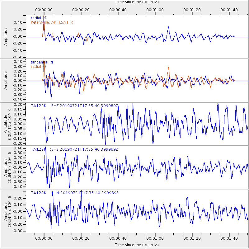
L22K Petersville, AK, USA - Earthquake Result Viewer
*The percent match for this event was below the threshold and hence no stack was calculated.
| Earthquake location: |
South Of Mariana Islands |
| Earthquake latitude/longitude: |
12.3/144.4 |
| Earthquake time(UTC): |
2019/07/21 (202) 17:25:14 GMT |
| Earthquake Depth: |
10 km |
| Earthquake Magnitude: |
5.5 Mww |
| Earthquake Catalog/Contributor: |
NEIC PDE/us |
|
| Network: |
TA USArray Transportable Network (new EarthScope stations) |
| Station: |
L22K Petersville, AK, USA |
| Lat/Lon: |
62.53 N/150.77 W |
| Elevation: |
817 m |
|
| Distance: |
67.6 deg |
| Az: |
26.999 deg |
| Baz: |
253.039 deg |
| Ray Param: |
$rayparam |
*The percent match for this event was below the threshold and hence was not used in the summary stack. |
|
| Radial Match: |
60.72015 % |
| Radial Bump: |
400 |
| Transverse Match: |
69.12006 % |
| Transverse Bump: |
400 |
| SOD ConfigId: |
19053131 |
| Insert Time: |
2019-08-10 18:07:40.545 +0000 |
| GWidth: |
2.5 |
| Max Bumps: |
400 |
| Tol: |
0.001 |
|
Signal To Noise
| Channel | StoN | STA | LTA |
| TA:L22K: :BHZ:20190721T17:35:40.399989Z | 4.05014 | 2.2311147E-7 | 5.508735E-8 |
| TA:L22K: :BHN:20190721T17:35:40.399989Z | 2.2005515 | 1.1194089E-7 | 5.086947E-8 |
| TA:L22K: :BHE:20190721T17:35:40.399989Z | 1.6590447 | 9.715444E-8 | 5.856047E-8 |
| Arrivals |
| Ps | |
| PpPs | |
| PsPs/PpSs | |


