You are here: Home > Network List > TA - USArray Transportable Network (new EarthScope stations) Stations List
> Station X13A Yucca, AZ, USA > Earthquake Result Viewer
X13A Yucca, AZ, USA - Earthquake Result Viewer
| Earthquake location: |
Near Coast Of Peru |
| Earthquake latitude/longitude: |
-13.6/-76.6 |
| Earthquake time(UTC): |
2007/08/19 (231) 01:22:40 GMT |
| Earthquake Depth: |
26 km |
| Earthquake Magnitude: |
5.9 MB, 5.4 MS, 5.8 MW, 5.5 ML |
| Earthquake Catalog/Contributor: |
WHDF/NEIC |
|
| Network: |
TA USArray Transportable Network (new EarthScope stations) |
| Station: |
X13A Yucca, AZ, USA |
| Lat/Lon: |
34.59 N/113.83 W |
| Elevation: |
889 m |
|
| Distance: |
59.6 deg |
| Az: |
324.646 deg |
| Baz: |
137.008 deg |
| Ray Param: |
0.06205895 |
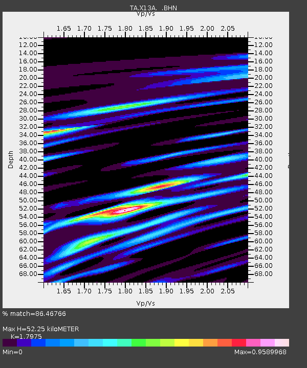
| Estimated Moho Depth: |
52.25 km |
| Estimated Crust Vp/Vs: |
1.80 |
| Assumed Crust Vp: |
6.276 km/s |
| Estimated Crust Vs: |
3.491 km/s |
| Estimated Crust Poisson's Ratio: |
0.28 |
|
| Radial Match: |
86.46766 % |
| Radial Bump: |
400 |
| Transverse Match: |
81.18837 % |
| Transverse Bump: |
400 |
| SOD ConfigId: |
2564 |
| Insert Time: |
2010-03-07 02:18:46.567 +0000 |
| GWidth: |
2.5 |
| Max Bumps: |
400 |
| Tol: |
0.001 |
|

Signal To Noise
| Channel | StoN | STA | LTA |
| TA:X13A: :BHN:20070819T01:32:11.024014Z | 2.551896 | 1.6855297E-7 | 6.605009E-8 |
| TA:X13A: :BHE:20070819T01:32:11.024014Z | 2.2813256 | 1.3525765E-7 | 5.928906E-8 |
| TA:X13A: :BHZ:20070819T01:32:11.024014Z | 5.29953 | 3.4463739E-7 | 6.5031685E-8 |
| Arrivals |
| Ps | 6.9 SECOND |
| PpPs | 22 SECOND |
| PsPs/PpSs | 29 SECOND |


