
Station TA X13A - Yucca, AZ, USA
Network: TA - USArray Transportable Network (new EarthScope stations)
Nearby stations (2 deg radius)
| Station | Name | (Lat, Lon) | Start / End | Elevation |
| X13A | Yucca, AZ, USA | (34.59, -113.83) | 2006-03-14 / 2499-01-01 | 0.9 km |
| Crust2 Type: | M5,extended crust, 0.5 km seds. |
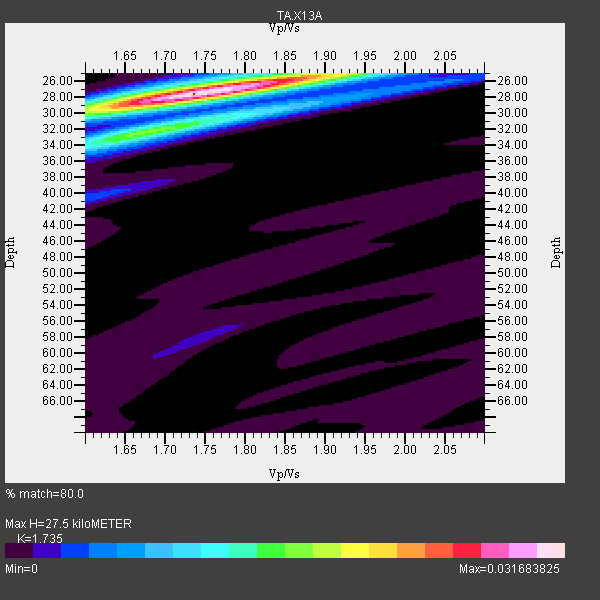
| Thickness Estimate: | 28 km |
| Thickness StdDev: | 0.3 km |
| Vp/Vs Estimate: | 1.74 |
| Vp/Vs StdDev: | 0.02 |
| Vs Estimate: | 3.617 km/s |
| Poisson's Ratio: | 0.25 |
| Peak Value: | 0.03 |
| Assumed Vp: | 6.276 km/s |
| Ps Weight: | 0.33333334 |
| PpPs Weight: | 0.33333334 |
| PsPs Weight: | 0.33333328 |
| Residual Complexity: | 0.431 |
| Nearby stations H: | +- |
| (2.0 deg) Vp/Vs: | +- |
38 with match > 90% ( 58.46154 %) and 65 with match > 80% ( 100.0 %) out of 65.
Download stack as xyz text file.
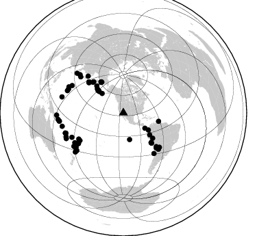
Azimuth Distribution of Events:
Prior Results for this Station
| Study | Thickness | Vp/Vs | Vp | Vs | Poissons Ratio | Extra |
| EARS | 28 km | 1.74 | 6.276 km/s | 3.617 km/s | 0.25 | |
| Crust2.0 | 31 km | 1.78 | 6.276 km/s | 3.529 km/s | 0.27 | M5,extended crust, 0.5 km seds. |
| Global Maxima | 28 km | 1.74 | 6.276 km/s | 3.617 km/s | 0.25 | amp=0.031683825 |
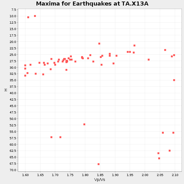
| Local Maxima 1 | 32 km | 1.70 | 6.276 km/s | 3.697 km/s | 0.23 | amp=0.01372461 |
| Local Maxima 2 | 25 km | 1.88 | 6.276 km/s | 3.329 km/s | 0.30 | amp=0.011666025 |
| Local Maxima 3 | 30 km | 1.85 | 6.276 km/s | 3.402 km/s | 0.29 | amp=0.006278898 |
| Local Maxima 4 | 30 km | 1.61 | 6.276 km/s | 3.898 km/s | 0.19 | amp=0.0053677284 |
| Predicted Arrivals for vertical incidence (zero ray parameter) | |
| Ps | 3.22 SECOND |
| PpPs | 11.98 SECOND |
| PsPs/PpSs | 15.21 SECOND |
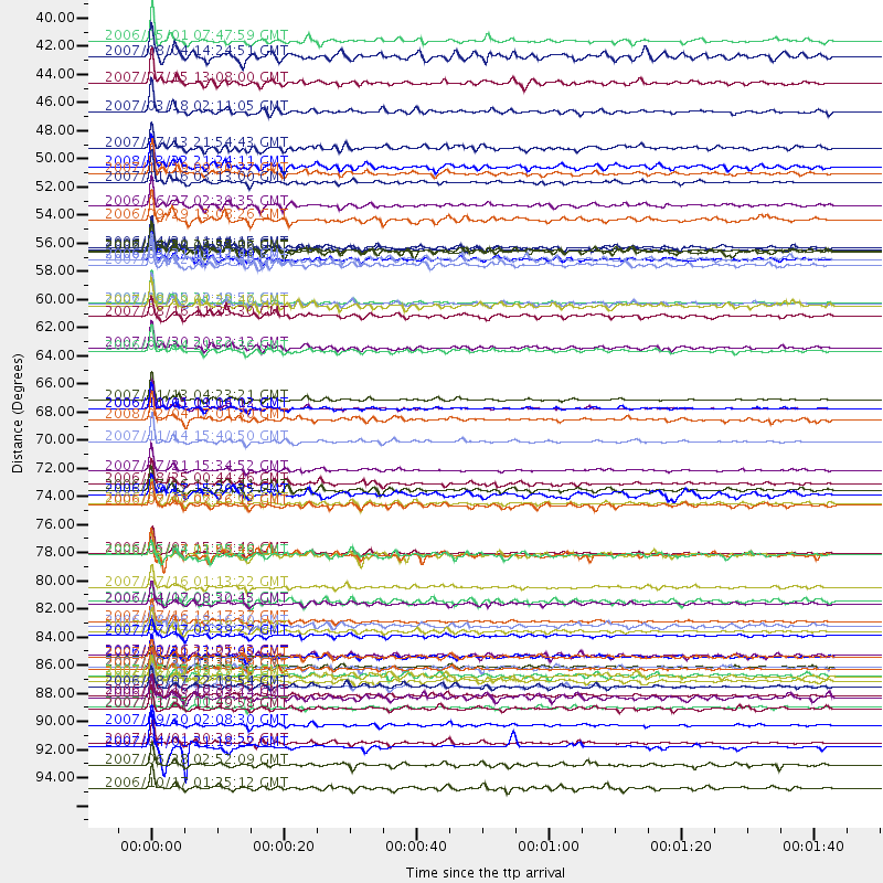
Events Processed for this Station
Download zip of receiver functions as SAC
Plot maxima for each earthquake.
Events Used in the Stack
(65 events)| Radial Match | Distance | Baz | FERegion | Time | Lat/Lon | Depth | Magnitude |
| 99.311226 | 67.6 deg | 311.863 deg | Kuril Islands | 2006/11/15 11:14:13 GMT | (46.6, 153.3) | 10 km | 6.5 MB, 7.8 MS, 8.3 MW, 7.9 MW |
| 98.70766 | 79.0 deg | 236.204 deg | Tonga Islands | 2006/05/03 15:26:40 GMT | (-20.2, -174.1) | 55 km | 7.2 MB, 7.8 MS, 7.9 MW, 7.9 MW |
| 98.29715 | 59.4 deg | 136.835 deg | Near Coast Of Peru | 2007/08/15 23:40:57 GMT | (-13.4, -76.6) | 39 km | 6.7 MB, 7.9 MS, 8.0 MW, 7.5 ME |
| 97.96791 | 70.3 deg | 136.924 deg | Northern Chile | 2007/11/14 15:40:50 GMT | (-22.2, -69.9) | 40 km | 6.7 MB, 7.4 MS, 7.7 MW, 7.4 ME |
| 97.57482 | 85.3 deg | 234.046 deg | South Of Fiji Islands | 2007/12/09 07:28:20 GMT | (-26.0, -177.5) | 152 km | 7.0 MB, 7.8 MW, 7.7 MW |
| 97.44469 | 55.3 deg | 324.334 deg | Eastern Siberia, Russia | 2006/04/20 23:25:02 GMT | (60.9, 167.1) | 22 km | 6.8 MB, 7.6 MS, 7.6 MW, 7.3 MW |
| 97.22167 | 88.2 deg | 295.476 deg | Volcano Islands, Japan Region | 2007/09/28 13:38:59 GMT | (22.0, 142.7) | 276 km | 6.7 MB, 7.4 MW, 7.4 MW |
| 97.13528 | 94.0 deg | 262.564 deg | Solomon Islands | 2007/04/01 20:39:56 GMT | (-8.5, 157.0) | 10 km | 6.8 MB, 7.9 MS, 8.1 MW, 7.7 ME |
| 96.399605 | 62.9 deg | 316.21 deg | Kamchatka Peninsula, Russia | 2007/05/30 20:22:12 GMT | (52.1, 157.3) | 116 km | 6.4 MB, 6.4 MW, 6.4 MW |
| 96.36211 | 81.8 deg | 310.083 deg | Near West Coast Of Honshu, Japan | 2007/07/16 01:13:22 GMT | (37.5, 138.4) | 12 km | 6.5 MB, 6.4 MS, 6.6 MW, 6.5 MW |
| 96.19292 | 89.6 deg | 250.786 deg | Vanuatu Islands | 2007/08/01 17:08:51 GMT | (-15.6, 167.7) | 120 km | 6.2 MB, 7.2 MW, 7.2 MW |
| 96.13211 | 90.3 deg | 230.794 deg | Kermadec Islands Region | 2006/05/16 10:39:23 GMT | (-31.8, -179.3) | 152 km | 6.8 MB, 7.4 MW, 7.4 MW |
| 96.096275 | 67.0 deg | 311.101 deg | East Of Kuril Islands | 2007/01/13 04:23:21 GMT | (46.2, 154.5) | 10 km | 7.3 MB, 8.2 MS, 8.1 MW, 7.9 MW |
| 95.923584 | 49.9 deg | 129.842 deg | Peru-Ecuador Border Region | 2007/11/16 03:13:00 GMT | (-2.3, -77.8) | 123 km | 6.3 MB, 6.8 MW, 6.7 MW |
| 95.48861 | 75.1 deg | 237.476 deg | Samoa Islands Region | 2006/09/28 06:22:09 GMT | (-16.6, -172.0) | 28 km | 6.5 MB, 6.6 MS, 6.9 MW, 6.7 MW |
| 95.32598 | 95.7 deg | 264.314 deg | Solomon Islands | 2007/06/28 02:52:09 GMT | (-8.0, 154.6) | 10 km | 6.3 MB, 6.7 MS, 6.7 MW, 6.7 MW |
| 94.7867 | 59.4 deg | 136.95 deg | Near Coast Of Peru | 2006/10/20 10:48:56 GMT | (-13.5, -76.7) | 23 km | 5.9 MB, 6.6 MS, 6.7 MW, 6.6 MW |
| 94.679825 | 49.2 deg | 311.01 deg | Andreanof Islands, Aleutian Is. | 2007/12/19 09:30:27 GMT | (51.4, -179.5) | 29 km | 6.4 MB, 7.1 MS, 7.1 MW, 7.0 MW |
| 94.45779 | 88.0 deg | 291.477 deg | Mariana Islands | 2007/10/31 03:30:17 GMT | (18.9, 145.4) | 223 km | 6.2 MB, 7.2 MW, 7.2 MW |
| 94.414375 | 84.5 deg | 311.31 deg | Sea Of Japan | 2007/07/16 14:17:37 GMT | (36.8, 134.9) | 350 km | 6.2 MB, 6.8 MW, 6.8 MW |
| 94.01489 | 42.1 deg | 312.242 deg | Fox Islands, Aleutian Islands | 2007/07/15 13:08:00 GMT | (52.5, -168.0) | 10 km | 5.8 MB, 5.9 MS, 6.1 MW, 6.0 MW |
| 93.69363 | 72.6 deg | 133.725 deg | Jujuy Province, Argentina | 2007/07/21 15:34:52 GMT | (-22.2, -65.8) | 290 km | 5.8 MB, 6.4 MW, 6.3 MW |
| 93.64362 | 94.3 deg | 262.684 deg | Solomon Islands | 2007/04/01 21:18:22 GMT | (-8.5, 156.7) | 10 km | 5.8 MB |
| 93.617386 | 55.2 deg | 323.74 deg | Eastern Siberia, Russia | 2006/04/29 16:58:06 GMT | (60.5, 167.5) | 11 km | 6.4 MB, 6.6 MS, 6.6 MW, 6.4 MW |
| 93.32136 | 63.2 deg | 315.121 deg | Near East Coast Of Kamchatka | 2006/08/24 21:50:36 GMT | (51.1, 157.5) | 43 km | 5.9 MB, 6.2 MS, 6.5 MW, 6.5 MW |
| 93.18484 | 68.5 deg | 135.689 deg | Near Coast Of Northern Chile | 2008/02/04 17:01:30 GMT | (-20.2, -70.0) | 44 km | 6.0 MB, 6.2 MS, 6.3 MW, 6.3 MW |
| 92.91053 | 91.2 deg | 245.817 deg | Vanuatu Islands | 2007/03/25 00:40:01 GMT | (-20.6, 169.4) | 34 km | 6.5 MB, 7.0 MS, 7.1 MW, 7.1 MW |
| 92.24443 | 44.3 deg | 124.362 deg | South Of Panama | 2007/03/18 02:11:05 GMT | (4.6, -78.5) | 8.0 km | 6.4 MB, 5.7 MS, 6.2 MW, 6.1 MW |
| 92.06816 | 67.7 deg | 311.754 deg | Kuril Islands | 2006/10/01 09:06:02 GMT | (46.5, 153.2) | 19 km | 6.1 MB, 6.4 MS, 6.6 MW, 6.5 MW |
| 91.82761 | 85.5 deg | 234.029 deg | South Of Fiji Islands | 2007/07/17 09:39:27 GMT | (-26.2, -177.7) | 10 km | 5.7 MB, 6.0 MS, 6.1 MW, 6.0 MW |
| 91.681625 | 92.6 deg | 284.467 deg | South Of Mariana Islands | 2007/09/30 02:08:30 GMT | (10.5, 145.7) | 14 km | 6.4 MB, 7.1 MS, 6.9 MW, 6.9 MW |
| 91.64076 | 88.7 deg | 250.435 deg | Vanuatu Islands | 2007/07/15 09:27:34 GMT | (-15.4, 168.6) | 8.0 km | 6.0 MB, 5.8 MS, 6.1 MW, 6.0 MW |
| 91.581985 | 38.7 deg | 125.523 deg | Panama-Costa Rica Border Region | 2006/05/01 07:47:59 GMT | (8.2, -82.9) | 13 km | 5.1 MB, 5.6 MS, 5.9 MW, 5.9 MW |
| 91.03279 | 97.6 deg | 268.085 deg | New Britain Region, P.N.G. | 2006/10/17 01:25:12 GMT | (-5.9, 151.0) | 32 km | 6.4 MB, 6.9 MS, 6.7 MW, 6.6 MW |
| 90.778625 | 87.2 deg | 230.968 deg | Kermadec Islands Region | 2006/03/31 13:21:00 GMT | (-29.6, -176.8) | 17 km | 5.9 MB, 6.7 MS, 6.5 MW, 6.5 MW |
| 90.68247 | 89.6 deg | 250.573 deg | Vanuatu Islands | 2006/08/07 22:18:54 GMT | (-15.8, 167.8) | 141 km | 6.0 MB, 6.8 MW, 6.8 MW |
| 90.64164 | 55.0 deg | 324.781 deg | Eastern Siberia, Russia | 2006/04/21 11:14:15 GMT | (61.4, 167.5) | 12 km | 5.8 MB, 5.8 MS, 6.1 MW, 6.1 MW |
| 90.06681 | 73.6 deg | 136.143 deg | Chile-Argentina Border Region | 2006/08/25 00:44:46 GMT | (-24.4, -67.0) | 184 km | 5.9 MB, 6.6 MW, 6.6 MW |
| 89.70908 | 48.6 deg | 312.013 deg | Andreanof Islands, Aleutian Is. | 2008/03/22 21:24:11 GMT | (52.2, -178.7) | 132 km | 5.8 MB, 6.2 MW, 6.1 MW |
| 89.643105 | 88.1 deg | 231.535 deg | Kermadec Islands, New Zealand | 2007/01/31 03:15:52 GMT | (-29.8, -178.0) | 34 km | 6.1 MB, 6.3 MS, 6.5 MW, 6.4 MW |
| 89.55681 | 56.0 deg | 324.265 deg | Eastern Siberia, Russia | 2006/05/22 11:12:00 GMT | (60.8, 165.7) | 16 km | 6.0 MB, 6.7 MS, 6.6 MW, 6.5 MW |
| 88.9418 | 83.0 deg | 244.587 deg | Fiji Islands Region | 2006/04/07 08:30:45 GMT | (-16.5, 177.0) | 22 km | 5.9 MB, 6.4 MS, 6.4 MW, 6.4 MW |
| 88.70044 | 75.3 deg | 239.56 deg | Tonga Islands | 2006/07/07 07:26:12 GMT | (-15.2, -173.6) | 35 km | 5.7 MB, 5.9 MS, 6.0 MW, 6.0 MW |
| 88.65631 | 87.1 deg | 235.975 deg | South Of Fiji Islands | 2007/10/16 21:05:43 GMT | (-25.8, 179.5) | 509 km | 6.2 MB, 6.6 MW, 6.5 MW |
| 86.47064 | 40.0 deg | 166.865 deg | Central East Pacific Rise | 2007/08/04 14:24:51 GMT | (-4.8, -105.4) | 10 km | 5.7 MS, 5.4 MB, 6.0 MW, 5.9 MW |
| 86.46766 | 59.6 deg | 137.008 deg | Near Coast Of Peru | 2007/08/19 01:22:40 GMT | (-13.6, -76.6) | 26 km | 5.9 MB, 5.4 MS, 5.8 MW, 5.5 ML |
| 86.42854 | 79.2 deg | 235.759 deg | Tonga Islands | 2006/05/17 03:06:16 GMT | (-20.6, -173.9) | 10 km | 5.8 MB, 5.8 MS, 6.0 MW, 5.8 MW |
| 85.998245 | 56.0 deg | 323.967 deg | Eastern Siberia, Russia | 2006/04/21 04:32:43 GMT | (60.5, 165.8) | 9.0 km | 6.3 MB, 5.6 MS, 6.1 MW, 6.1 ME |
| 85.446045 | 51.7 deg | 312.573 deg | Rat Islands, Aleutian Islands | 2006/06/27 02:39:35 GMT | (52.2, 176.2) | 34 km | 5.6 MB, 6.0 MS, 6.2 MW, 6.2 MW |
| 85.39389 | 91.3 deg | 257.669 deg | Solomon Islands | 2007/11/27 11:49:58 GMT | (-10.9, 162.1) | 16 km | 5.9 MB, 6.7 MS, 6.6 MW, 6.4 MW |
| 85.23807 | 89.2 deg | 310.501 deg | Kyushu, Japan | 2006/06/11 20:01:26 GMT | (33.1, 131.1) | 140 km | 5.9 MB, 6.3 MW, 6.3 MW |
| 85.20373 | 74.1 deg | 142.936 deg | Off Coast Of Central Chile | 2006/07/16 11:42:41 GMT | (-28.7, -72.5) | 10 km | 5.9 MB, 5.7 MS, 6.2 MW, 6.2 MW |
| 83.71021 | 88.8 deg | 230.997 deg | Kermadec Islands, New Zealand | 2007/05/17 19:29:10 GMT | (-30.7, -178.2) | 41 km | 5.5 MB, 5.6 MS, 6.0 MW, 5.9 MW |
| 83.48674 | 79.2 deg | 235.858 deg | Tonga Islands | 2006/05/04 11:25:26 GMT | (-20.6, -174.0) | 11 km | 5.7 MB, 5.8 MS, 6.0 MW, 5.8 MW |
| 83.30535 | 55.3 deg | 315.254 deg | Komandorskiye Ostrova Region | 2007/07/29 04:54:36 GMT | (53.6, 169.7) | 26 km | 6.0 MB, 5.5 MS, 5.9 MW, 5.8 MW |
| 82.920746 | 52.8 deg | 103.538 deg | Trinidad | 2006/09/29 13:08:26 GMT | (10.9, -61.8) | 53 km | 5.9 MB, 5.4 MS, 6.1 MW, 6.0 MW |
| 82.86303 | 47.2 deg | 311.389 deg | Andreanof Islands, Aleutian Is. | 2007/07/13 21:54:43 GMT | (51.8, -176.3) | 35 km | 5.7 MB, 5.6 MS, 6.0 MW, 5.9 MW |
| 82.64325 | 79.2 deg | 235.788 deg | Tonga Islands | 2006/05/17 21:57:49 GMT | (-20.6, -174.0) | 10 km | 5.3 MB, 5.4 MS, 5.8 MW, 5.5 MW |
| 82.54518 | 87.3 deg | 293.53 deg | Mariana Islands | 2007/01/30 21:37:45 GMT | (21.0, 144.7) | 30 km | 6.3 MB, 6.5 MS, 6.6 MW, 6.5 MW |
| 81.71177 | 56.4 deg | 130.909 deg | Peru-Brazil Border Region | 2007/07/12 05:23:49 GMT | (-7.9, -74.4) | 152 km | 5.9 MB, 6.1 MW, 6.0 MW |
| 80.98868 | 84.8 deg | 298.05 deg | Bonin Islands, Japan Region | 2006/08/06 18:16:40 GMT | (26.1, 144.0) | 23 km | 6.0 MB, 5.6 MS, 5.8 MW, 5.8 MW |
| 80.96022 | 74.4 deg | 316.011 deg | Sakhalin, Russia | 2006/08/17 15:20:35 GMT | (46.5, 141.9) | 17 km | 6.0 MB, 5.2 MS, 5.6 MW, 5.5 MW |
| 80.8977 | 82.9 deg | 238.403 deg | Fiji Islands Region | 2007/11/19 00:52:12 GMT | (-21.2, -178.8) | 558 km | 6.2 MB, 6.3 MW, 6.3 MW |
| 80.87751 | 60.4 deg | 137.044 deg | Near Coast Of Peru | 2007/08/16 11:35:30 GMT | (-14.3, -76.1) | 35 km | 5.7 MB, 5.5 MS, 6.0 MW, 5.6 ML |
| 80.61646 | 90.5 deg | 247.413 deg | Vanuatu Islands | 2006/10/03 18:03:14 GMT | (-18.9, 169.0) | 171 km | 5.9 MB, 6.3 MW, 6.3 MW |
Losers
(0 events)| Radial Match | Distance | Baz | FERegion | Time | Lat/Lon | Depth | Magnitude | Reason |
