You are here: Home > Network List > TA - USArray Transportable Network (new EarthScope stations) Stations List
> Station X13A Yucca, AZ, USA > Earthquake Result Viewer
X13A Yucca, AZ, USA - Earthquake Result Viewer
| Earthquake location: |
Komandorskiye Ostrova Region |
| Earthquake latitude/longitude: |
53.6/169.7 |
| Earthquake time(UTC): |
2007/07/29 (210) 04:54:36 GMT |
| Earthquake Depth: |
26 km |
| Earthquake Magnitude: |
6.0 MB, 5.5 MS, 5.9 MW, 5.8 MW |
| Earthquake Catalog/Contributor: |
WHDF/NEIC |
|
| Network: |
TA USArray Transportable Network (new EarthScope stations) |
| Station: |
X13A Yucca, AZ, USA |
| Lat/Lon: |
34.59 N/113.83 W |
| Elevation: |
889 m |
|
| Distance: |
55.3 deg |
| Az: |
77.254 deg |
| Baz: |
315.254 deg |
| Ray Param: |
0.064830884 |
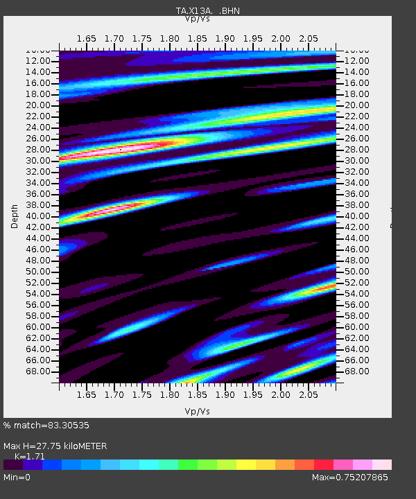
| Estimated Moho Depth: |
27.75 km |
| Estimated Crust Vp/Vs: |
1.71 |
| Assumed Crust Vp: |
6.276 km/s |
| Estimated Crust Vs: |
3.67 km/s |
| Estimated Crust Poisson's Ratio: |
0.24 |
|
| Radial Match: |
83.30535 % |
| Radial Bump: |
400 |
| Transverse Match: |
74.675804 % |
| Transverse Bump: |
400 |
| SOD ConfigId: |
2564 |
| Insert Time: |
2010-03-07 02:18:59.381 +0000 |
| GWidth: |
2.5 |
| Max Bumps: |
400 |
| Tol: |
0.001 |
|

Signal To Noise
| Channel | StoN | STA | LTA |
| TA:X13A: :BHN:20070729T05:03:37.225015Z | 0.85713995 | 5.281233E-8 | 6.161459E-8 |
| TA:X13A: :BHE:20070729T05:03:37.225015Z | 1.5263386 | 9.629243E-8 | 6.308721E-8 |
| TA:X13A: :BHZ:20070729T05:03:37.225015Z | 6.2736945 | 2.0405061E-7 | 3.252479E-8 |
| Arrivals |
| Ps | 3.3 SECOND |
| PpPs | 11 SECOND |
| PsPs/PpSs | 15 SECOND |


