You are here: Home > Network List > TA - USArray Transportable Network (new EarthScope stations) Stations List
> Station X13A Yucca, AZ, USA > Earthquake Result Viewer
X13A Yucca, AZ, USA - Earthquake Result Viewer
| Earthquake location: |
Sakhalin, Russia |
| Earthquake latitude/longitude: |
46.5/141.9 |
| Earthquake time(UTC): |
2006/08/17 (229) 15:20:35 GMT |
| Earthquake Depth: |
17 km |
| Earthquake Magnitude: |
6.0 MB, 5.2 MS, 5.6 MW, 5.5 MW |
| Earthquake Catalog/Contributor: |
WHDF/NEIC |
|
| Network: |
TA USArray Transportable Network (new EarthScope stations) |
| Station: |
X13A Yucca, AZ, USA |
| Lat/Lon: |
34.59 N/113.83 W |
| Elevation: |
889 m |
|
| Distance: |
74.4 deg |
| Az: |
56.103 deg |
| Baz: |
316.011 deg |
| Ray Param: |
0.05233328 |
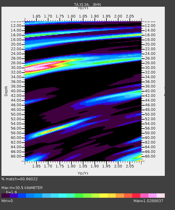
| Estimated Moho Depth: |
30.5 km |
| Estimated Crust Vp/Vs: |
1.60 |
| Assumed Crust Vp: |
6.276 km/s |
| Estimated Crust Vs: |
3.922 km/s |
| Estimated Crust Poisson's Ratio: |
0.18 |
|
| Radial Match: |
80.96022 % |
| Radial Bump: |
400 |
| Transverse Match: |
64.30958 % |
| Transverse Bump: |
400 |
| SOD ConfigId: |
2564 |
| Insert Time: |
2010-03-07 02:19:43.553 +0000 |
| GWidth: |
2.5 |
| Max Bumps: |
400 |
| Tol: |
0.001 |
|

Signal To Noise
| Channel | StoN | STA | LTA |
| TA:X13A: :BHN:20060817T15:31:41.198018Z | 2.1769 | 1.4674212E-7 | 6.7408756E-8 |
| TA:X13A: :BHE:20060817T15:31:41.198018Z | 2.7674572 | 1.6962609E-7 | 6.129312E-8 |
| TA:X13A: :BHZ:20060817T15:31:41.198018Z | 10.089573 | 5.917589E-7 | 5.865054E-8 |
| Arrivals |
| Ps | 3.0 SECOND |
| PpPs | 12 SECOND |
| PsPs/PpSs | 15 SECOND |


