You are here: Home > Network List > TA - USArray Transportable Network (new EarthScope stations) Stations List
> Station X13A Yucca, AZ, USA > Earthquake Result Viewer
X13A Yucca, AZ, USA - Earthquake Result Viewer

| Earthquake location: |
Vanuatu Islands |
| Earthquake latitude/longitude: |
-15.8/167.8 |
| Earthquake time(UTC): |
2006/08/07 (219) 22:18:54 GMT |
| Earthquake Depth: |
141 km |
| Earthquake Magnitude: |
6.0 MB, 6.8 MW, 6.8 MW |
| Earthquake Catalog/Contributor: |
WHDF/NEIC |
|
| Network: |
TA USArray Transportable Network (new EarthScope stations) |
| Station: |
X13A Yucca, AZ, USA |
| Lat/Lon: |
34.59 N/113.83 W |
| Elevation: |
889 m |
|
| Distance: |
89.6 deg |
| Az: |
53.907 deg |
| Baz: |
250.573 deg |
| Ray Param: |
0.041705634 |
| Estimated Moho Depth: |
27.5 km |
| Estimated Crust Vp/Vs: |
1.74 |
| Assumed Crust Vp: |
6.276 km/s |
| Estimated Crust Vs: |
3.607 km/s |
| Estimated Crust Poisson's Ratio: |
0.25 |
|
| Radial Match: |
90.68247 % |
| Radial Bump: |
400 |
| Transverse Match: |
72.33823 % |
| Transverse Bump: |
400 |
| SOD ConfigId: |
2665 |
| Insert Time: |
2010-03-07 02:20:11.962 +0000 |
| GWidth: |
2.5 |
| Max Bumps: |
400 |
| Tol: |
0.001 |
|
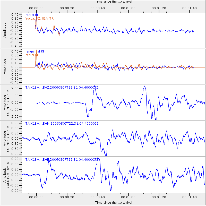
Signal To Noise
| Channel | StoN | STA | LTA |
| TA:X13A: :BHN:20060807T22:31:04.400005Z | 2.6600394 | 1.6848948E-7 | 6.334097E-8 |
| TA:X13A: :BHE:20060807T22:31:04.400005Z | 7.0133314 | 3.5795568E-7 | 5.1039322E-8 |
| TA:X13A: :BHZ:20060807T22:31:04.400005Z | 10.571482 | 9.84647E-7 | 9.3141814E-8 |
| Arrivals |
| Ps | 3.3 SECOND |
| PpPs | 12 SECOND |
| PsPs/PpSs | 15 SECOND |


