You are here: Home > Network List > TA - USArray Transportable Network (new EarthScope stations) Stations List
> Station X13A Yucca, AZ, USA > Earthquake Result Viewer
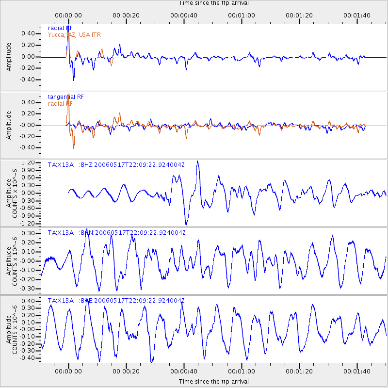
X13A Yucca, AZ, USA - Earthquake Result Viewer

| Earthquake location: |
Tonga Islands |
| Earthquake latitude/longitude: |
-20.6/-174.0 |
| Earthquake time(UTC): |
2006/05/17 (137) 21:57:49 GMT |
| Earthquake Depth: |
10 km |
| Earthquake Magnitude: |
5.3 MB, 5.4 MS, 5.8 MW, 5.5 MW |
| Earthquake Catalog/Contributor: |
WHDF/NEIC |
|
| Network: |
TA USArray Transportable Network (new EarthScope stations) |
| Station: |
X13A Yucca, AZ, USA |
| Lat/Lon: |
34.59 N/113.83 W |
| Elevation: |
889 m |
|
| Distance: |
79.2 deg |
| Az: |
46.744 deg |
| Baz: |
235.788 deg |
| Ray Param: |
0.049104545 |
| Estimated Moho Depth: |
62.5 km |
| Estimated Crust Vp/Vs: |
2.08 |
| Assumed Crust Vp: |
6.276 km/s |
| Estimated Crust Vs: |
3.014 km/s |
| Estimated Crust Poisson's Ratio: |
0.35 |
|
| Radial Match: |
82.64325 % |
| Radial Bump: |
354 |
| Transverse Match: |
75.24909 % |
| Transverse Bump: |
400 |
| SOD ConfigId: |
2669 |
| Insert Time: |
2010-03-07 02:20:20.164 +0000 |
| GWidth: |
2.5 |
| Max Bumps: |
400 |
| Tol: |
0.001 |
|
Signal To Noise
| Channel | StoN | STA | LTA |
| TA:X13A: :BHN:20060517T22:09:22.924004Z | 1.3566445 | 1.4037087E-7 | 1.03469155E-7 |
| TA:X13A: :BHE:20060517T22:09:22.924004Z | 1.6592706 | 2.4035504E-7 | 1.4485583E-7 |
| TA:X13A: :BHZ:20060517T22:09:22.924004Z | 0.7994377 | 1.3326492E-7 | 1.6669833E-7 |
| Arrivals |
| Ps | 11 SECOND |
| PpPs | 30 SECOND |
| PsPs/PpSs | 41 SECOND |


