You are here: Home > Network List > TA - USArray Transportable Network (new EarthScope stations) Stations List
> Station X13A Yucca, AZ, USA > Earthquake Result Viewer
X13A Yucca, AZ, USA - Earthquake Result Viewer
| Earthquake location: |
Andreanof Islands, Aleutian Is. |
| Earthquake latitude/longitude: |
52.2/-178.7 |
| Earthquake time(UTC): |
2008/03/22 (082) 21:24:11 GMT |
| Earthquake Depth: |
132 km |
| Earthquake Magnitude: |
5.8 MB, 6.2 MW, 6.1 MW |
| Earthquake Catalog/Contributor: |
WHDF/NEIC |
|
| Network: |
TA USArray Transportable Network (new EarthScope stations) |
| Station: |
X13A Yucca, AZ, USA |
| Lat/Lon: |
34.59 N/113.83 W |
| Elevation: |
889 m |
|
| Distance: |
48.6 deg |
| Az: |
84.482 deg |
| Baz: |
312.013 deg |
| Ray Param: |
0.068764806 |
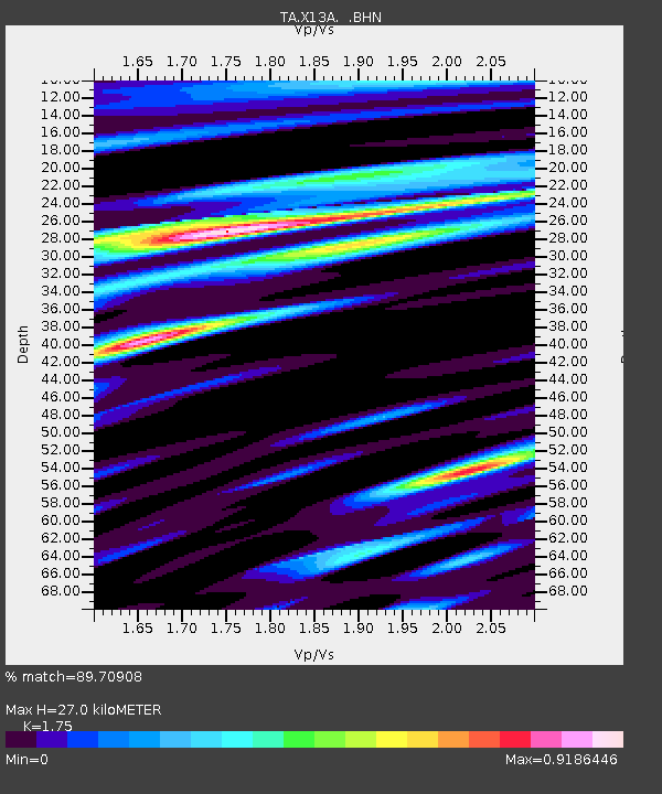
| Estimated Moho Depth: |
27.0 km |
| Estimated Crust Vp/Vs: |
1.75 |
| Assumed Crust Vp: |
6.276 km/s |
| Estimated Crust Vs: |
3.586 km/s |
| Estimated Crust Poisson's Ratio: |
0.26 |
|
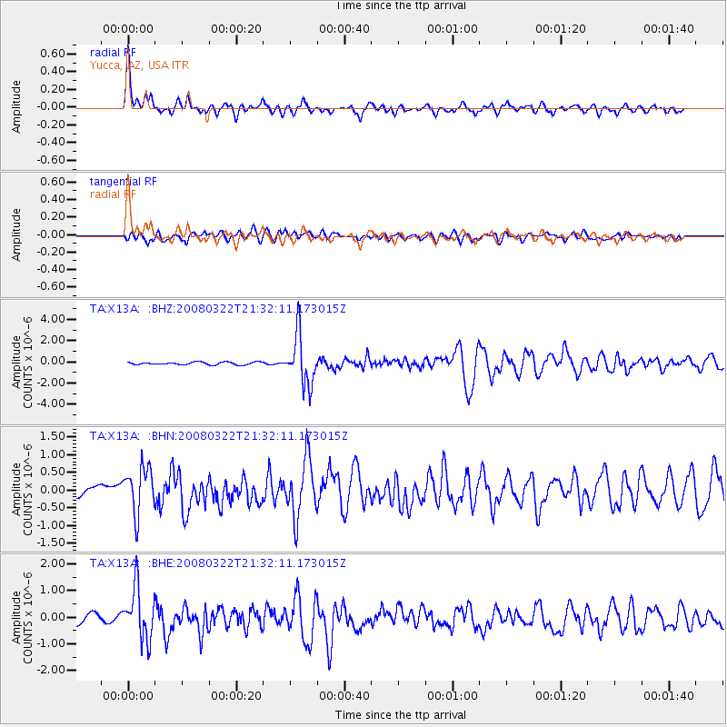
| Radial Match: |
89.70908 % |
| Radial Bump: |
400 |
| Transverse Match: |
68.95516 % |
| Transverse Bump: |
400 |
| SOD ConfigId: |
2564 |
| Insert Time: |
2010-03-07 02:20:44.299 +0000 |
| GWidth: |
2.5 |
| Max Bumps: |
400 |
| Tol: |
0.001 |
|
Signal To Noise
| Channel | StoN | STA | LTA |
| TA:X13A: :BHN:20080322T21:32:11.173015Z | 4.0911655 | 6.5454566E-7 | 1.5999002E-7 |
| TA:X13A: :BHE:20080322T21:32:11.173015Z | 6.80862 | 9.826248E-7 | 1.4432071E-7 |
| TA:X13A: :BHZ:20080322T21:32:11.173015Z | 19.301126 | 2.3721502E-6 | 1.2290216E-7 |
| Arrivals |
| Ps | 3.4 SECOND |
| PpPs | 11 SECOND |
| PsPs/PpSs | 15 SECOND |


