You are here: Home > Network List > TA - USArray Transportable Network (new EarthScope stations) Stations List
> Station L22K Petersville, AK, USA > Earthquake Result Viewer
L22K Petersville, AK, USA - Earthquake Result Viewer
| Earthquake location: |
El Salvador |
| Earthquake latitude/longitude: |
13.3/-89.3 |
| Earthquake time(UTC): |
2019/07/31 (212) 05:54:55 GMT |
| Earthquake Depth: |
72 km |
| Earthquake Magnitude: |
5.9 Mww |
| Earthquake Catalog/Contributor: |
NEIC PDE/us |
|
| Network: |
TA USArray Transportable Network (new EarthScope stations) |
| Station: |
L22K Petersville, AK, USA |
| Lat/Lon: |
62.53 N/150.77 W |
| Elevation: |
817 m |
|
| Distance: |
65.3 deg |
| Az: |
333.361 deg |
| Baz: |
109.733 deg |
| Ray Param: |
0.05818858 |
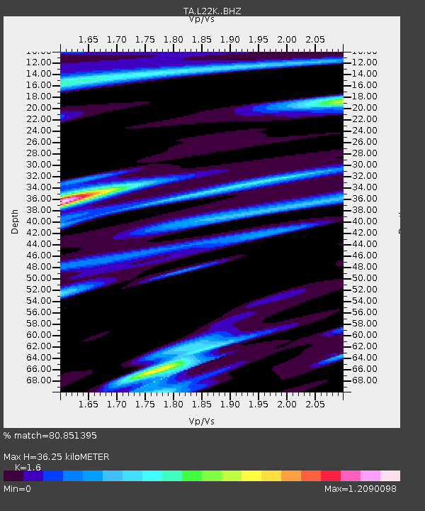
| Estimated Moho Depth: |
36.25 km |
| Estimated Crust Vp/Vs: |
1.60 |
| Assumed Crust Vp: |
6.438 km/s |
| Estimated Crust Vs: |
4.024 km/s |
| Estimated Crust Poisson's Ratio: |
0.18 |
|
| Radial Match: |
80.851395 % |
| Radial Bump: |
400 |
| Transverse Match: |
79.432724 % |
| Transverse Bump: |
400 |
| SOD ConfigId: |
19053131 |
| Insert Time: |
2019-08-14 06:05:16.910 +0000 |
| GWidth: |
2.5 |
| Max Bumps: |
400 |
| Tol: |
0.001 |
|
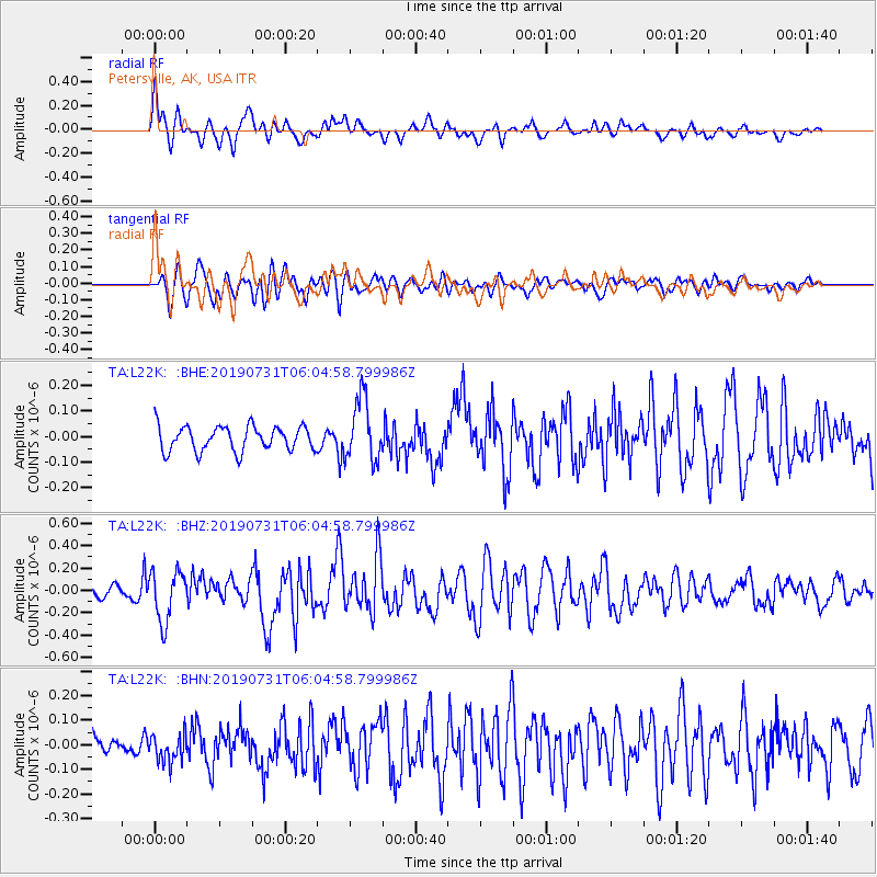
Signal To Noise
| Channel | StoN | STA | LTA |
| TA:L22K: :BHZ:20190731T06:04:58.799986Z | 5.039809 | 2.2545323E-7 | 4.4734477E-8 |
| TA:L22K: :BHN:20190731T06:04:58.799986Z | 1.4178375 | 5.7355745E-8 | 4.0452974E-8 |
| TA:L22K: :BHE:20190731T06:04:58.799986Z | 2.558964 | 1.222642E-7 | 4.7778787E-8 |
| Arrivals |
| Ps | 3.5 SECOND |
| PpPs | 14 SECOND |
| PsPs/PpSs | 18 SECOND |


