You are here: Home > Network List > TA - USArray Transportable Network (new EarthScope stations) Stations List
> Station E03A Lebam, WA, USA > Earthquake Result Viewer
E03A Lebam, WA, USA - Earthquake Result Viewer

| Earthquake location: |
Solomon Islands |
| Earthquake latitude/longitude: |
-9.8/159.5 |
| Earthquake time(UTC): |
2007/08/16 (228) 08:39:27 GMT |
| Earthquake Depth: |
10 km |
| Earthquake Magnitude: |
6.1 MB, 6.7 MS, 6.4 MW |
| Earthquake Catalog/Contributor: |
WHDF/NEIC |
|
| Network: |
TA USArray Transportable Network (new EarthScope stations) |
| Station: |
E03A Lebam, WA, USA |
| Lat/Lon: |
46.55 N/123.56 W |
| Elevation: |
73 m |
|
| Distance: |
88.2 deg |
| Az: |
42.28 deg |
| Baz: |
253.86 deg |
| Ray Param: |
0.042730063 |
| Estimated Moho Depth: |
32.25 km |
| Estimated Crust Vp/Vs: |
1.66 |
| Assumed Crust Vp: |
6.566 km/s |
| Estimated Crust Vs: |
3.961 km/s |
| Estimated Crust Poisson's Ratio: |
0.21 |
|
| Radial Match: |
89.31628 % |
| Radial Bump: |
400 |
| Transverse Match: |
85.5332 % |
| Transverse Bump: |
400 |
| SOD ConfigId: |
2564 |
| Insert Time: |
2010-03-07 02:32:30.530 +0000 |
| GWidth: |
2.5 |
| Max Bumps: |
400 |
| Tol: |
0.001 |
|
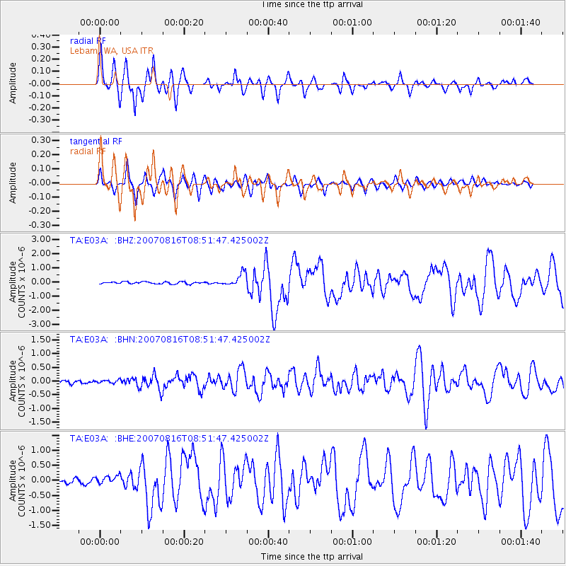
Signal To Noise
| Channel | StoN | STA | LTA |
| TA:E03A: :BHN:20070816T08:51:47.425002Z | 0.8194296 | 6.159153E-8 | 7.51639E-8 |
| TA:E03A: :BHE:20070816T08:51:47.425002Z | 1.7733247 | 1.4070424E-7 | 7.9344886E-8 |
| TA:E03A: :BHZ:20070816T08:51:47.425002Z | 6.4976797 | 4.725811E-7 | 7.273075E-8 |
| Arrivals |
| Ps | 3.3 SECOND |
| PpPs | 13 SECOND |
| PsPs/PpSs | 16 SECOND |


