You are here: Home > Network List > TA - USArray Transportable Network (new EarthScope stations) Stations List
> Station E03A Lebam, WA, USA > Earthquake Result Viewer
E03A Lebam, WA, USA - Earthquake Result Viewer
| Earthquake location: |
Solomon Islands |
| Earthquake latitude/longitude: |
-8.0/154.6 |
| Earthquake time(UTC): |
2007/06/28 (179) 02:52:09 GMT |
| Earthquake Depth: |
10 km |
| Earthquake Magnitude: |
6.3 MB, 6.7 MS, 6.7 MW, 6.7 MW |
| Earthquake Catalog/Contributor: |
WHDF/NEIC |
|
| Network: |
TA USArray Transportable Network (new EarthScope stations) |
| Station: |
E03A Lebam, WA, USA |
| Lat/Lon: |
46.55 N/123.56 W |
| Elevation: |
73 m |
|
| Distance: |
90.1 deg |
| Az: |
43.091 deg |
| Baz: |
258.627 deg |
| Ray Param: |
0.041695476 |
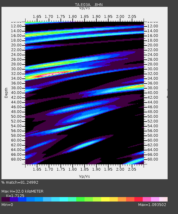
| Estimated Moho Depth: |
32.0 km |
| Estimated Crust Vp/Vs: |
1.71 |
| Assumed Crust Vp: |
6.566 km/s |
| Estimated Crust Vs: |
3.834 km/s |
| Estimated Crust Poisson's Ratio: |
0.24 |
|
| Radial Match: |
81.24992 % |
| Radial Bump: |
400 |
| Transverse Match: |
79.79641 % |
| Transverse Bump: |
400 |
| SOD ConfigId: |
2564 |
| Insert Time: |
2010-03-07 02:32:46.707 +0000 |
| GWidth: |
2.5 |
| Max Bumps: |
400 |
| Tol: |
0.001 |
|

Signal To Noise
| Channel | StoN | STA | LTA |
| TA:E03A: :BHN:20070628T03:04:38.275Z | 1.5518907 | 2.2326032E-7 | 1.4386343E-7 |
| TA:E03A: :BHE:20070628T03:04:38.275Z | 2.892515 | 4.2017976E-7 | 1.4526451E-7 |
| TA:E03A: :BHZ:20070628T03:04:38.275Z | 13.453684 | 1.3434822E-6 | 9.98598E-8 |
| Arrivals |
| Ps | 3.6 SECOND |
| PpPs | 13 SECOND |
| PsPs/PpSs | 16 SECOND |


