You are here: Home > Network List > TA - USArray Transportable Network (new EarthScope stations) Stations List
> Station E03A Lebam, WA, USA > Earthquake Result Viewer
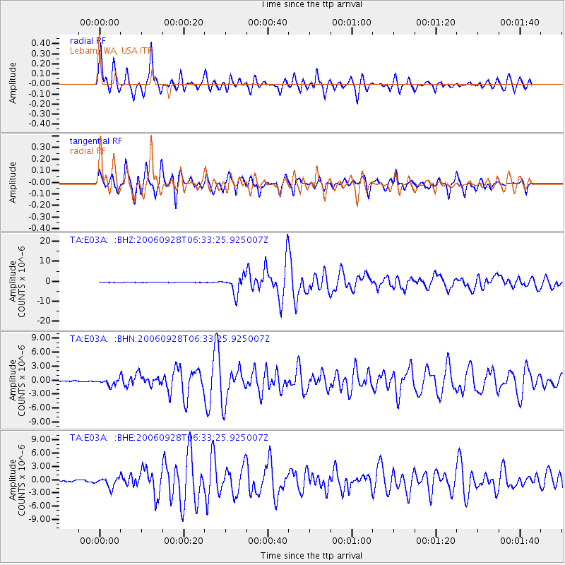
E03A Lebam, WA, USA - Earthquake Result Viewer

| Earthquake location: |
Samoa Islands Region |
| Earthquake latitude/longitude: |
-16.6/-172.0 |
| Earthquake time(UTC): |
2006/09/28 (271) 06:22:09 GMT |
| Earthquake Depth: |
28 km |
| Earthquake Magnitude: |
6.5 MB, 6.6 MS, 6.9 MW, 6.7 MW |
| Earthquake Catalog/Contributor: |
WHDF/NEIC |
|
| Network: |
TA USArray Transportable Network (new EarthScope stations) |
| Station: |
E03A Lebam, WA, USA |
| Lat/Lon: |
46.55 N/123.56 W |
| Elevation: |
73 m |
|
| Distance: |
76.5 deg |
| Az: |
32.098 deg |
| Baz: |
227.58 deg |
| Ray Param: |
0.050916556 |
| Estimated Moho Depth: |
31.5 km |
| Estimated Crust Vp/Vs: |
1.64 |
| Assumed Crust Vp: |
6.566 km/s |
| Estimated Crust Vs: |
4.01 km/s |
| Estimated Crust Poisson's Ratio: |
0.20 |
|
| Radial Match: |
91.05178 % |
| Radial Bump: |
400 |
| Transverse Match: |
82.603546 % |
| Transverse Bump: |
368 |
| SOD ConfigId: |
2564 |
| Insert Time: |
2010-03-07 02:33:04.291 +0000 |
| GWidth: |
2.5 |
| Max Bumps: |
400 |
| Tol: |
0.001 |
|
Signal To Noise
| Channel | StoN | STA | LTA |
| TA:E03A: :BHN:20060928T06:33:25.925007Z | 3.9691417 | 6.6224595E-7 | 1.6684865E-7 |
| TA:E03A: :BHE:20060928T06:33:25.925007Z | 8.564129 | 1.1252906E-6 | 1.3139582E-7 |
| TA:E03A: :BHZ:20060928T06:33:25.925007Z | 33.523853 | 4.4300773E-6 | 1.3214702E-7 |
| Arrivals |
| Ps | 3.2 SECOND |
| PpPs | 12 SECOND |
| PsPs/PpSs | 15 SECOND |


