You are here: Home > Network List > TA - USArray Transportable Network (new EarthScope stations) Stations List
> Station E03A Lebam, WA, USA > Earthquake Result Viewer
E03A Lebam, WA, USA - Earthquake Result Viewer
| Earthquake location: |
Tonga Islands |
| Earthquake latitude/longitude: |
-15.2/-173.6 |
| Earthquake time(UTC): |
2006/07/07 (188) 07:26:12 GMT |
| Earthquake Depth: |
35 km |
| Earthquake Magnitude: |
5.7 MB, 5.9 MS, 6.0 MW, 6.0 MW |
| Earthquake Catalog/Contributor: |
WHDF/NEIC |
|
| Network: |
TA USArray Transportable Network (new EarthScope stations) |
| Station: |
E03A Lebam, WA, USA |
| Lat/Lon: |
46.55 N/123.56 W |
| Elevation: |
73 m |
|
| Distance: |
76.2 deg |
| Az: |
33.014 deg |
| Baz: |
229.639 deg |
| Ray Param: |
0.051111717 |
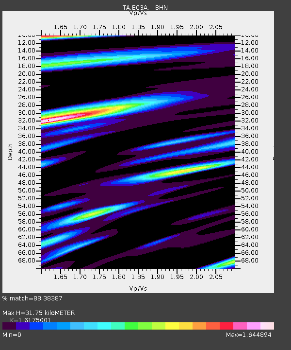
| Estimated Moho Depth: |
31.75 km |
| Estimated Crust Vp/Vs: |
1.62 |
| Assumed Crust Vp: |
6.566 km/s |
| Estimated Crust Vs: |
4.059 km/s |
| Estimated Crust Poisson's Ratio: |
0.19 |
|
| Radial Match: |
88.38387 % |
| Radial Bump: |
400 |
| Transverse Match: |
77.2823 % |
| Transverse Bump: |
400 |
| SOD ConfigId: |
2665 |
| Insert Time: |
2010-03-07 02:33:22.453 +0000 |
| GWidth: |
2.5 |
| Max Bumps: |
400 |
| Tol: |
0.001 |
|
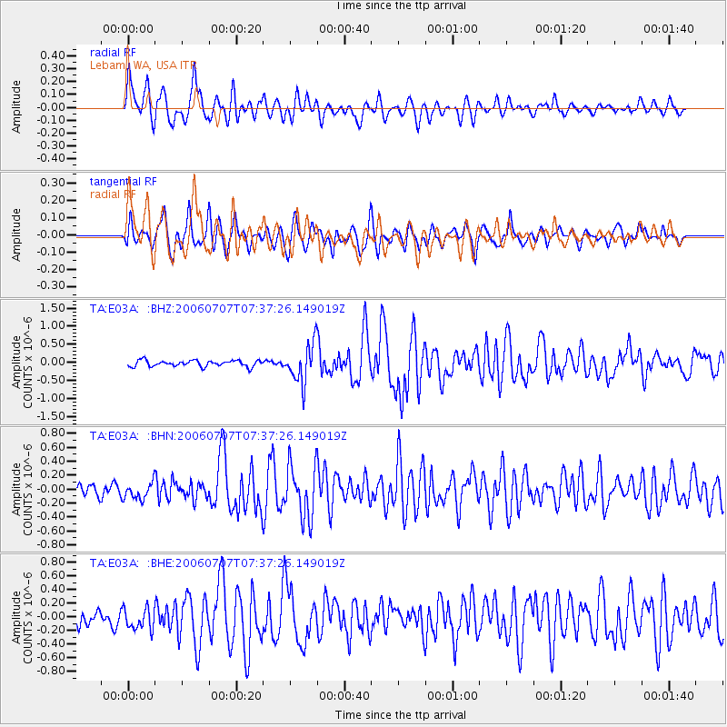
Signal To Noise
| Channel | StoN | STA | LTA |
| TA:E03A: :BHN:20060707T07:37:26.149019Z | 1.1910142 | 1.17192904E-7 | 9.839758E-8 |
| TA:E03A: :BHE:20060707T07:37:26.149019Z | 1.6021658 | 1.5452581E-7 | 9.6448076E-8 |
| TA:E03A: :BHZ:20060707T07:37:26.149019Z | 6.4898 | 5.4795134E-7 | 8.44327E-8 |
| Arrivals |
| Ps | 3.1 SECOND |
| PpPs | 12 SECOND |
| PsPs/PpSs | 15 SECOND |


