You are here: Home > Network List > TA - USArray Transportable Network (new EarthScope stations) Stations List
> Station E03A Lebam, WA, USA > Earthquake Result Viewer
E03A Lebam, WA, USA - Earthquake Result Viewer
| Earthquake location: |
Fiji Islands Region |
| Earthquake latitude/longitude: |
-16.5/177.0 |
| Earthquake time(UTC): |
2006/04/07 (097) 08:30:45 GMT |
| Earthquake Depth: |
22 km |
| Earthquake Magnitude: |
5.9 MB, 6.4 MS, 6.4 MW, 6.4 MW |
| Earthquake Catalog/Contributor: |
WHDF/NEIC |
|
| Network: |
TA USArray Transportable Network (new EarthScope stations) |
| Station: |
E03A Lebam, WA, USA |
| Lat/Lon: |
46.55 N/123.56 W |
| Elevation: |
73 m |
|
| Distance: |
82.4 deg |
| Az: |
36.845 deg |
| Baz: |
236.442 deg |
| Ray Param: |
0.046870377 |
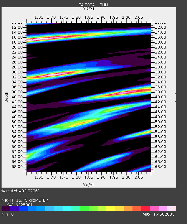
| Estimated Moho Depth: |
16.75 km |
| Estimated Crust Vp/Vs: |
1.62 |
| Assumed Crust Vp: |
6.566 km/s |
| Estimated Crust Vs: |
4.047 km/s |
| Estimated Crust Poisson's Ratio: |
0.19 |
|
| Radial Match: |
83.37961 % |
| Radial Bump: |
400 |
| Transverse Match: |
77.866394 % |
| Transverse Bump: |
400 |
| SOD ConfigId: |
2669 |
| Insert Time: |
2010-03-07 02:33:37.037 +0000 |
| GWidth: |
2.5 |
| Max Bumps: |
400 |
| Tol: |
0.001 |
|
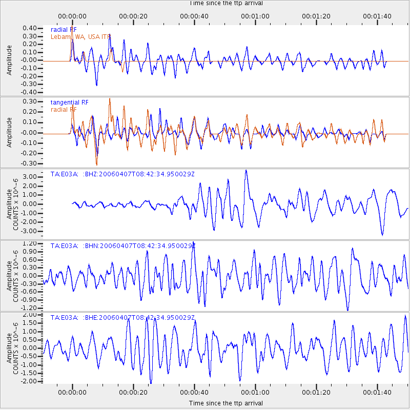
Signal To Noise
| Channel | StoN | STA | LTA |
| TA:E03A: :BHN:20060407T08:42:34.950029Z | 1.3629532 | 3.032419E-7 | 2.2248886E-7 |
| TA:E03A: :BHE:20060407T08:42:34.950029Z | 1.3924791 | 3.8626266E-7 | 2.7739208E-7 |
| TA:E03A: :BHZ:20060407T08:42:34.950029Z | 1.9902823 | 4.0440827E-7 | 2.031914E-7 |
| Arrivals |
| Ps | 1.6 SECOND |
| PpPs | 6.5 SECOND |
| PsPs/PpSs | 8.1 SECOND |


