You are here: Home > Network List > TA - USArray Transportable Network (new EarthScope stations) Stations List
> Station E03A Lebam, WA, USA > Earthquake Result Viewer
E03A Lebam, WA, USA - Earthquake Result Viewer
| Earthquake location: |
South Of Fiji Islands |
| Earthquake latitude/longitude: |
-23.6/-180.0 |
| Earthquake time(UTC): |
2006/02/26 (057) 03:08:27 GMT |
| Earthquake Depth: |
535 km |
| Earthquake Magnitude: |
5.9 MB, 6.4 MW, 6.4 MW |
| Earthquake Catalog/Contributor: |
WHDF/NEIC |
|
| Network: |
TA USArray Transportable Network (new EarthScope stations) |
| Station: |
E03A Lebam, WA, USA |
| Lat/Lon: |
46.55 N/123.56 W |
| Elevation: |
73 m |
|
| Distance: |
86.4 deg |
| Az: |
35.181 deg |
| Baz: |
229.972 deg |
| Ray Param: |
0.042537957 |
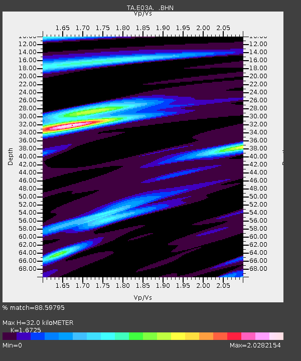
| Estimated Moho Depth: |
32.0 km |
| Estimated Crust Vp/Vs: |
1.67 |
| Assumed Crust Vp: |
6.566 km/s |
| Estimated Crust Vs: |
3.926 km/s |
| Estimated Crust Poisson's Ratio: |
0.22 |
|
| Radial Match: |
88.59795 % |
| Radial Bump: |
400 |
| Transverse Match: |
81.042244 % |
| Transverse Bump: |
400 |
| SOD ConfigId: |
2422 |
| Insert Time: |
2010-03-07 02:33:38.719 +0000 |
| GWidth: |
2.5 |
| Max Bumps: |
400 |
| Tol: |
0.001 |
|
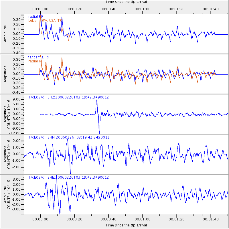
Signal To Noise
| Channel | StoN | STA | LTA |
| TA:E03A: :BHN:20060226T03:19:42.349001Z | 2.5736394 | 6.0391255E-7 | 2.3465313E-7 |
| TA:E03A: :BHE:20060226T03:19:42.349001Z | 3.9512715 | 1.108575E-6 | 2.8056158E-7 |
| TA:E03A: :BHZ:20060226T03:19:42.349001Z | 11.080747 | 4.369828E-6 | 3.9436222E-7 |
| Arrivals |
| Ps | 3.4 SECOND |
| PpPs | 13 SECOND |
| PsPs/PpSs | 16 SECOND |


