You are here: Home > Network List > IC - New China Digital Seismograph Network Stations List
> Station HIA Hailar, Neimenggu Autonomous Region, China > Earthquake Result Viewer
HIA Hailar, Neimenggu Autonomous Region, China - Earthquake Result Viewer
| Earthquake location: |
Vanuatu Islands |
| Earthquake latitude/longitude: |
-16.2/167.9 |
| Earthquake time(UTC): |
2019/07/31 (212) 15:02:33 GMT |
| Earthquake Depth: |
179 km |
| Earthquake Magnitude: |
6.6 mww |
| Earthquake Catalog/Contributor: |
NEIC PDE/us |
|
| Network: |
IC New China Digital Seismograph Network |
| Station: |
HIA Hailar, Neimenggu Autonomous Region, China |
| Lat/Lon: |
49.27 N/119.74 E |
| Elevation: |
620 m |
|
| Distance: |
77.9 deg |
| Az: |
330.032 deg |
| Baz: |
132.875 deg |
| Ray Param: |
0.04959012 |
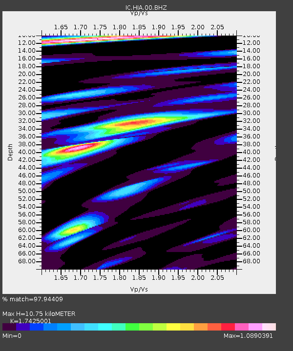
| Estimated Moho Depth: |
10.75 km |
| Estimated Crust Vp/Vs: |
1.74 |
| Assumed Crust Vp: |
6.577 km/s |
| Estimated Crust Vs: |
3.774 km/s |
| Estimated Crust Poisson's Ratio: |
0.25 |
|
| Radial Match: |
97.94409 % |
| Radial Bump: |
386 |
| Transverse Match: |
89.47419 % |
| Transverse Bump: |
400 |
| SOD ConfigId: |
19053131 |
| Insert Time: |
2019-08-14 15:07:59.159 +0000 |
| GWidth: |
2.5 |
| Max Bumps: |
400 |
| Tol: |
0.001 |
|

Signal To Noise
| Channel | StoN | STA | LTA |
| IC:HIA:00:BHZ:20190731T15:13:40.218995Z | 38.099228 | 2.113968E-6 | 5.5485856E-8 |
| IC:HIA:00:BH1:20190731T15:13:40.218995Z | 19.246708 | 7.4939464E-7 | 3.8936253E-8 |
| IC:HIA:00:BH2:20190731T15:13:40.218995Z | 25.651243 | 6.8959713E-7 | 2.6883574E-8 |
| Arrivals |
| Ps | 1.3 SECOND |
| PpPs | 4.3 SECOND |
| PsPs/PpSs | 5.6 SECOND |


