You are here: Home > Network List > NM - Cooperative New Madrid Seismic Network Stations List
> Station HDBT Mud Island,Memphis,TN(CERI) > Earthquake Result Viewer
HDBT Mud Island,Memphis,TN(CERI) - Earthquake Result Viewer

| Earthquake location: |
Southern Chile |
| Earthquake latitude/longitude: |
-43.3/-74.5 |
| Earthquake time(UTC): |
2016/12/25 (360) 14:22:28 GMT |
| Earthquake Depth: |
15 km |
| Earthquake Magnitude: |
7.7 Mi |
| Earthquake Catalog/Contributor: |
NEIC PDE/at |
|
| Network: |
NM Cooperative New Madrid Seismic Network |
| Station: |
HDBT Mud Island,Memphis,TN(CERI) |
| Lat/Lon: |
35.15 N/90.06 W |
| Elevation: |
66 m |
|
| Distance: |
79.4 deg |
| Az: |
347.078 deg |
| Baz: |
168.508 deg |
| Ray Param: |
0.049004655 |
| Estimated Moho Depth: |
15.25 km |
| Estimated Crust Vp/Vs: |
1.62 |
| Assumed Crust Vp: |
6.273 km/s |
| Estimated Crust Vs: |
3.878 km/s |
| Estimated Crust Poisson's Ratio: |
0.19 |
|
| Radial Match: |
92.92889 % |
| Radial Bump: |
394 |
| Transverse Match: |
79.23943 % |
| Transverse Bump: |
400 |
| SOD ConfigId: |
1894071 |
| Insert Time: |
2017-01-08 14:31:09.192 +0000 |
| GWidth: |
2.5 |
| Max Bumps: |
400 |
| Tol: |
0.001 |
|
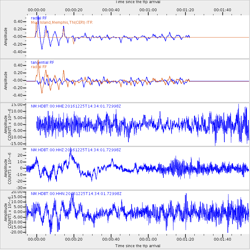
Signal To Noise
| Channel | StoN | STA | LTA |
| NM:HDBT:00:HHZ:20161225T14:34:01.72998Z | 2.5838044 | 8.345082E-6 | 3.2297653E-6 |
| NM:HDBT:00:HHN:20161225T14:34:01.72998Z | 1.2952515 | 5.7983093E-6 | 4.4765898E-6 |
| NM:HDBT:00:HHE:20161225T14:34:01.72998Z | 0.8292451 | 3.4263646E-6 | 4.131908E-6 |
| Arrivals |
| Ps | 1.5 SECOND |
| PpPs | 6.2 SECOND |
| PsPs/PpSs | 7.7 SECOND |


