
Station NM HDBT - Mud Island,Memphis,TN(CERI)
Network: NM - Cooperative New Madrid Seismic Network
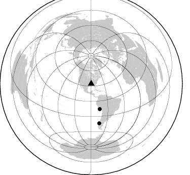
Nearby stations (2 deg radius)
| Station | Name | (Lat, Lon) | Start / End | Elevation |
| HDBT | Mud Island,Memphis,TN(CERI) | (35.15, -90.06) | 2001-08-21 / 2599-12-31 | 66 m |
| Crust2 Type: | DD,Platform 5.0 km seds. |
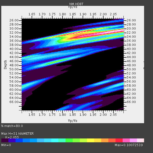
| Thickness Estimate: | 31 km |
| Thickness StdDev: | 1.8 km |
| Vp/Vs Estimate: | 2.06 |
| Vp/Vs StdDev: | 0.09 |
| Vs Estimate: | 3.053 km/s |
| Poisson's Ratio: | 0.34 |
| Peak Value: | 0.10 |
| Assumed Vp: | 6.273 km/s |
| Ps Weight: | 0.33333334 |
| PpPs Weight: | 0.33333334 |
| PsPs Weight: | 0.33333328 |
| Residual Complexity: | 0.723 |
| Nearby stations H: | +- |
| (2.0 deg) Vp/Vs: | +- |
1 with match > 90% ( 6.25 %) and 2 with match > 80% ( 12.5 %) out of 16.
Download stack as xyz text file.
Azimuth Distribution of Events:
Prior Results for this Station
| Study | Thickness | Vp/Vs | Vp | Vs | Poissons Ratio | Extra |
| EARS | 31 km | 2.06 | 6.273 km/s | 3.053 km/s | 0.34 | |
| Crust2.0 | 41 km | 1.78 | 6.273 km/s | 3.524 km/s | 0.27 | DD,Platform 5.0 km seds. |
| Global Maxima | 31 km | 2.06 | 6.273 km/s | 3.053 km/s | 0.34 | amp=0.10072539 |
| Local Maxima 1 | 32 km | 1.89 | 6.273 km/s | 3.324 km/s | 0.30 | amp=0.08689311 |
| Local Maxima 2 | 34 km | 1.90 | 6.273 km/s | 3.293 km/s | 0.31 | amp=0.05645613 |
| Local Maxima 3 | 46 km | 1.76 | 6.273 km/s | 3.569 km/s | 0.26 | amp=0.053995524 |
| Local Maxima 4 | 34 km | 2.08 | 6.273 km/s | 3.023 km/s | 0.35 | amp=0.05128727 |
| Predicted Arrivals for vertical incidence (zero ray parameter) | |
| Ps | 5.21 SECOND |
| PpPs | 15.10 SECOND |
| PsPs/PpSs | 20.31 SECOND |
Events Processed for this Station
Download zip of receiver functions as SAC
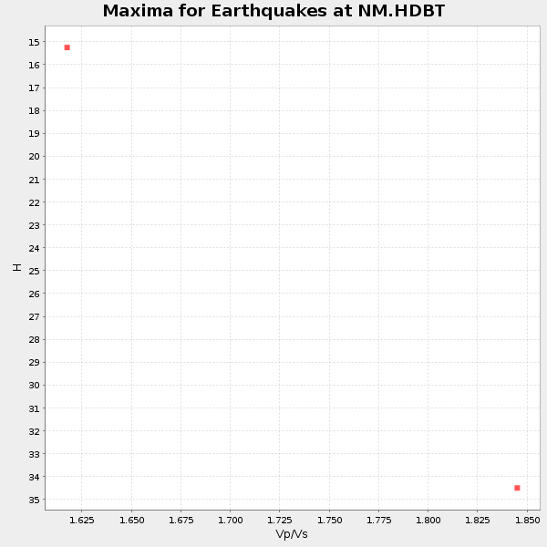
Plot maxima for each earthquake.
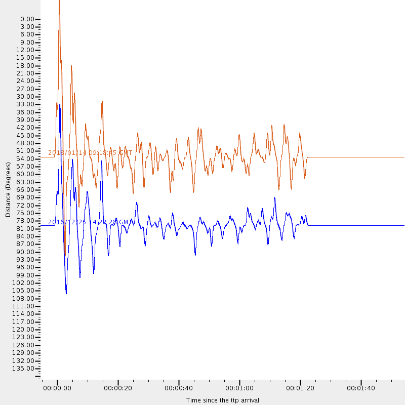
Events Used in the Stack
(2 events)| Radial Match | Distance | Baz | FERegion | Time | Lat/Lon | Depth | Magnitude |
| 92.92889 | 79.4 deg | 168.508 deg | Southern Chile | 2016/12/25 14:22:28 GMT | (-43.3, -74.5) | 15 km | 7.7 Mi |
| 89.90463 | 52.7 deg | 161.356 deg | Near Coast Of Peru | 2018/01/14 09:18:45 GMT | (-15.8, -74.7) | 36 km | 7.1 mww |
Losers
(14 events)| Radial Match | Distance | Baz | FERegion | Time | Lat/Lon | Depth | Magnitude | Reason |
| 77.74272 | 68.7 deg | 163.499 deg | Near Coast Of Central Chile | 2015/09/16 23:38:05 GMT | (-31.8, -72.0) | 35 km | 5.7 MB | |
| 68.990204 | 93.6 deg | 321.354 deg | Near East Coast Of Honshu, Japan | 2016/11/23 21:23:37 GMT | (37.2, 141.3) | 10 km | 5.6 MB | |
| 68.467636 | 57.0 deg | 313.924 deg | Fox Islands, Aleutian Islands | 2015/11/06 01:09:55 GMT | (52.3, -169.5) | 10 km | 5.5 MB, 5.0 ML | |
| 63.14072 | 77.7 deg | 321.755 deg | East Of Kuril Islands | 2015/10/14 05:43:07 GMT | (48.9, 156.2) | 6.0 km | 5.6 MB, 5.9 MWB | |
| 61.695038 | 72.7 deg | 166.228 deg | Near Coast Of Central Chile | 2015/06/20 05:22:19 GMT | (-36.3, -73.7) | 30 km | 5.5 MWR | |
| 61.11625 | 79.1 deg | 322.198 deg | Kuril Islands | 2015/11/16 16:49:15 GMT | (48.3, 154.3) | 42 km | 5.8 MWB | |
| 56.128544 | 68.9 deg | 163.178 deg | Near Coast Of Central Chile | 2015/09/16 23:03:56 GMT | (-31.8, -71.6) | 10 km | 6.1 MB | |
| 54.767677 | 56.9 deg | 313.946 deg | Fox Islands, Aleutian Islands | 2015/07/27 07:40:31 GMT | (52.3, -169.3) | 31 km | 5.6 MB, 5.0 ML, 5.6 MI | |
| 54.22992 | 86.4 deg | 322.421 deg | Kuril Islands | 2015/11/28 02:51:06 GMT | (43.3, 146.5) | 60 km | 5.9 MB | |
| 52.239967 | 31.5 deg | 119.557 deg | Leeward Islands | 2014/12/19 19:49:29 GMT | (16.2, -61.8) | 114 km | 5.6 MWW, 5.6 MWB | |
| 52.03006 | 62.8 deg | 155.753 deg | Jujuy Province, Argentina | 2014/09/24 11:16:12 GMT | (-23.9, -66.6) | 189 km | 6.2 MWP, 6.2 MWB, 6.2 MWC | |
| 50.864746 | 45.5 deg | 164.436 deg | Near Coast Of Northern Peru | 2017/01/28 06:42:32 GMT | (-9.3, -78.9) | 46 km | 5.3 Mww | |
| 47.781868 | 90.8 deg | 321.771 deg | Off East Coast Of Honshu, Japan | 2015/02/24 02:28:54 GMT | (39.7, 143.2) | 20 km | 5.8 MWB, 5.6 MWR, 5.8 MWC | |
| 41.532063 | 59.3 deg | 313.819 deg | Andreanof Islands, Aleutian Is. | 2015/11/08 10:46:17 GMT | (51.5, -172.9) | 16 km | 5.6 MWW, 5.5 MWB, 5.5 MI, 5.7 MWC |

