You are here: Home > Network List > BX - Botswana Seismological Network Stations List
> Station GMARE Gumare > Earthquake Result Viewer
GMARE Gumare - Earthquake Result Viewer
| Earthquake location: |
Southwest Of Sumatra, Indonesia |
| Earthquake latitude/longitude: |
-7.3/104.8 |
| Earthquake time(UTC): |
2019/08/02 (214) 12:03:26 GMT |
| Earthquake Depth: |
43 km |
| Earthquake Magnitude: |
6.8 Mww |
| Earthquake Catalog/Contributor: |
NEIC PDE/us |
|
| Network: |
BX Botswana Seismological Network |
| Station: |
GMARE Gumare |
| Lat/Lon: |
19.39 S/22.16 E |
| Elevation: |
985 m |
|
| Distance: |
80.7 deg |
| Az: |
251.561 deg |
| Baz: |
94.479 deg |
| Ray Param: |
0.048026845 |
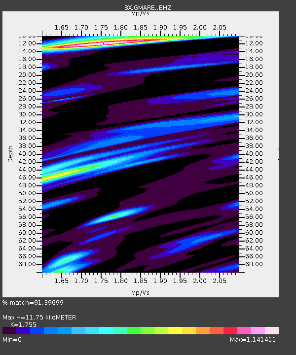
| Estimated Moho Depth: |
11.75 km |
| Estimated Crust Vp/Vs: |
1.75 |
| Assumed Crust Vp: |
6.516 km/s |
| Estimated Crust Vs: |
3.713 km/s |
| Estimated Crust Poisson's Ratio: |
0.26 |
|
| Radial Match: |
91.39699 % |
| Radial Bump: |
400 |
| Transverse Match: |
79.84129 % |
| Transverse Bump: |
400 |
| SOD ConfigId: |
19053131 |
| Insert Time: |
2019-08-16 12:05:47.980 +0000 |
| GWidth: |
2.5 |
| Max Bumps: |
400 |
| Tol: |
0.001 |
|

Signal To Noise
| Channel | StoN | STA | LTA |
| BX:GMARE: :BHZ:20190802T12:15:04.309022Z | 6.6760135 | 1.6360666E-6 | 2.4506642E-7 |
| BX:GMARE: :BHN:20190802T12:15:04.309022Z | 1.2955229 | 2.680031E-7 | 2.0686868E-7 |
| BX:GMARE: :BHE:20190802T12:15:04.309022Z | 4.0614195 | 1.0423877E-6 | 2.56656E-7 |
| Arrivals |
| Ps | 1.4 SECOND |
| PpPs | 4.8 SECOND |
| PsPs/PpSs | 6.2 SECOND |


