
Station BX GMARE - Gumare
Network: BX - Botswana Seismological Network
Nearby stations (2 deg radius)
| Station | Name | (Lat, Lon) | Start / End | Elevation |
| GMARE | Gumare | (-19.39, 22.16) | 2018-02-17 / 2599-12-31 | 985 m |
| Crust2 Type: | H4,early/mid Proter. shield, Africa, 1.5 km seds. |
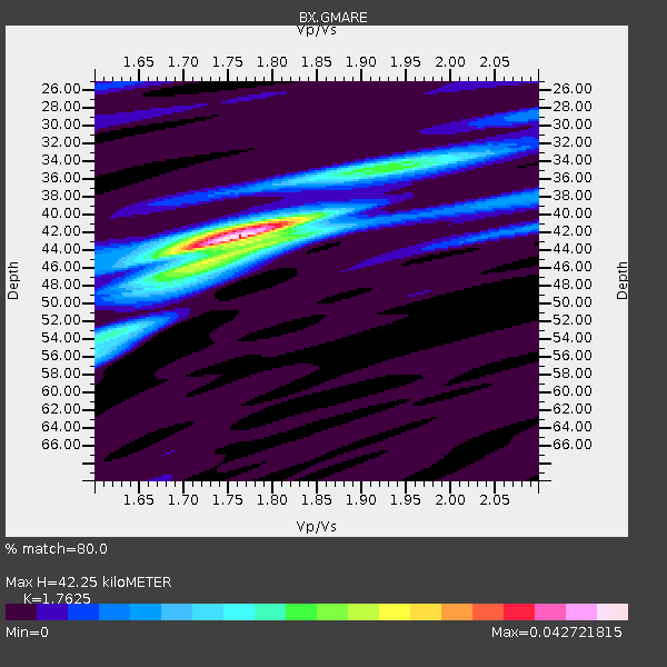
| Thickness Estimate: | 42 km |
| Thickness StdDev: | 2.3 km |
| Vp/Vs Estimate: | 1.76 |
| Vp/Vs StdDev: | 0.05 |
| Vs Estimate: | 3.697 km/s |
| Poisson's Ratio: | 0.26 |
| Peak Value: | 0.04 |
| Assumed Vp: | 6.516 km/s |
| Ps Weight: | 0.33333334 |
| PpPs Weight: | 0.33333334 |
| PsPs Weight: | 0.33333328 |
| Residual Complexity: | 0.491 |
| Nearby stations H: | 43 km +- 1.4 km |
| (2.0 deg) Vp/Vs: | 1.74 +- 0.02 |
5 with match > 90% ( 13.157895 %) and 10 with match > 80% ( 26.31579 %) out of 38.
Download stack as xyz text file.
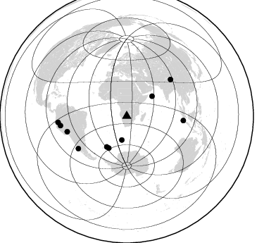
Azimuth Distribution of Events:
Prior Results for this Station
| Study | Thickness | Vp/Vs | Vp | Vs | Poissons Ratio | Extra |
| EARS | 42 km | 1.76 | 6.516 km/s | 3.697 km/s | 0.26 | |
| Crust2.0 | 46 km | 1.78 | 6.516 km/s | 3.661 km/s | 0.27 | H4,early/mid Proter. shield, Africa, 1.5 km seds. |
| Global Maxima | 42 km | 1.76 | 6.516 km/s | 3.697 km/s | 0.26 | amp=0.042721815 |
| Local Maxima 1 | 46 km | 1.71 | 6.516 km/s | 3.805 km/s | 0.24 | amp=0.017441237 |
| Local Maxima 2 | 34 km | 1.96 | 6.516 km/s | 3.333 km/s | 0.32 | amp=0.014707532 |
| Local Maxima 3 | 53 km | 1.62 | 6.516 km/s | 4.022 km/s | 0.19 | amp=0.013361945 |
| Local Maxima 4 | 41 km | 1.76 | 6.516 km/s | 3.697 km/s | 0.26 | amp=0.00963126 |
| Predicted Arrivals for vertical incidence (zero ray parameter) | |
| Ps | 4.94 SECOND |
| PpPs | 17.91 SECOND |
| PsPs/PpSs | 22.86 SECOND |
Events Processed for this Station
Download zip of receiver functions as SAC
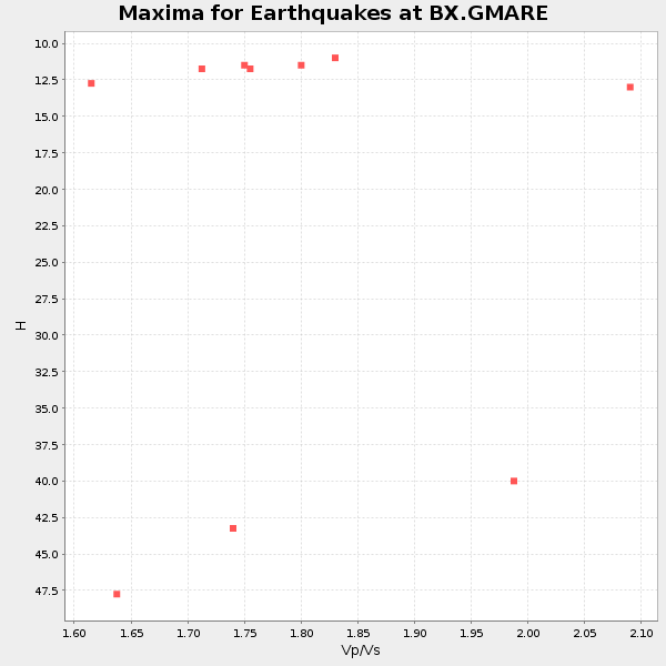
Plot maxima for each earthquake.
Events Used in the Stack
(10 events)| Radial Match | Distance | Baz | FERegion | Time | Lat/Lon | Depth | Magnitude |
| 94.13844 | 97.9 deg | 264.867 deg | Peru-Ecuador Border Region | 2019/02/22 10:17:22 UTC | (-2.2, -77.0) | 132 km | 7.5 mww |
| 92.22293 | 82.9 deg | 236.346 deg | Near Coast Of Central Chile | 2019/08/01 18:28:05 UTC | (-34.2, -72.3) | 10 km | 6.8 mww |
| 91.39699 | 80.7 deg | 94.479 deg | Southwest Of Sumatra, Indonesia | 2019/08/02 12:03:26 UTC | (-7.3, 104.8) | 43 km | 6.8 Mww |
| 90.39119 | 95.1 deg | 261.977 deg | Northern Peru | 2019/05/26 07:41:13 UTC | (-5.9, -75.3) | 105 km | 7.5 Mi |
| 90.28114 | 45.8 deg | 51.925 deg | Carlsberg Ridge | 2019/04/29 14:19:52 UTC | (10.9, 57.2) | 10 km | 6.3 Mww |
| 88.9376 | 52.0 deg | 209.302 deg | South Sandwich Islands Region | 2019/04/09 17:53:59 UTC | (-58.6, -25.3) | 46 km | 6.5 Mww |
| 82.9095 | 52.1 deg | 213.116 deg | South Sandwich Islands Region | 2019/04/05 16:14:16 UTC | (-55.9, -27.8) | 58 km | 6.5 mww |
| 82.04061 | 34.4 deg | 191.541 deg | Southwest Of Africa | 2019/12/09 17:59:47 UTC | (-52.8, 11.4) | 10 km | 5.6 Mww |
| 81.89914 | 80.8 deg | 50.199 deg | Xizang | 2020/07/22 20:07:19 UTC | (33.1, 86.8) | 10 km | 6.3 mww |
| 81.60764 | 87.3 deg | 255.474 deg | Central Peru | 2019/03/01 08:50:41 UTC | (-14.7, -70.1) | 257 km | 7.0 mww |
Losers
(28 events)| Radial Match | Distance | Baz | FERegion | Time | Lat/Lon | Depth | Magnitude | Reason |
| 77.72437 | 43.9 deg | 83.78 deg | Mid-Indian Ridge | 2019/03/30 06:27:23 UTC | (-9.7, 66.5) | 10 km | 5.9 Mww | |
| 77.42817 | 52.0 deg | 212.586 deg | South Sandwich Islands Region | 2019/04/22 14:49:06 UTC | (-56.3, -27.4) | 94 km | 6.0 Mww | |
| 77.312935 | 39.7 deg | 293.027 deg | North Of Ascension Island | 2019/10/23 16:08:14 UTC | (-1.1, -13.8) | 10 km | 6.3 mww | |
| 76.61372 | 84.1 deg | 240.371 deg | Off Coast Of Central Chile | 2019/06/14 00:19:10 UTC | (-30.0, -72.2) | 10 km | 6.5 Mww | |
| 72.478455 | 57.5 deg | 7.062 deg | Turkey | 2019/08/08 11:25:31 UTC | (37.9, 29.7) | 10 km | 5.8 Mww | |
| 68.92427 | 77.3 deg | 88.319 deg | Southern Sumatra, Indonesia | 2019/10/21 23:49:04 UTC | (-2.6, 99.6) | 10 km | 5.2 Mww | |
| 66.08889 | 40.3 deg | 200.872 deg | Bouvet Island Region | 2019/03/06 05:11:02 UTC | (-55.4, -1.7) | 10 km | 5.3 Mww | |
| 65.01832 | 51.5 deg | 212.142 deg | South Sandwich Islands Region | 2019/10/13 06:09:02 UTC | (-56.4, -26.3) | 15 km | 5.5 mb | |
| 64.186165 | 87.7 deg | 95.583 deg | Java, Indonesia | 2019/09/19 07:06:33 UTC | (-6.1, 111.9) | 612 km | 6.2 Mww | |
| 63.134396 | 52.2 deg | 212.631 deg | South Sandwich Islands Region | 2019/05/27 23:29:31 UTC | (-56.3, -27.8) | 111 km | 5.7 Mww | |
| 62.759506 | 53.1 deg | 116.501 deg | Broken Ridge | 2019/11/13 14:17:17 UTC | (-32.5, 80.1) | 10 km | 5.5 mb | |
| 61.855083 | 86.7 deg | 68.189 deg | Laos | 2019/11/20 23:50:44 UTC | (19.5, 101.3) | 10 km | 6.1 Mww | |
| 60.25592 | 56.2 deg | 35.513 deg | Southern Iran | 2019/10/21 10:58:52 UTC | (27.2, 55.0) | 10 km | 5.4 Mww | |
| 59.966183 | 87.7 deg | 95.622 deg | Java, Indonesia | 2019/09/19 07:32:00 UTC | (-6.1, 111.9) | 591 km | 6.0 Mww | |
| 56.817238 | 48.3 deg | 75.535 deg | Carlsberg Ridge | 2019/09/05 09:12:20 UTC | (-2.5, 68.5) | 10 km | 5.6 Mww | |
| 54.11237 | 82.9 deg | 238.896 deg | Near Coast Of Central Chile | 2019/11/04 21:53:24 UTC | (-31.8, -71.4) | 49 km | 6.0 Mww | |
| 53.19381 | 77.6 deg | 245.636 deg | Santiago Del Estero Prov., Arg. | 2019/12/24 16:43:32 UTC | (-27.0, -63.4) | 560 km | 6.0 Mww | |
| 50.66364 | 71.7 deg | 38.991 deg | Hindu Kush Region, Afghanistan | 2019/08/08 00:45:26 UTC | (36.5, 70.0) | 222 km | 5.8 Mww | |
| 50.002968 | 79.0 deg | 93.74 deg | Southwest Of Sumatra, Indonesia | 2019/08/11 02:11:10 UTC | (-7.1, 102.9) | 10 km | 5.0 Mww | |
| 49.002388 | 84.6 deg | 244.579 deg | Off Coast Of Northern Chile | 2019/04/26 06:22:32 UTC | (-25.9, -71.1) | 17 km | 5.5 Mww | |
| 47.058784 | 71.9 deg | 39.224 deg | Hindu Kush Region, Afghanistan | 2019/12/20 11:39:52 UTC | (36.5, 70.4) | 210 km | 6.1 Mww | |
| 43.10249 | 67.5 deg | 134.829 deg | Southeast Indian Ridge | 2019/06/25 06:01:49 UTC | (-48.0, 99.6) | 10 km | 5.8 Mww | |
| 43.06643 | 78.4 deg | 300.308 deg | Northern Mid-Atlantic Ridge | 2019/09/02 22:45:48 UTC | (23.8, -45.2) | 10 km | 5.9 Mww | |
| 42.056606 | 91.3 deg | 99.331 deg | Sumbawa Region, Indonesia | 2019/03/17 07:07:27 UTC | (-8.4, 116.5) | 24 km | 5.5 Mww | |
| 41.70643 | 96.9 deg | 156.517 deg | Macquarie Island Region | 2019/10/01 19:57:10 UTC | (-55.2, 158.5) | 10 km | 5.4 Mww | |
| 40.27709 | 93.0 deg | 50.189 deg | Gansu, China | 2019/09/16 12:48:40 UTC | (38.6, 100.2) | 13 km | 5.5 mb | |
| 31.899902 | 51.5 deg | 287.317 deg | Central Mid-Atlantic Ridge | 2019/06/17 20:03:11 UTC | (0.8, -26.2) | 10 km | 5.5 Mww | |
| 25.113102 | 85.0 deg | 134.506 deg | South Of Australia | 2019/07/02 19:51:46 UTC | (-43.7, 123.9) | 10 km | 5.5 Mww |

