You are here: Home > Network List > TA - USArray Transportable Network (new EarthScope stations) Stations List
> Station H07A Lands Inn, Kimberly, OR, USA > Earthquake Result Viewer
H07A Lands Inn, Kimberly, OR, USA - Earthquake Result Viewer
| Earthquake location: |
Volcano Islands, Japan Region |
| Earthquake latitude/longitude: |
22.0/142.7 |
| Earthquake time(UTC): |
2007/09/28 (271) 13:38:59 GMT |
| Earthquake Depth: |
276 km |
| Earthquake Magnitude: |
6.7 MB, 7.4 MW, 7.4 MW |
| Earthquake Catalog/Contributor: |
WHDF/NEIC |
|
| Network: |
TA USArray Transportable Network (new EarthScope stations) |
| Station: |
H07A Lands Inn, Kimberly, OR, USA |
| Lat/Lon: |
44.59 N/119.56 W |
| Elevation: |
1204 m |
|
| Distance: |
80.2 deg |
| Az: |
45.928 deg |
| Baz: |
291.062 deg |
| Ray Param: |
0.047747135 |
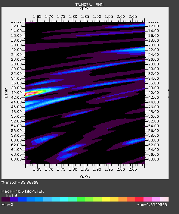
| Estimated Moho Depth: |
40.5 km |
| Estimated Crust Vp/Vs: |
1.60 |
| Assumed Crust Vp: |
6.571 km/s |
| Estimated Crust Vs: |
4.107 km/s |
| Estimated Crust Poisson's Ratio: |
0.18 |
|
| Radial Match: |
83.86868 % |
| Radial Bump: |
400 |
| Transverse Match: |
64.81623 % |
| Transverse Bump: |
400 |
| SOD ConfigId: |
2564 |
| Insert Time: |
2010-03-07 02:44:01.916 +0000 |
| GWidth: |
2.5 |
| Max Bumps: |
400 |
| Tol: |
0.001 |
|
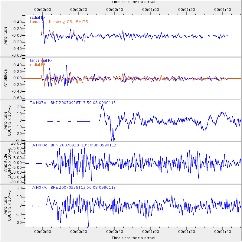
Signal To Noise
| Channel | StoN | STA | LTA |
| TA:H07A: :BHN:20070928T13:50:08.099011Z | 14.401193 | 1.4258524E-6 | 9.900933E-8 |
| TA:H07A: :BHE:20070928T13:50:08.099011Z | 42.88208 | 4.7177123E-6 | 1.1001594E-7 |
| TA:H07A: :BHZ:20070928T13:50:08.099011Z | 90.2219 | 1.18605085E-5 | 1.3145932E-7 |
| Arrivals |
| Ps | 3.8 SECOND |
| PpPs | 16 SECOND |
| PsPs/PpSs | 19 SECOND |


