
Station TA H07A - Lands Inn, Kimberly, OR, USA
Network: TA - USArray Transportable Network (new EarthScope stations)
Nearby stations (2 deg radius)
| Station | Name | (Lat, Lon) | Start / End | Elevation |
| H07A | Lands Inn, Kimberly, OR, USA | (44.59, -119.56) | 2006-08-15 / 2499-01-01 | 1.2 km |
| Crust2 Type: | Q9,orogen/41km no ice, cordilleras, 0.25 km seds. |
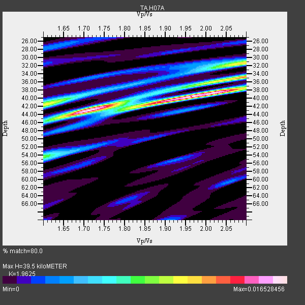
| Thickness Estimate: | 40 km |
| Thickness StdDev: | 2.7 km |
| Vp/Vs Estimate: | 1.96 |
| Vp/Vs StdDev: | 0.15 |
| Vs Estimate: | 3.348 km/s |
| Poisson's Ratio: | 0.32 |
| Peak Value: | 0.02 |
| Assumed Vp: | 6.571 km/s |
| Ps Weight: | 0.33333334 |
| PpPs Weight: | 0.33333334 |
| PsPs Weight: | 0.33333328 |
| Residual Complexity: | 0.694 |
| Nearby stations H: | +- |
| (2.0 deg) Vp/Vs: | +- |
8 with match > 90% ( 17.021276 %) and 36 with match > 80% ( 76.59574 %) out of 47.
Download stack as xyz text file.
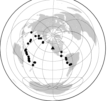
Azimuth Distribution of Events:
Prior Results for this Station
| Study | Thickness | Vp/Vs | Vp | Vs | Poissons Ratio | Extra |
| EARS | 40 km | 1.96 | 6.571 km/s | 3.348 km/s | 0.32 | |
| Crust2.0 | 41 km | 1.76 | 6.571 km/s | 3.735 km/s | 0.26 | Q9,orogen/41km no ice, cordilleras, 0.25 km seds. |
| Global Maxima | 40 km | 1.96 | 6.571 km/s | 3.348 km/s | 0.32 | amp=0.016528456 |
| Local Maxima 1 | 43 km | 1.72 | 6.571 km/s | 3.831 km/s | 0.24 | amp=0.012654325 |
| Local Maxima 2 | 31 km | 2.09 | 6.571 km/s | 3.14 km/s | 0.35 | amp=0.011163333 |
| Local Maxima 3 | 42 km | 1.60 | 6.571 km/s | 4.1 km/s | 0.18 | amp=0.010194827 |
| Local Maxima 4 | 54 km | 1.60 | 6.571 km/s | 4.107 km/s | 0.18 | amp=0.0061922846 |
| Predicted Arrivals for vertical incidence (zero ray parameter) | |
| Ps | 5.79 SECOND |
| PpPs | 17.81 SECOND |
| PsPs/PpSs | 23.60 SECOND |
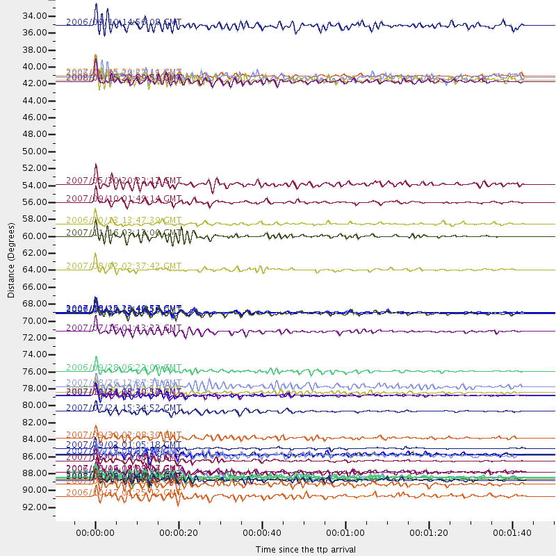
Events Processed for this Station
Download zip of receiver functions as SAC
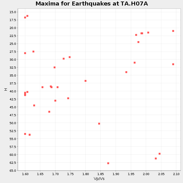
Plot maxima for each earthquake.
Events Used in the Stack
(36 events)| Radial Match | Distance | Baz | FERegion | Time | Lat/Lon | Depth | Magnitude |
| 97.78766 | 87.4 deg | 251.071 deg | Santa Cruz Islands | 2007/09/02 01:05:18 GMT | (-11.6, 165.8) | 35 km | 5.9 MB, 7.3 MS, 7.2 MW, 6.9 ME |
| 93.93325 | 69.6 deg | 134.975 deg | Near Coast Of Peru | 2007/08/15 23:40:57 GMT | (-13.4, -76.6) | 39 km | 6.7 MB, 7.9 MS, 8.0 MW, 7.5 ME |
| 93.57299 | 77.4 deg | 231.196 deg | Samoa Islands Region | 2006/09/28 06:22:09 GMT | (-16.6, -172.0) | 28 km | 6.5 MB, 6.6 MS, 6.9 MW, 6.7 MW |
| 92.95731 | 91.2 deg | 259.39 deg | Solomon Islands | 2007/04/01 20:39:56 GMT | (-8.5, 157.0) | 10 km | 6.8 MB, 7.9 MS, 8.1 MW, 7.7 ME |
| 92.312584 | 55.3 deg | 126.22 deg | Near West Coast Of Colombia | 2007/09/10 01:49:14 GMT | (3.0, -78.0) | 31 km | 6.1 MB, 6.7 MS, 6.8 MW |
| 91.84286 | 90.5 deg | 243.854 deg | Vanuatu Islands | 2006/10/03 18:03:14 GMT | (-18.9, 169.0) | 171 km | 5.9 MB, 6.3 MW, 6.3 MW |
| 91.35781 | 89.0 deg | 246.995 deg | Vanuatu Islands | 2007/08/01 17:08:51 GMT | (-15.6, 167.7) | 120 km | 6.2 MB, 7.2 MW, 7.2 MW |
| 91.25764 | 80.5 deg | 134.265 deg | Northern Chile | 2007/11/14 15:40:50 GMT | (-22.2, -69.9) | 40 km | 6.7 MB, 7.4 MS, 7.7 MW, 7.4 ME |
| 88.0446 | 90.5 deg | 256.736 deg | Solomon Islands | 2007/08/16 08:39:27 GMT | (-9.8, 159.5) | 10 km | 6.1 MB, 6.7 MS, 6.4 MW |
| 88.04205 | 91.5 deg | 243.121 deg | Loyalty Islands | 2008/04/09 12:46:12 GMT | (-20.1, 168.9) | 33 km | 6.3 MB, 7.3 MS, 7.3 MW, 7.3 MW |
| 87.95176 | 38.8 deg | 299.748 deg | Andreanof Islands, Aleutian Is. | 2007/08/15 20:22:11 GMT | (50.3, -177.5) | 9.0 km | 6.3 MB, 6.2 MS, 6.4 MW, 5.9 ML |
| 87.78643 | 72.2 deg | 305.222 deg | Near West Coast Of Honshu, Japan | 2007/07/16 01:13:22 GMT | (37.5, 138.4) | 12 km | 6.5 MB, 6.4 MS, 6.6 MW, 6.5 MW |
| 87.5157 | 88.3 deg | 246.491 deg | Vanuatu Islands | 2007/07/15 09:27:34 GMT | (-15.4, 168.6) | 8.0 km | 6.0 MB, 5.8 MS, 6.1 MW, 6.0 MW |
| 87.27052 | 59.7 deg | 129.611 deg | Peru-Ecuador Border Region | 2007/11/16 03:13:00 GMT | (-2.3, -77.8) | 123 km | 6.3 MB, 6.8 MW, 6.7 MW |
| 86.94938 | 80.5 deg | 287.013 deg | Mariana Islands | 2007/10/31 03:30:17 GMT | (18.9, 145.4) | 223 km | 6.2 MB, 7.2 MW, 7.2 MW |
| 86.74968 | 39.5 deg | 302.549 deg | Andreanof Islands, Aleutian Is. | 2008/04/15 22:59:51 GMT | (51.9, -179.4) | 10 km | 6.1 MB, 6.4 MS, 6.4 MW, 6.4 MW |
| 85.28 | 93.7 deg | 265.439 deg | New Britain Region, P.N.G. | 2006/10/17 01:25:12 GMT | (-5.9, 151.0) | 32 km | 6.4 MB, 6.9 MS, 6.7 MW, 6.6 MW |
| 84.91617 | 92.1 deg | 267.106 deg | New Ireland Region, P.N.G. | 2007/06/18 06:18:48 GMT | (-3.6, 151.0) | 26 km | 5.7 MB, 6.2 MS, 6.3 MW, 6.1 MW |
| 84.76388 | 52.9 deg | 309.872 deg | Kamchatka Peninsula, Russia | 2007/05/30 20:22:12 GMT | (52.1, 157.3) | 116 km | 6.4 MB, 6.4 MW, 6.4 MW |
| 84.71379 | 91.2 deg | 240.774 deg | Southeast Of Loyalty Islands | 2007/07/27 14:46:26 GMT | (-21.5, 170.9) | 10 km | 6.0 MB, 6.0 MS, 6.1 MW, 6.1 MW |
| 84.65988 | 69.7 deg | 135.079 deg | Near Coast Of Peru | 2006/10/20 10:48:56 GMT | (-13.5, -76.7) | 23 km | 5.9 MB, 6.6 MS, 6.7 MW, 6.6 MW |
| 84.63311 | 39.2 deg | 132.3 deg | Near Coast Of Guatemala | 2007/06/08 13:32:00 GMT | (13.8, -90.8) | 48 km | 5.5 MB, 5.4 MS, 5.8 MW, 5.8 MW |
| 83.933426 | 86.1 deg | 280.71 deg | South Of Mariana Islands | 2007/09/30 02:08:30 GMT | (10.5, 145.7) | 14 km | 6.4 MB, 7.1 MS, 6.9 MW, 6.9 MW |
| 83.86868 | 80.2 deg | 291.062 deg | Volcano Islands, Japan Region | 2007/09/28 13:38:59 GMT | (22.0, 142.7) | 276 km | 6.7 MB, 7.4 MW, 7.4 MW |
| 82.7653 | 91.6 deg | 242.431 deg | Vanuatu Islands | 2007/03/25 00:40:01 GMT | (-20.6, 169.4) | 34 km | 6.5 MB, 7.0 MS, 7.1 MW, 7.1 MW |
| 82.47664 | 88.3 deg | 229.736 deg | South Of Fiji Islands | 2007/07/18 00:07:35 GMT | (-26.3, -177.7) | 10 km | 5.8 MB, 5.9 MS, 6.1 MW, 6.0 MW |
| 82.44674 | 38.9 deg | 132.734 deg | Near Coast Of Guatemala | 2006/12/03 20:52:15 GMT | (14.0, -91.2) | 61 km | 5.8 MB, 5.9 MW, 5.9 MW |
| 82.382515 | 88.2 deg | 229.794 deg | South Of Fiji Islands | 2007/07/17 09:39:27 GMT | (-26.2, -177.7) | 10 km | 5.7 MB, 6.0 MS, 6.1 MW, 6.0 MW |
| 82.38231 | 58.1 deg | 305.282 deg | Kuril Islands | 2006/10/13 13:47:39 GMT | (46.3, 153.3) | 8.0 km | 5.5 MB, 5.8 MS, 6.3 MW, 5.8 MW |
| 81.581 | 69.8 deg | 135.092 deg | Near Coast Of Peru | 2007/08/17 13:18:13 GMT | (-13.6, -76.6) | 48 km | 5.6 MB, 5.6 MS, 5.9 MW |
| 81.40735 | 79.4 deg | 232.5 deg | Tonga Islands | 2007/08/26 12:37:31 GMT | (-17.5, -174.3) | 127 km | 5.9 MB, 6.1 MW |
| 81.212364 | 91.1 deg | 261.66 deg | Solomon Islands | 2006/09/01 10:18:51 GMT | (-6.8, 155.5) | 38 km | 6.3 MB, 6.7 MS, 6.8 MW, 6.7 MW |
| 80.91838 | 64.0 deg | 311.322 deg | Sakhalin, Russia | 2007/08/02 02:37:42 GMT | (47.1, 141.8) | 5.0 km | 6.2 MS, 5.3 MB, 6.2 MW, 6.2 MW |
| 80.53266 | 32.2 deg | 113.451 deg | Gulf Of Mexico | 2006/09/10 14:56:08 GMT | (26.3, -86.6) | 14 km | 5.9 MB, 5.5 MS, 5.8 MW, 5.8 MW |
| 80.296135 | 82.6 deg | 131.036 deg | Jujuy Province, Argentina | 2007/07/21 15:34:52 GMT | (-22.2, -65.8) | 290 km | 5.8 MB, 6.4 MW, 6.3 MW |
| 80.25973 | 91.2 deg | 306.492 deg | Taiwan Region | 2007/09/06 17:51:26 GMT | (24.3, 122.2) | 53 km | 6.1 MB, 6.2 MW, 6.1 ME |
Losers
(11 events)| Radial Match | Distance | Baz | FERegion | Time | Lat/Lon | Depth | Magnitude | Reason |
| 78.59967 | 39.4 deg | 302.541 deg | Andreanof Islands, Aleutian Is. | 2008/04/16 05:54:19 GMT | (51.9, -179.2) | 13 km | 6.1 MB, 6.5 MS, 6.6 MW, 6.6 MW | |
| 76.85367 | 91.8 deg | 242.947 deg | Loyalty Islands | 2008/04/11 17:45:05 GMT | (-20.4, 168.8) | 35 km | 5.7 MB, 5.9 MS, 6.0 MW, 6.0 MW | |
| 75.52209 | 58.1 deg | 305.481 deg | Kuril Islands | 2008/03/03 09:31:02 GMT | (46.4, 153.2) | 10 km | 6.2 MB, 6.5 MS, 6.5 MW, 6.5 MW | |
| 75.376564 | 39.6 deg | 132.316 deg | Near Coast Of Guatemala | 2008/04/15 03:03:04 GMT | (13.6, -90.6) | 33 km | 5.6 MB, 5.8 MS, 6.1 MW, 6.1 MW | |
| 75.30011 | 91.6 deg | 243.072 deg | Loyalty Islands | 2008/04/09 11:13:17 GMT | (-20.2, 168.9) | 13 km | 5.6 MB, 6.3 MS, 6.4 MW, 6.3 MW | |
| 71.281265 | 90.5 deg | 227.74 deg | Kermadec Islands, New Zealand | 2008/03/18 08:22:47 GMT | (-29.3, -177.4) | 25 km | 5.8 MB, 6.1 MS, 6.2 MW, 6.2 MW | |
| 70.86298 | 89.9 deg | 246.577 deg | Vanuatu Islands | 2008/03/12 11:23:34 GMT | (-16.6, 167.3) | 13 km | 5.8 MB, 6.4 MS, 6.4 MW, 6.4 MW | |
| 69.49173 | 79.2 deg | 132.293 deg | Chile-Bolivia Border Region | 2008/03/24 20:39:07 GMT | (-20.0, -69.0) | 120 km | 5.7 MB, 6.2 MW, 6.1 MW | |
| 68.47714 | 39.0 deg | 302.899 deg | Andreanof Islands, Aleutian Is. | 2008/03/22 21:24:11 GMT | (52.2, -178.7) | 132 km | 5.8 MB, 6.2 MW, 6.1 MW | |
| 62.372032 | 91.7 deg | 242.912 deg | Loyalty Islands | 2008/04/10 01:10:02 GMT | (-20.3, 168.9) | 35 km | 5.5 MB, 5.5 MS, 5.8 MW | |
| 62.108135 | 91.6 deg | 243.035 deg | Loyalty Islands | 2008/04/09 11:23:40 GMT | (-20.2, 168.9) | 35 km | 5.7 MB, 6.3 MW, 6.3 MW |
