You are here: Home > Network List > TA - USArray Transportable Network (new EarthScope stations) Stations List
> Station H07A Lands Inn, Kimberly, OR, USA > Earthquake Result Viewer
H07A Lands Inn, Kimberly, OR, USA - Earthquake Result Viewer
| Earthquake location: |
Andreanof Islands, Aleutian Is. |
| Earthquake latitude/longitude: |
50.3/-177.5 |
| Earthquake time(UTC): |
2007/08/15 (227) 20:22:11 GMT |
| Earthquake Depth: |
9.0 km |
| Earthquake Magnitude: |
6.3 MB, 6.2 MS, 6.4 MW, 5.9 ML |
| Earthquake Catalog/Contributor: |
WHDF/NEIC |
|
| Network: |
TA USArray Transportable Network (new EarthScope stations) |
| Station: |
H07A Lands Inn, Kimberly, OR, USA |
| Lat/Lon: |
44.59 N/119.56 W |
| Elevation: |
1204 m |
|
| Distance: |
38.8 deg |
| Az: |
75.405 deg |
| Baz: |
299.748 deg |
| Ray Param: |
0.075380534 |
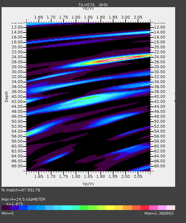
| Estimated Moho Depth: |
24.5 km |
| Estimated Crust Vp/Vs: |
1.98 |
| Assumed Crust Vp: |
6.571 km/s |
| Estimated Crust Vs: |
3.327 km/s |
| Estimated Crust Poisson's Ratio: |
0.33 |
|
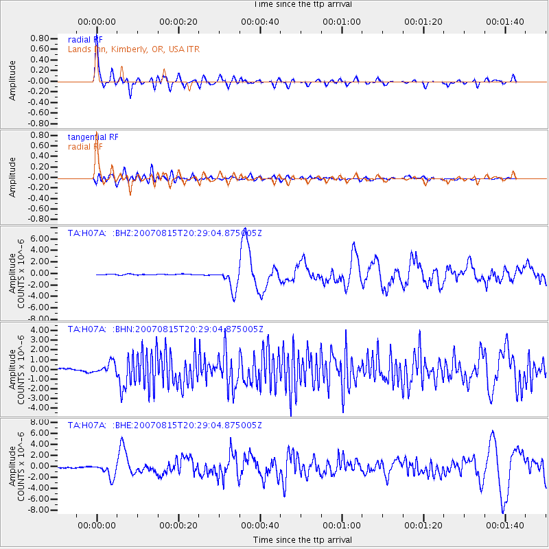
| Radial Match: |
87.95176 % |
| Radial Bump: |
400 |
| Transverse Match: |
54.341698 % |
| Transverse Bump: |
400 |
| SOD ConfigId: |
2564 |
| Insert Time: |
2010-03-07 02:44:13.994 +0000 |
| GWidth: |
2.5 |
| Max Bumps: |
400 |
| Tol: |
0.001 |
|
Signal To Noise
| Channel | StoN | STA | LTA |
| TA:H07A: :BHN:20070815T20:29:04.875005Z | 3.3363624 | 6.1072626E-7 | 1.8305154E-7 |
| TA:H07A: :BHE:20070815T20:29:04.875005Z | 9.767242 | 1.3345698E-6 | 1.3663731E-7 |
| TA:H07A: :BHZ:20070815T20:29:04.875005Z | 27.547039 | 1.9691367E-6 | 7.14827E-8 |
| Arrivals |
| Ps | 3.9 SECOND |
| PpPs | 10 SECOND |
| PsPs/PpSs | 14 SECOND |


