You are here: Home > Network List > TA - USArray Transportable Network (new EarthScope stations) Stations List
> Station H07A Lands Inn, Kimberly, OR, USA > Earthquake Result Viewer
H07A Lands Inn, Kimberly, OR, USA - Earthquake Result Viewer
| Earthquake location: |
Southeast Of Loyalty Islands |
| Earthquake latitude/longitude: |
-21.5/170.9 |
| Earthquake time(UTC): |
2007/07/27 (208) 14:46:26 GMT |
| Earthquake Depth: |
10 km |
| Earthquake Magnitude: |
6.0 MB, 6.0 MS, 6.1 MW, 6.1 MW |
| Earthquake Catalog/Contributor: |
WHDF/NEIC |
|
| Network: |
TA USArray Transportable Network (new EarthScope stations) |
| Station: |
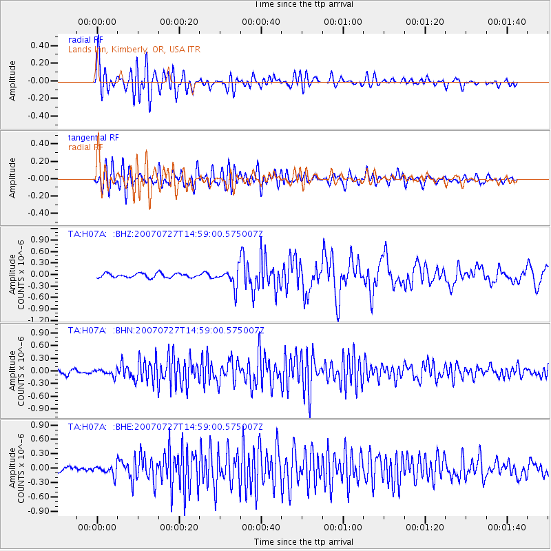
H07A Lands Inn, Kimberly, OR, USA |
| Lat/Lon: |
44.59 N/119.56 W |
| Elevation: |
1204 m |
|
| Distance: |
91.2 deg |
| Az: |
42.019 deg |
| Baz: |
240.774 deg |
| Ray Param: |
0.04161736 |
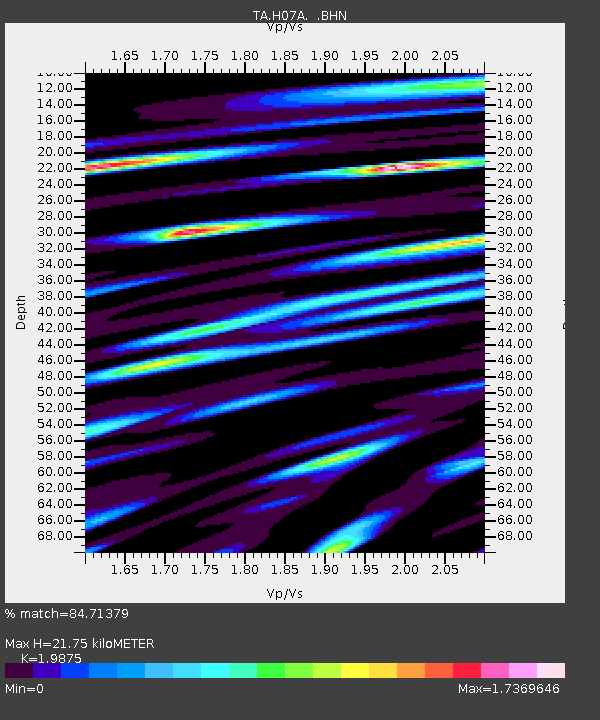
| Estimated Moho Depth: |
21.75 km |
| Estimated Crust Vp/Vs: |
1.99 |
| Assumed Crust Vp: |
6.571 km/s |
| Estimated Crust Vs: |
3.306 km/s |
| Estimated Crust Poisson's Ratio: |
0.33 |
|
| Radial Match: |
84.71379 % |
| Radial Bump: |
400 |
| Transverse Match: |
87.88262 % |
| Transverse Bump: |
400 |
| SOD ConfigId: |
2564 |
| Insert Time: |
2010-03-07 02:44:17.421 +0000 |
| GWidth: |
2.5 |
| Max Bumps: |
400 |
| Tol: |
0.001 |
|
Signal To Noise
| Channel | StoN | STA | LTA |
| TA:H07A: :BHN:20070727T14:59:00.575007Z | 1.214647 | 7.604448E-8 | 6.260624E-8 |
| TA:H07A: :BHE:20070727T14:59:00.575007Z | 1.7650212 | 1.03399636E-7 | 5.8582657E-8 |
| TA:H07A: :BHZ:20070727T14:59:00.575007Z | 4.463486 | 2.4778365E-7 | 5.551348E-8 |
| Arrivals |
| Ps | 3.3 SECOND |
| PpPs | 9.7 SECOND |
| PsPs/PpSs | 13 SECOND |


