You are here: Home > Network List > TA - USArray Transportable Network (new EarthScope stations) Stations List
> Station H07A Lands Inn, Kimberly, OR, USA > Earthquake Result Viewer
H07A Lands Inn, Kimberly, OR, USA - Earthquake Result Viewer
| Earthquake location: |
New Ireland Region, P.N.G. |
| Earthquake latitude/longitude: |
-3.6/151.0 |
| Earthquake time(UTC): |
2007/06/18 (169) 06:18:48 GMT |
| Earthquake Depth: |
26 km |
| Earthquake Magnitude: |
5.7 MB, 6.2 MS, 6.3 MW, 6.1 MW |
| Earthquake Catalog/Contributor: |
WHDF/NEIC |
|
| Network: |
TA USArray Transportable Network (new EarthScope stations) |
| Station: |
H07A Lands Inn, Kimberly, OR, USA |
| Lat/Lon: |
44.59 N/119.56 W |
| Elevation: |
1204 m |
|
| Distance: |
92.1 deg |
| Az: |
45.638 deg |
| Baz: |
267.106 deg |
| Ray Param: |
0.041502587 |
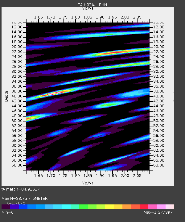
| Estimated Moho Depth: |
38.75 km |
| Estimated Crust Vp/Vs: |
1.71 |
| Assumed Crust Vp: |
6.571 km/s |
| Estimated Crust Vs: |
3.848 km/s |
| Estimated Crust Poisson's Ratio: |
0.24 |
|
| Radial Match: |
84.91617 % |
| Radial Bump: |
400 |
| Transverse Match: |
73.719124 % |
| Transverse Bump: |
400 |
| SOD ConfigId: |
2564 |
| Insert Time: |
2010-03-07 02:44:30.051 +0000 |
| GWidth: |
2.5 |
| Max Bumps: |
400 |
| Tol: |
0.001 |
|
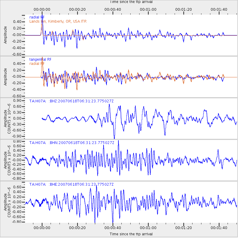
Signal To Noise
| Channel | StoN | STA | LTA |
| TA:H07A: :BHN:20070618T06:31:23.775027Z | 1.1871458 | 9.6167874E-8 | 8.1007634E-8 |
| TA:H07A: :BHE:20070618T06:31:23.775027Z | 2.2312734 | 1.3037895E-7 | 5.8432533E-8 |
| TA:H07A: :BHZ:20070618T06:31:23.775027Z | 2.1276286 | 1.633135E-7 | 7.675847E-8 |
| Arrivals |
| Ps | 4.3 SECOND |
| PpPs | 16 SECOND |
| PsPs/PpSs | 20 SECOND |


