You are here: Home > Network List > TA - USArray Transportable Network (new EarthScope stations) Stations List
> Station H07A Lands Inn, Kimberly, OR, USA > Earthquake Result Viewer
H07A Lands Inn, Kimberly, OR, USA - Earthquake Result Viewer
| Earthquake location: |
Near Coast Of Peru |
| Earthquake latitude/longitude: |
-13.5/-76.7 |
| Earthquake time(UTC): |
2006/10/20 (293) 10:48:56 GMT |
| Earthquake Depth: |
23 km |
| Earthquake Magnitude: |
5.9 MB, 6.6 MS, 6.7 MW, 6.6 MW |
| Earthquake Catalog/Contributor: |
WHDF/NEIC |
|
| Network: |
TA USArray Transportable Network (new EarthScope stations) |
| Station: |
H07A Lands Inn, Kimberly, OR, USA |
| Lat/Lon: |
44.59 N/119.56 W |
| Elevation: |
1204 m |
|
| Distance: |
69.7 deg |
| Az: |
328.763 deg |
| Baz: |
135.079 deg |
| Ray Param: |
0.055469442 |
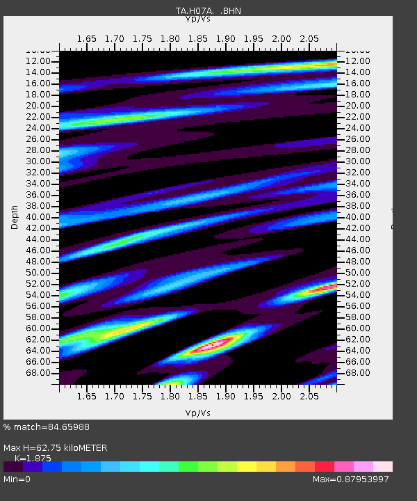
| Estimated Moho Depth: |
62.75 km |
| Estimated Crust Vp/Vs: |
1.88 |
| Assumed Crust Vp: |
6.571 km/s |
| Estimated Crust Vs: |
3.504 km/s |
| Estimated Crust Poisson's Ratio: |
0.30 |
|
| Radial Match: |
84.65988 % |
| Radial Bump: |
400 |
| Transverse Match: |
71.559425 % |
| Transverse Bump: |
400 |
| SOD ConfigId: |
2564 |
| Insert Time: |
2010-03-07 02:44:39.996 +0000 |
| GWidth: |
2.5 |
| Max Bumps: |
400 |
| Tol: |
0.001 |
|

Signal To Noise
| Channel | StoN | STA | LTA |
| TA:H07A: :BHN:20061020T10:59:32.475027Z | 1.9213138 | 3.3836008E-7 | 1.761087E-7 |
| TA:H07A: :BHE:20061020T10:59:32.475027Z | 1.3586806 | 3.2406393E-7 | 2.385137E-7 |
| TA:H07A: :BHZ:20061020T10:59:32.475027Z | 6.76443 | 1.0094075E-6 | 1.4922284E-7 |
| Arrivals |
| Ps | 8.7 SECOND |
| PpPs | 26 SECOND |
| PsPs/PpSs | 35 SECOND |


