You are here: Home > Network List > TA - USArray Transportable Network (new EarthScope stations) Stations List
> Station H07A Lands Inn, Kimberly, OR, USA > Earthquake Result Viewer
H07A Lands Inn, Kimberly, OR, USA - Earthquake Result Viewer
| Earthquake location: |
Vanuatu Islands |
| Earthquake latitude/longitude: |
-18.9/169.0 |
| Earthquake time(UTC): |
2006/10/03 (276) 18:03:14 GMT |
| Earthquake Depth: |
171 km |
| Earthquake Magnitude: |
5.9 MB, 6.3 MW, 6.3 MW |
| Earthquake Catalog/Contributor: |
WHDF/NEIC |
|
| Network: |
TA USArray Transportable Network (new EarthScope stations) |
| Station: |
H07A Lands Inn, Kimberly, OR, USA |
| Lat/Lon: |
44.59 N/119.56 W |
| Elevation: |
1204 m |
|
| Distance: |
90.5 deg |
| Az: |
42.635 deg |
| Baz: |
243.854 deg |
| Ray Param: |
0.041629206 |
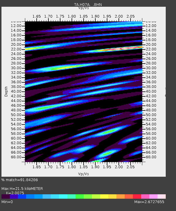
| Estimated Moho Depth: |
21.5 km |
| Estimated Crust Vp/Vs: |
2.01 |
| Assumed Crust Vp: |
6.571 km/s |
| Estimated Crust Vs: |
3.273 km/s |
| Estimated Crust Poisson's Ratio: |
0.33 |
|
| Radial Match: |
91.84286 % |
| Radial Bump: |
400 |
| Transverse Match: |
88.59132 % |
| Transverse Bump: |
400 |
| SOD ConfigId: |
2665 |
| Insert Time: |
2010-03-07 02:44:47.501 +0000 |
| GWidth: |
2.5 |
| Max Bumps: |
400 |
| Tol: |
0.001 |
|

Signal To Noise
| Channel | StoN | STA | LTA |
| TA:H07A: :BHN:20061003T18:15:25.824019Z | 8.351668 | 5.9750556E-7 | 7.1543255E-8 |
| TA:H07A: :BHE:20061003T18:15:25.824019Z | 5.15914 | 6.43776E-7 | 1.2478358E-7 |
| TA:H07A: :BHZ:20061003T18:15:25.824019Z | 23.277681 | 1.5507419E-6 | 6.661926E-8 |
| Arrivals |
| Ps | 3.4 SECOND |
| PpPs | 9.7 SECOND |
| PsPs/PpSs | 13 SECOND |


