You are here: Home > Network List > TA - USArray Transportable Network (new EarthScope stations) Stations List
> Station H07A Lands Inn, Kimberly, OR, USA > Earthquake Result Viewer
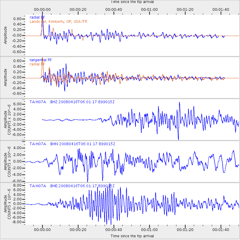
H07A Lands Inn, Kimberly, OR, USA - Earthquake Result Viewer
*The percent match for this event was below the threshold and hence no stack was calculated.
| Earthquake location: |
Andreanof Islands, Aleutian Is. |
| Earthquake latitude/longitude: |
51.9/-179.2 |
| Earthquake time(UTC): |
2008/04/16 (107) 05:54:19 GMT |
| Earthquake Depth: |
13 km |
| Earthquake Magnitude: |
6.1 MB, 6.5 MS, 6.6 MW, 6.6 MW |
| Earthquake Catalog/Contributor: |
WHDF/NEIC |
|
| Network: |
TA USArray Transportable Network (new EarthScope stations) |
| Station: |
H07A Lands Inn, Kimberly, OR, USA |
| Lat/Lon: |
44.59 N/119.56 W |
| Elevation: |
1204 m |
|
| Distance: |
39.4 deg |
| Az: |
76.319 deg |
| Baz: |
302.541 deg |
| Ray Param: |
$rayparam |
*The percent match for this event was below the threshold and hence was not used in the summary stack. |
|
| Radial Match: |
78.59967 % |
| Radial Bump: |
400 |
| Transverse Match: |
66.18411 % |
| Transverse Bump: |
400 |
| SOD ConfigId: |
2504 |
| Insert Time: |
2010-03-07 02:45:08.396 +0000 |
| GWidth: |
2.5 |
| Max Bumps: |
400 |
| Tol: |
0.001 |
|
Signal To Noise
| Channel | StoN | STA | LTA |
| TA:H07A: :BHN:20080416T06:01:17.899015Z | 4.3094344 | 6.314014E-7 | 1.4651607E-7 |
| TA:H07A: :BHE:20080416T06:01:17.899015Z | 2.830085 | 3.256241E-7 | 1.15058064E-7 |
| TA:H07A: :BHZ:20080416T06:01:17.899015Z | 2.6803546 | 4.0112397E-7 | 1.4965332E-7 |
| Arrivals |
| Ps | |
| PpPs | |
| PsPs/PpSs | |


