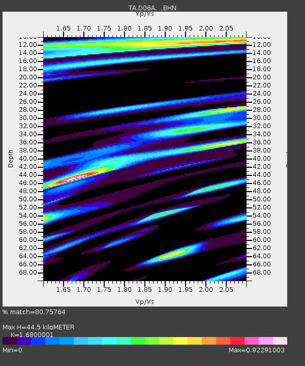
D06A Cle Elum, WA, USA - Earthquake Result Viewer
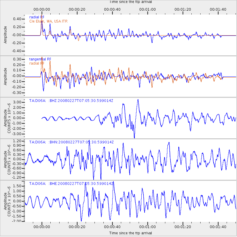
Earthquake location: Bonin Islands, Japan Region
Earthquake latitude/longitude: 26.8/142.4
Earthquake time(UTC): 2008/02/27 (058) 06:54:20 GMT
Earthquake Depth: 15 km
Earthquake Magnitude: 5.8 MB, 6.1 MS, 6.2 MW, 6.2 MW
Earthquake Catalog/Contributor: WHDF/NEIC
Network: TA USArray Transportable Network (new EarthScope stations)
Station: D06A Cle Elum, WA, USA
Lat/Lon: 47.19 N/120.84 W
Elevation: 575 m
Distance: 75.1 deg
Az: 44.492 deg
Baz: 293.313 deg
Ray Param: 0.05187364
Estimated Moho Depth: 44.5 km
Estimated Crust Vp/Vs: 1.68
Assumed Crust Vp: 6.597 km/s
Estimated Crust Vs: 3.927 km/s
Estimated Crust Poisson's Ratio: 0.23
Radial Match: 80.75764 %
Radial Bump: 400
Transverse Match: 66.34775 %
Transverse Bump: 400
SOD ConfigId: 2564
Insert Time: 2010-03-07 02:52:45.204 +0000
GWidth: 2.5
Max Bumps: 400
Tol: 0.001

Signal To Noise

ChannelStoNSTALTA
TA:D06A: :BHN:20080227T07:05:30.599014Z0.730176271.6586645E-72.2715945E-7
TA:D06A: :BHE:20080227T07:05:30.599014Z1.32665543.6273443E-72.7342023E-7
TA:D06A: :BHZ:20080227T07:05:30.599014Z2.6871455.7932334E-72.1559065E-7
Arrivals
Ps4.8 SECOND
PpPs17 SECOND
PsPs/PpSs22 SECOND